

Medium Range Air Quality Outlook
Mid-Atlantic Region
Issued: Monday, May 21, 2018
Valid: May 22-26 (Tuesday-Saturday)
![]()

Summary
The medium range period begins quietly with unsettled conditions on Tuesday, a cold frontal passage on Wednesday, and then generally clean post-frontal conditions on Thursday, for only a Slight chance of an ozone exceedance. Friday and Saturday are the days of interest for the medium range period, with a Marginal risk of an ozone exceedance, mainly focused in the NMA. During this time, the Mid-Atlantic will be sandwiched between three major weather features: the Bermuda High to the east, a tropical disturbance in the Gulf of Mexico/Gulf Coast, and a shortwave moving into the Great Lakes/southern ON. The forecast questions for the end of the period center on how dry and sunny it will remain across the region, especially on Saturday. Friday will be the drier of the two days, with widespread Moderate ozone expected across the NMA and CMA. On Saturday, clouds and precipitation across the SMA and CMA will shift attention to the northern branch of the I-95 Corridor, which will remain sunny with temperatures in the mid-80s °F.
NWP Model Discussion
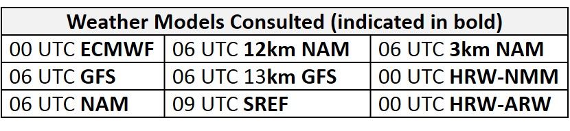
There is general agreement between the weather models with synoptic scale features until around 06Z Wednesday, where the GFS and ECMWF diverge regarding a possible tropical disturbance in the Gulf of Mexico. The medium range period begins on Tuesday with a persistent synoptic pattern over North America. A combination of a strong upper level long wave trough over the Canadian Maritimes, and an upper level cut-off low over the Great Basin, will promote upper level ridging over the Great Plaines on Tuesday. At the same time, a weak shortwave trough, under the influence of the strong upper level longwave trough, will move across the Great Lakes region and into the NMA by 00Z Tuesday. This wave will promote weak troughing over the NMA, and pull a weak cold front through the northern half of the region Tuesday night into Wednesday morning. The NMA will remain on the periphery of the Canadian Maritime longwave trough through Wednesday, as upper level ridging continues to build over the Upper Midwest/Great Lakes region. This setup will allow the western extent of the Bermuda High to slowly build westward, weakly influencing parts of the SMA by Wednesday morning. Most of the Mid-Atlantic will be under the influence of high pressure by Thursday morning as the Midwestern mid-level ridge axis gradually moves eastward. This mid and upper level ridging will continue to build eastward into Friday, moving over the Great Lakes and NMA. On Thursday, shortwave energy will ride along the upper level ridge axis over the Rockies and into the southern Canadian Prairies, reaching southern MB/northern ND by 12Z Friday. This shortwave trough will develop a low pressure system over the northern Great Lakes/southwestern ON by 00Z Saturday that steadily moves east/southeast on Saturday. Coming back to the tropical disturbance, both the GFS and ECMWF have some sort of tropical system located over western Cuba by 00Z Wednesday. The two models diverge with the strength and track of this disturbance as the GFS slowly moves a weaker disturbance northeastward, along the eastern coast of Florida, whereas the ECMWF brings a more organized system through the Gulf and into Louisiana by the end of the medium range period.
The Dailies
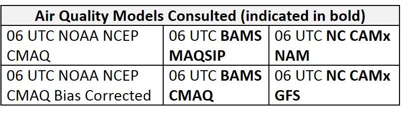
Day 1 (Tuesday): Tuesday will be unsettled across much of the NMA and CMA as the weak upper level shortwave sweeps across the eastern Great Lakes and into the NMA by 00Z Wednesday. The convection-allowing models show two main areas of precipitation affecting the region tomorrow. The first is an MCS-like system moving through PA overnight and into the morning, reaching across most of the northern part of the state by 12Z. A secondary round of convection will develop in the afternoon ahead of an approaching frontal boundary. In the CMA, the convection-allowing models suggest that a moist, southwest flow and stronger diurnal heating will destabilize the environment ahead of the cold front, promoting the development of scattered convection across WV and VA between 21Z Tuesday and 03Z Wednesday. The frontal boundary itself is expected to push just to the southeast of I-90 by 00Z Wednesday. Unsettled conditions across the NMA and CMA will result in a Slight risk of an exceedance across the forecast region. Despite less cloud cover and the lack of precipitation across the southern extent of the region, the chance of an exceedance in the SMA will also be Slight. This will be due to weak influence of the western edge of the Bermuda high promoting southeasterly onshore flow aloft. This is evident in the air quality models as the NC models and the BAMS CMAQ keep widespread Good range ozone across the entire Mid-Atlantic. The BAMS MAQSIP seems to keep some higher ozone values across the NMA, but this could be because the model is not picking up on possible convection across the region.
Day 2 (Wednesday): The approaching cold front from Tuesday will push across the northern half of the Mid-Atlantic on Wednesday, pushing as far south as central NC by 00Z Thursday. This will usher in a noticeably drier air mass across much of the region on Wednesday. A more stable air mass behind the front will also promote gradually clearing skies throughout the day across the NMA and CMA. The slow moving frontal boundary in the SMA will trigger cloudy skies and scattered showers ahead of the boundary. Showers will taper off from west to east of the front slowly moves eastward throughout the day. The air quality models bring some scattered Moderate range ozone across the CMA, possibly in response to increased sunshine during the daytime. The NC models, both the GFS and NAM versions are in agreement with Moderate ozone developing across the CMA. The BAMS models are a little less aggressive keeping the patch of Moderate ozone over eastern WV. Despite the uptick in ozone shown in the air quality models, a fresh air mass in the NMA and CMA as well as unsettled conditions in the SMA will keep a Slight risk of an exceedance on Wednesday.
Day 3 (Thursday): The influence of upper and mid-level ridging will become more evident on Thursday as flow aloft shifts westerly later in the day for the NMA and CMA. Mostly sunny skies appear likely across the Mid-Atlantic and will combine with a less humid air mass to promote above average temperatures. Light surface winds, plenty of strong late May sun, and above average temperatures should be conductive for ozone formation. The eastern half of the region will experience strong northwesterly flow aloft, however, with ample vertical mixing of what should be a relatively clean air mass. This should keep any rising ozone in check along the I-95 Corridor. Western portions of the region, such as the metro PIT area, will feel the influence of the eastward-migrating mid/upper level ridge sooner, and therefore will likely expect ozone to reach into the Moderate range on Thursday. The NC-GFS and BAMS models develop more widespread Moderate ozone across the CMA and western NMA, mainly south of I-76, possibly due to the influence of northerly flow pushing pollutant southward. The NAM versions of the NC model are an outlier and keep most of the Mid-Atlantic under Good ozone. The increasing influence of high pressure will allow ozone concentrations to increase across the Mid-Atlantic, but the risk of an exceedance on Thursday will remain Slight.
Day 4-5 (Friday-Saturday): Friday and Saturday are the days of interest for the medium range period. The Mid-Atlantic will be sandwiched between three major weather features: the Bermuda High to the east, a tropical disturbance in the Gulf of Mexico/Gulf Coast, and a shortwave moving into the Great Lakes/southern ON. The forecast questions for the end of the period center on how dry and sunny it will remain across the region, especially on Saturday. Friday will be the sunnier of the two days, as the axis of high pressure moves overhead. At this time, Friday looks to be another day of mostly sunny skies with slightly above average temperatures across the region. Daytime heating will give the chance for a few isolated thunderstorms in the afternoon hours but they do not appear to be widespread at this time. Continued influence of high pressure can be seen in the air quality models as NC-GFS versions develop some scattered low USG across PA and along the eastern coast of the NMA. This seems very overdone, but suggests a trend toward rising ozone regionally. The BAMS models are much less aggressive in magnitude as they keep widespread low-to-mid Moderate ozone across much of the Mid-Atlantic. Risk of an exceedance on Friday will rise to Marginal.
The tropical disturbance will begin to impact the SMA on Saturday. Widespread unsettled conditions appear likely across the SMA and CMA, however the timing and strength are uncertain at this time. This uncertainty appears to stem from how the GFS and ECMWF handle the track of the tropical disturbance. The GFS favors a more eastward track, bringing the disturbance along the eastern coast of Florida, allowing the weak upper level longwave trough to broaden over the Southeast. The ECMWF on the other hand, brings the disturbance through the Gulf of Mexico, deepening the longwave trough further to the west. The ECMWF solution is currently favored by the WPC and appears to be slightly drier for the SMA than the GFS solution. For now, the risk of an exceedance on Saturday will remain Marginal, primarily for the northern portion of the I-95 Corridor, which appears to remain clear with temperatures in the mid-80s °F.
-Enlow/Huff