Medium Range Air Quality Outlook
Mid-Atlantic Region
Issued: Thursday, May 31, 2018
Valid: June 1-5 (Friday-Tuesday)
![]()

Summary
With the lone exception of a Marginal risk on Friday, June will have a much calmer start than May in the Mid-Atlantic with a Slight risk of an ozone exceedance Saturday through Tuesday. Locally heavy precipitation and thunderstorms will impact most of the Mid-Atlantic on Friday but the eastward push of afternoon thunderstorms is still in question. The GFS and NAM suite of models continue to have completely different solutions; the GFS (and deterministic ECMWF) bring widespread showers and thunderstorms to the I-95 Corridor by the late afternoon. In contrast, the NAM suite of models develop more scattered convection further west and keep the majority of precipitation west of I-95 through 00Z Saturday. Even if showers and thunderstorms do not reach the I-95 Corridor in time to fully suppress ozone formation, the air mass currently in place seems clean enough to limit excessive formation. Out of an abundance of caution, and since we have low confidence in the eastward extent of thunderstorms on Friday, the risk of an ozone exceedance is set at Marginal, with a focus on the I-95 Corridor from Baltimore to north/central NJ. On Saturday, a wave of low pressure and advancing cold front will promote unsettled conditions across most of the region. Widespread cloud cover and scattered precipitation will limit ozone formation. Sunday will be showery, noticeably cooler, and less humid. There is some uncertainty pertaining to the evolution of a strong upper level trough that will develop over the northeastern US beginning on Monday. There is, however, strong confidence that conditions will remain unfavorable for ozone formation. The northerly flow associated a passing low pressure system will pull a much cooler air mass into the NMA and CMA on Monday, eventually filtering into the SMA on Tuesday. Unseasonably cool conditions and the possibility for scattered precipitation will keep the risk of an ozone exceedance Slight on Monday and Tuesday.
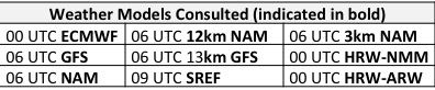
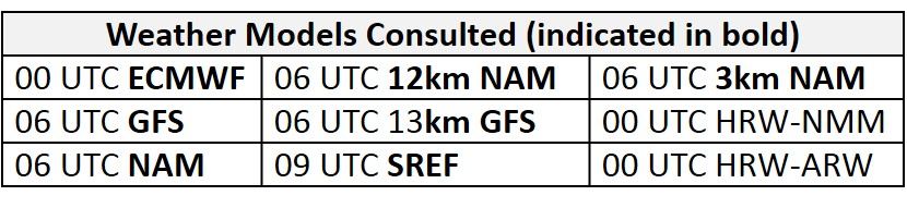
NWP Model Discussion
There is a general agreement between the weather models in regards to two merging longwave troughs that dominate the upper level pattern through the weekend. Subsequently, the GFS and ECMWF quickly diverge regarding the details of a strong upper level trough that will extend southward over the Mid-Atlantic beginning on Monday and continuing through the end of the medium range period. At 12Z Friday, a relatively weak longwave trough will be positively tilted and centered over the Great Lakes/Midwest before moving over the Mid-Atlantic by 12Z Saturday. As this occurs, a ridge building over the interior Plains on Friday will amplify over the Upper Midwest/Great Lakes region by 12Z Saturday as it is pinched by a second longwave trough approaching from the northwest. This stronger secondary longwave trough, centered over the upper Great Plains and southern Canadian Prairies, will continue to progress southeastward, eventually pinching off the base of the ridge as this trough moves over the Great Lakes around 12Z Sunday. The weaker trough over the Mid-Atlantic will break off from the northern stream, potentially closing off over the CMA by 12Z Sunday. By 12Z Monday, the GFS and ECMWF diverge with the progression of these two upper level features. Both models carve out a strong longwave trough over the northeastern US, but the EC has a single closed low, centered over southern ON/QC on Monday and then dropping into NY on Tuesday. In contrast, the GFS keeps the two features separate, with a southern closed low over the Mid-Atlantic on Monday, moving offshore Tuesday, and a second strong shortwave further north over ON. The GFS solution is wetter on Monday and drier on Tuesday, while the EC solution is the reverse. The ECMWF solution seems to be favored by the WPC forecast at this time. Regardless of how the eastern upper level trough evolves on Monday and Tuesday, the synoptic pattern will promote clean air quality.
The Dailies
Day 1 (Friday): Friday remains the lone day of interest in the medium range period as ozone favorable conditions seem possible along the northern stretch of the I-95 Corridor. A few lingering showers will promote mostly cloudy skies in the morning hours before giving way to some breaks in clouds in the afternoon. A very moist air mass with above average temperatures and periods of sunshine in the afternoon hours will be favorable for widespread thunderstorms, with locally heavy precipitation, across most of the Mid-Atlantic. The eastward extent of thunderstorms is still the primary forecast question as there remains a big difference in the solutions between the higher resolution models. The 13-km GFS has the most widespread showers and thunderstorms on Friday with precipitation across the NMA and parts of the CMA throughout the day, including as early as 18-21Z. The NAM based models (3km-NAM and 12km-NAM) as well as the HRW-ARW and HRW-NMM develop more scattered convection further west and keeps the majority of precipitation west of I-95 through 00Z Saturday. These divergent solutions between the GFS and NAM-suite of models have been consistent for the past several days. WPC is leaning toward the wetter GFS (and EC) solutions, but we have low confidence in the timing of thunderstorms on Friday.
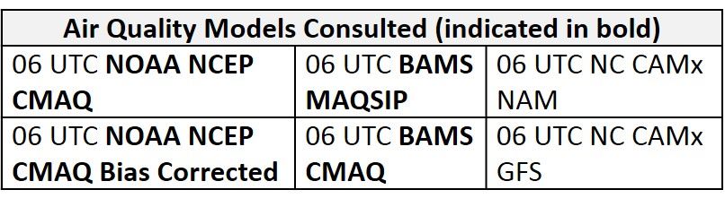
The possible lack of precipitation in conjunction with above average temperatures, light/calm surface winds, and southwesterly flow aloft will be favorable for ozone formation in locations near and along I-95 in the NMA. The air quality models are responding to widespread precipitation and cloud cover over the majority of the Mid-Atlantic, with mostly Good ozone. The BAMS and NOAA models highlight the lack of precipitation and periods of sunshine in the eastern NMA, as they develop Moderate ozone along the I-95 Corridor; the BAMS-MAQSIP is most aggressive, with pockets of upper Moderate to USG ozone. This seems overdone, considering the presumably clean air mass in place, based on consecutive days of onshore flow (and current PM2.5 observations this morning). The very hot NC model didn’t run this morning. Due to the seemingly clean characteristics of the current air mass, we expect that ozone will rise into the Moderate range but most likely will reach the mid-Moderate range at most. Out of an abundance of caution, and since we have low confidence in the eastward extent of thunderstorms on Friday, the risk of an ozone exceedance is set at Marginal, with a focus on the I-95 Corridor from Baltimore to north/central NJ.
Day 2 (Saturday): A wave of low pressure in the CMA will promote unsettled conditions for most of the Mid-Atlantic on Saturday. An associated cold front pushing southward through the NMA and CMA will promote mostly cloudy skies throughout the day. In addition, a much cooler and less humid air mass will begin to filter in behind the front. In the SMA, periods of sunshine and southwesterly flow aloft will allow temperatures to reach above average values. Scattered showers seem likely across most of the region in the afternoon and evening hours. The BAMS air quality models are responding as expected as widespread Good ozone covers the NMA. In the CMA and SMA, both the BAMS MAQSIP and CMAQ develop some upper Good/low Moderate ozone possibly in response to southwesterly flow aloft and the slowly approaching cold front from the north. This seems to be slightly overdone as breezy surface winds, cloud cover and scattered precipitation should be sufficient to limit ozone formation, resulting in a Slight risk of an ozone exceedance.
Day 3 (Sunday): Despite uncertainty in the upper levels, confidence is strong that Sunday will not be favorable for excessive ozone formation. Saturday’s cold front will slowly push southward through the SMA by 12Z Sunday, promoting mostly cloudy skies throughout the day. The arrival of an upper level longwave trough will result in unsettled conditions for most of the NMA and CMA throughout the day but a few locations in the eastern half of the region may experience some periods of sunshine in the late afternoon. Cooler air will continue to filter southward into the region, with below average temperatures reaching as far south as the VA/NC border. Once again the air quality models develop widespread Good ozone across the region in response to cooler conditions and a shift to northerly flow aloft. Near or slightly above average temperatures in the SMA are possibly responsible for some scattered low Moderate in NC but northerly flow and cloud cover will limit any ozone formation. The risk of an ozone exceedance will remain Slight.
Day 4-5 (Monday-Tuesday): Growing uncertainty in the pattern on Monday results in two different outcomes between the ECMWF and GFS for the Mid-Atlantic region. Despite low confidence in the specifics of the forecast, conditions will not be favorable for ozone formation. Relatively strong north/northeasterly flow at mid-levels will promote cold air advection on Monday, resulting in below average temperatures for most of the Mid-Atlantic through Tuesday. Unseasonably cool conditions and the possibility for scattered precipitation will keep the risk of an ozone exceedance Slight on Monday and Tuesday.
-Enlow/Huff