Medium Range Air Quality Outlook
Mid-Atlantic Region
Issued: Friday, June 15, 2018
Valid: June 16-20 (Saturday-Wednesday)
![]()

Summary
A persistent upper/mid-level ridge will result in a string of three days (Sunday-Tuesday) with a High risk of an ozone exceedance. A climatologically favorable pattern for ozone formation will be in place by late Saturday, allowing air quality across the Mid-Atlantic to deteriorate. The arrival of a mid-level ridge over the region and surface high pressure in the NMA will promote mostly sunny skies across the region on Saturday. Weak surface winds across the region, periods of sunshine and near average temperatures will be favorable for ozone formation but will have to overcome ample vertical mixing and increasing afternoon cloud cover. Sunday and Monday present a classic high ozone weather pattern and the risk of an exceedance is High both days. A back door front approaches from the north on Tuesday but the latest model forecasts suggest, with the possible exception of the NMA, it will arrive too late in the day to prevent strong ozone build up. This poor air quality episode is expected to end on Wednesday as the front stalls and brings significant cloud cover to the region.
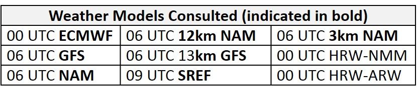
NWP Model Discussion

The weather models continue to be in strong agreement with the synoptic pattern throughout the medium range period. By 12Z Saturday, a longwave trough centered off the Atlantic coast will be departing to the east, allowing an upper/mid-level ridge to move over the eastern US. As the ridge moves eastward, a few shortwave perturbations will propagate across the Great Lakes region and possibly across the NMA. By 12Z Sunday, the ridge will encompass the entire eastern CONUS at upper and mid-levels and will remain centered over the Southeast US until late in the medium range period. Shortwaves moving along the US/Canadian border will reinvigorate a broad longwave trough over eastern Canada that will slowly dampen the ridge beginning around 12Z Monday. At mid-levels, an elongated trough, oriented west to east along the US/Canadian border, will slowly push southward, depressing the ridge and advancing towards the NMA on Tuesday. The southward push of a cold front associated with this trough will be the primary source of uncertainty throughout the medium range period. Although earlier forecasts had this boundary reaching the NMA on Tuesday, the current models have this delayed until 12Z Wednesday.
The Dailies
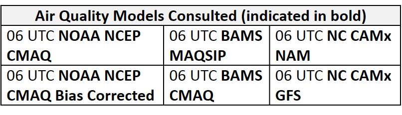
Day 1 (Saturday): Saturday will kick off a string of days with an elevated risk for an ozone exceedance. The arrival of the mid-level ridge over the region and surface high pressure in the NMA will promote mostly sunny skies across the region in the morning hours. The weather models hint at shortwave perturbations passing over the NMA/CMA throughout the day, providing the opportunity for increasing cloud cover and possibly precipitation. The GFS and ECMWF keep precipitation out of the NMA but convection-allowing models suggest that a complex of thunderstorms could push southward into PA sometime in the afternoon hours. Despite the uncertainty with precipitation, conditions across most of the region will be favorable for ozone formation. Across the NMA, northerly back trajectories and lingering cooler air aloft will limit temperatures to near average values. In the SMA, mostly sunny skies and weak southerly/southeasterly flow will result in near average temperatures. The air quality models predict Moderate range ozone over the region. The BAMS models have similar solutions of widespread Moderate ozone with the highest ozone concentrations in the upper Moderate range along the I-95 Corridor, western PA, and west-central NC. The NC models are the most aggressive, with widespread upper Moderate ozone across much of the region and USG ozone developing along the western half of the Mid-Atlantic. The NOAA ozone model is also jumping on board with elevated ozone as it develops pockets of Moderate ozone around PIT, DC, RIC, and large regions of WV. The risk of an ozone exceedance will remain Appreciable with a focus on western PA and locations in the SMA.
Day 2 (Sunday): Conditions on Sunday will be favorable for ozone formation across much of the Mid-Atlantic, warranting a High risk for an ozone exceedance. The forecast placement of the mid-level ridge and surface high pressure in the SMA is climatologically favorable for an ozone exceedance. Increasing atmospheric moisture will combine with above average temperatures resulting in oppressive conditions across a large portion of the Mid-Atlantic. Continued influence from high pressure centered in the SMA will result in calm surface winds with upper level back trajectories shifting westerly in the NMA and CMA. The SMA will have weak onshore transport. The air quality models are responding with a considerable amount of upper Moderate/USG ozone across the NMA and CMA. The BAMS CMAQ and NC models are developing widespread USG ozone along the I-95 Corridor from DC to TTN, locations along and west of the Chesapeake Bay, and in western PA stretching southwest along the Ohio River. The BAMS MAQSIP also highlight elevated ozone concentrations but keep most of the listed locations in the upper Moderate range. Although the areas highlighted in the air quality models will likely experience the highest ozone concentration, the High ozone exceedance risk is not limited to these locations. In addition to the air quality model solutions, a plume of smoke from wildfires across the western US can be seen currently over the central Great Plains and lower Mississippi River Valley. Given the shift to westerly transport of pollutants across the NMA and CMA, this area of smoke will be important to watch today and tomorrow to better gauge its possible impacts on the western half of the Mid-Atlantic on Sunday and into early next week.
Day 3 (Monday): High risk for an ozone exceedance will continue on Monday as oppressive heat and humidity persist. Continued warm air advection and mostly sunny skies will allow temperatures across the region to reach well into the 90s F. The air quality models respond to temperatures well above average and westerly flow across the region with widespread USG conditions. The BAMS models focus USG and High ozone along the eastern NMA and CMA, where westerly surface winds and the development of a lee trough/ sea/bay breezy front could enhance ozone concentrations. The NC-GFS2 and GFS3 develop widespread USG ozone across the entire Mid-Atlantic region with High ozone along the I-95 Corridor in the GFS3. Given these conditions, the risk of an ozone exceedance will remain High for the entire Mid-Atlantic.
Day 4-5 (Tuesday-Wednesday): The risk of an ozone exceedance will remain High for a third consecutive day, Tuesday. The heat wave will continue across the CMA and SMA as high pressure remains over the Southeast US. Mostly sunny skies, westerly transport aloft and weak surface winds will promote ozone formation. The forecast is much more complicated in the NMA as a weak back door cold front will approach the region in the early morning hours and slowly crawl southward throughout the day. The southward push of the front and extent of associated cloud cover and precipitation will be the main forecast question on Tuesday. The models have been trending towards a weaker, slower front that will not push far into the NMA by 12Z Tuesday. Mostly sunny skies in the morning hours will most likely give way to mostly cloudy skies by the late afternoon. Although surface winds are forecast to be breezy and westerly, periods of sunshine during peak heating hours, westerly transport of pollutants, carryover of ozone and its precursors from Monday will promote ozone formation and accumulation on Tuesday. Unsettled conditions will bring relief to the NMA and CMA on Wednesday as the weak cold front nudges into the CMA. Mostly cloudy skies, scattered precipitation and a shift to northerly transport will diminish the risk of an ozone exceedance in the NMA and most of the CMA. In the SMA and the southern CMA, temperatures could remain well above average under continued westerly flow and mostly sunny skies.
-Enlow/Ryan