

Medium Range Air Quality Outlook
Mid-Atlantic Region
Issued: Wednesday, June 27, 2018
Valid: June 28- July 2 (Thursday-Monday)
![]()

Summary
A mid-summer heat wave will begin on Friday and last into next week, setting the stage for a High risk of an ozone exceedance across the Mid-Atlantic throughout most of the medium range period. Heavy overnight precipitation and limited daytime sunshine across the region will keep the risk of an exceedance Slight on Thursday. The days of interest begin on Friday as a strong upper-levels ridge begins to build over the Mid-Atlantic. It will be sunny and hot, with temperatures reaching into the 90s °F, and weak surface winds, with bay and sea breezes likely. Relatively fast northwesterly flow aloft is a key potentially limiting factor for locations west and north of the I-95 Corridor. Another factor to consider is the fact that the NMA and CMA will be weakly post-frontal, with Thursday’s weak cold front making it to the SMA early Friday, and then moving back northeastward during the day on Friday as the mid-level ridge builds northeastward into the Mid-Atlantic. As a result, there is some uncertainty for Friday’s forecast, but given many ozone-conducive conditions in place, the risk of an ozone exceedance will increase to High ay, with a focus on western PA, which will be the first to feel the effects of the upper level ridge, as well as the BAL-DC corridor along the Bay, which will be susceptible to the impacts of the bay breeze. Multiple ozone exceedances seem likely on Saturday, Sunday, and Monday as the upper-level ridge builds overhead and then just offshore. The best chances for multiple exceedances are over the weekend when it will be very hot, sunny, and stagnant. On Monday, a low pressure system passing through ON will bring some uncertainty into the forecast as a weak cold front will approach the NMA from the northwest. The development of clouds and precipitation will be the primary forecast question on Monday. At this point, they look to stay west of the I-95 Corridor through the late afternoon, keeping the chances for widespread ozone exceedances High.
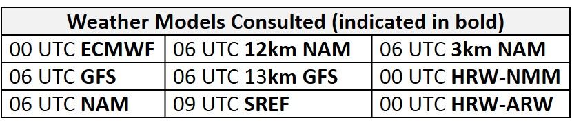
NWP Model Discussion
There is strong consensus between the weather models with the evolution of the synoptic pattern throughout the medium range period, which gives us confidence in a likely high ozone event starting as early as Friday and continuing through the end of the period. The axis of the upper level trough currently passing over the Great Lakes will reach the Mid-Atlantic by 06Z Thursday, before moving off the east coast by 00Z Friday. The departure of this feature will allow a strong upper-level ridge, currently building over the Great Plains, to push eastward on Friday. The ridge will encompass most of the eastern CONUS as its axis moves over the Mississippi River Valley around 12Z Friday. At upper levels, the center of high pressure will progress northeastward along the Ohio River Valley, moving directly over the NMA/CMA by 12Z Saturday. At mid-levels, the ridge will initially be centered over the Southeastern U.S./Gulf Coast, and the departure of the Great Lakes trough will allow it build north and east on Friday, pushing a weak frontal boundary from the SMA back northeastward across the CMA and NMA. The mid-level ridge will merge with the Bermuda High by roughly 12Z Saturday. This dome of high pressure will remain directly over the NMA through 12Z Sunday. At this time, a broad and shallow longwave trough over the Upper Midwest will push eastward, weakening as it moves through the Great Lakes, before deflecting to the northeast over the ridge by 00Z Monday. This upper level feature will flatten the ridge over the Mid-Atlantic late Sunday before the mid-level ridge strengthens again on Monday. At upper levels, the Mid-Atlantic ridge will merge with a broad ridge centered over the Plains on Monday, forming one large, broad ridge over essentially the entire CONUS. Under this upper level ridge, a shortwave trough will approach the Mid-Atlantic from the northwest on Monday.
The Dailies
Day 1 (Thursday): A low pressure system moving along the St. Lawrence River Valley will pull a weak cold front through the region on Thursday, bringing unsettled conditions to parts of the Mid-Atlantic. Periods of locally heavy rain across the NMA and CMA will gradually clear throughout the morning hours, with the possibility of another round of scattered showers and thunderstorms in the afternoon, due to the slowing of the cold front near the Atlantic coast. Mostly cloudy skies will partially clear by the afternoon, from west to east, as high pressure moves into the Ohio River Valley. In the SMA, periods of sun and clouds will allow temperatures to rise to above average values. The air quality models are responding to overnight precipitation and periodic cloud cover across the Mid-Atlantic as they develop a mix of Good/Moderate range ozone. As a result, the risk of an ozone exceedance will remain Slight.
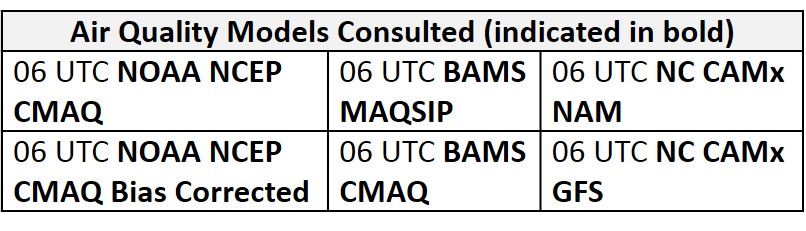
Day 2 (Friday): An extended poor air quality event will likely start on Friday as the upper-level ridge begins to build over the Mid-Atlantic. Sunny skies across the region will allow temperatures to rise above average values, with many locations reaching into the 90s °F. Surface high pressure centered over WV will promote weak surface winds throughout the region, with bay and sea breezes likely. The center of high pressure aloft will be off to the west, allowing for northwesterly back trajectories for the NMA. This is a key potentially limiting factor for locations west and north of the I-95 Corridor. Another factor to consider is the fact that the NMA and CMA will be weakly post-frontal, with Thursday’s weak cold front making it to the SMA early Friday, and then moving back northeastward during the day on Friday as the mid-level ridge builds northeastward into the Mid-Atlantic. This frontal movement raises questions about the air mass characteristics on Friday. The air quality models are responding to conditions favorable for ozone formation with widespread Moderate ozone with a few pockets of USG ozone across the region. The BAMS and the NC models develop isolated USG ozone in western PA, along the western coast of the Chesapeake Bay, and across the NC Piedmont. Notably, the models keep the area east of I-99 and north of I-76 in the Good to low Moderate range; these are the locations most susceptible to the effects of northwesterly flow aloft. The primary forecast questions for Friday will be how modified the air mass in place is, considering it should be relatively clean after Thursday’s widespread periods of precipitation and weak frontal passage, and the impact of the northwesterly transport. The risk of an ozone exceedance will increase to High on Friday, with a focus on western PA, which will be the first to feel the effects of the upper level ridge, as well as the BAL-DC corridor along the Bay, which will be susceptible to the impacts of the bay breeze.
Day 3 (Saturday): Multiple ozone exceedances seem likely on Saturday, as the upper-level ridge builds overhead. Surface high pressure lingering over the CMA will again promote sunny skies and weak surface winds. The strong ridge aloft will generate strong subsidence, with essentially no chance for optically thick clouds or thunderstorms. Temperatures will remain above average across the entire Mid-Atlantic with many locations reaching well into the 90s °F. Nearby high pressure will result in localized back trajectories (for PIT and RDU) although 36 hr back trajectories ending at 12Z for PHL are quicker than expected, sourcing form northern MI/southern ON. As the mid-level ridge builds in on Saturday, however, upper level transport will recirculate and shift weakly southward by the end of the day. The air quality models continue to increase regional ozone concentrations with USG ozone across much of the NMA and eastern CMA. In the SMA, the air quality models are holding back on USG ozone, possibly associated with a weak southerly component to the flow, due to the position of high pressure to the north. The BAMS models and the NC-GFS2 suggest that ozone will be the highest along the I-95 Corridor in the NMA and CMA, most likely due to sea/bay breeze development and calm surface winds inland. High risk of an ozone exceedance will continue on Saturday with a focus on the NMA and CMA.
Day 4-5 (Sunday-Monday): Persistent high pressure over the Mid-Atlantic will result in a scorching hot start to the month of July. On Sunday, temperatures will reach well into the 90s °F across most of the region as increasing humidity pushes heat indices past the century mark in many locations. Sunday will likely be the hottest day of the period. Sunny skies, localized back trajectories, and weak surface winds in the northern half of the region are promoting even higher ozone in the air quality models, with widespread USG and a few patches of Unhealthy ozone across the eastern NMA/CMA. The development of a sea/bay breeze across the eastern NMA/CMA will probably result in the highest ozone along the I-95 Corridor and surrounding locations. The only potentially limiting factors will be lower Sunday emissions (likely not much of a deterrent for locations directly along I-95), and weak southerly flow aloft and at the surface. Southerly flow has the ability to quickly clean things out, but the flow on Sunday and Monday looks weak and localized enough that it will likely exacerbate rising ozone, not reduce it. Across the southern half of the region, weak onshore flow and periods of sun and clouds are resulting in Good range ozone in the air quality models despite temperatures in the upper 90s °F. Once again, ozone conducive conditions will promote chances for multiple exceedances across the NMA and CMA, keeping the risk of an exceedance High.
Poor air quality will likely spill into the work week as oppressive conditions continue throughout the Mid-Atlantic on Monday. A low pressure system moving through ON will try to pull a weak cold front into the NMA sometime in the first half of the day, possibly resulting in scattered showers and thunderstorms. Increasing cloud cover throughout the day will keep temperatures a few degrees lower across most of the region, but it will probably feel just as hot as Sunday due to rising humidity. The development of clouds and precipitation will be the primary forecast question on Monday. At this point, they look to stay west of the I-95 Corridor through the late afternoon, keeping the chances for widespread ozone exceedances High.
-Enlow/Huff