

Medium Range Air Quality Outlook
Mid-Atlantic Region
Issued: Thursday, June 7, 2018
Valid: June 8-12 (Friday-Tuesday)
![]()

Summary
The risk of an ozone exceedance will remain High for Friday with a focus on the western NMA and the I-95 Corridor. Two features will impact the forecast as a weak cold front creeps southward into the NMA and mid-level high pressure builds over the Southeast. The southward push of the frontal boundary and the development of thunderstorms and associated cloud cover will be the determining factors in tomorrow’s air quality forecast. Weak surface winds and localized back trajectories will promote ozone formation across the NMA and CMA if thunderstorms hold off until after 00Z Saturday. A lingering cold front and the return of a humid air mass will promote unsettled conditions across portions of the Mid-Atlantic on Saturday. Widespread afternoon thunderstorms will impact the CMA but appear to be more scattered across the NMA. If thunderstorms do not impact locations in western PA and along the I-95 Corridor, localized back trajectories and weak surface winds could keep ozone concentrations elevated. Due to uncertainty in the precipitation forecast, the risk of an ozone exceedance will be Marginal with a focus in western PA and along the I-95 Corridor. Uncertainty remains in the forecast on Sunday but unsettled conditions appear likely. The frontal boundary lingering over the NMA will finally advance southward into the SMA promoting conditions less favorable for ozone production. The return of unsettled conditions and low Sunday emissions will diminish the risk of an ozone exceedance in the NMA and CMA. In the SMA, a shift to southwesterly flow and above average temperatures will result in a Marginal risk of an exceedance. Uncertainty in the details persist through Monday and Tuesday but conditions do not appear favorable for ozone formation. The risk of an ozone exceedance will drop to Slight for both days.
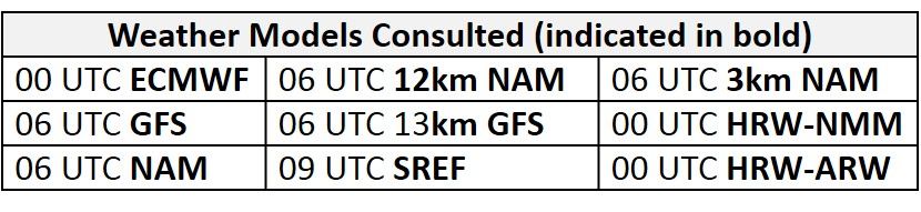
NWP Model Discussion
There continues to be a general consensus with the synoptic pattern throughout the medium range period. There is, however, some uncertainty with the strength and propagation of shortwave perturbations cresting the central US ridge on Friday that will impact the Mid-Atlantic throughout the weekend and into early next week. The upper level trough over the central US will encompass most of the US and southcentral Canada by 12Z Friday. The broad extent of this ridge will promote mid-level ridging to build over the southeast US and Mid-Atlantic regions on Friday that will likely persist through the weekend. Returning to upper levels, shortwave energy will crest the ridge on Friday but the models are not in agreement with the placement and track of these features as they propagate into the Midwest/Great Lakes region by 18Z Saturday. The GFS and NAM are similar bringing the shortwave through IA/MO and over the Mississippi/Ohio River Valley by 12Z Saturday. The GFS is slightly stronger, developing a more prominent wave of low pressure in the Midwest. The ECMWF varies as it pushes the shortwave energy more northward, over ND/MN by 18Z Friday before quickly moving across the Great Lakes by 18Z Saturday as it is influenced by a longwave trough over eastern Canada. The ECMWF then continues to merge this shortwave energy into the longwave trough, resulting in weak troughing over New England and the NMA by 00Z Sunday. The more progressive GFS and NAM push the shortwaves and associated wave of low pressure across the Ohio River Valley and into the NMA by 12Z Sunday. These differences between the models will impact the placement and southward push of a cold front that will stall in the NMA on Friday. The GFS and ECMWF solutions come into a closer agreement by 12Z Monday as the axis of the upper level ridge is pushed over the Mississippi River Valley by a longwave trough moving over the Northeastern US. Both models develop a wave of low pressure along the lingering frontal boundary across the Ohio River Valley. The solutions diverge again as the models disagree with the progression of this feature. The ECMWF develops a weak longwave over the Ohio River Valley by 18Z Monday that moves over the Mid-Atlantic by 00Z Wednesday. The GFS on the other hand only brings weak shortwave through the region on Tuesday.
The Dailies
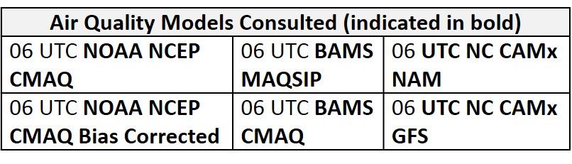
Day 1 (Friday): The risk of an ozone exceedance will remain High for Friday with a focus on the western NMA and the I-95 Corridor. Two features will impact the forecast as a weak cold front creeps southward into the NMA and mid-level high pressure builds over the Southeast. Surface high pressure will pass through the CMA during the overnight and morning hours promoting mostly sunny skies. The approaching cold front will increase cloud cover in the NMA but the extent of lower level cloud cover is in question. Precipitation along and ahead of the boundary is also an important forecast question. The NAM-suite of models are generally in agreement that scattered thunderstorms across western PA will hold off until 00Z Saturday. The GFS-13km develops more scattered thunderstorms across PA as early as 18Z Friday. Warm air advection will result in slightly above average temperatures for the entire Mid-Atlantic. Surface winds in the NMA and CMA will be calm overnight and shift to southwesterly in the morning hours. The air quality models are responding to ozone-friendly conditions as regional ozone continues to increase. The BAMS, NOAA and NC models all highlight western PA with elevated ozone. The BAMS-MAQSIP, NC-NAM1 and the NOAA model develop USG ozone in this region while the rest of the NC versions develop Unhealthy ozone. The BAMS models develop widespread Moderate ozone across the rest of the NMA and CMA. The more aggressive NC models blanket most of PA, WV and the I-95 Corridor under USG ozone. Weak surface winds and localized back trajectories will promote ozone formation across the NMA and CMA if thunderstorms hold off until after 00Z Saturday. The southward push of the frontal boundary and the development of thunderstorms and associated cloud cover will be the determining factors in tomorrow’s air quality forecast.
Day 2 (Saturday): A lingering cold front and the return of a humid air mass will promote unsettled conditions across portions of the Mid-Atlantic on Saturday. Mostly sunny skies in the SMA and lack of low/mid-level clouds in the CMA and NMA will allow temperatures to reach above average values. Widespread afternoon thunderstorms will impact the CMA but appear to be more scattered across the NMA. If thunderstorms do not impact locations in western PA and along the I-95 Corridor, localized back trajectories and weak surface winds could keep ozone concentrations elevated. In the SMA, high pressure building overhead will promote mostly sunny skies and above average temperatures, but weak onshore flow aloft and at the surface will take the edge off ozone. The air quality models maintain elevated regional ozone concentrations despite the arrival of unsettled conditions. The BAMS-MAQSIP, NC-NAM3 and NC-GFS3 models keep a few pockets of USG ozone across western PA and the I-95 Corridor possibly in response to lack of widespread precipitation ahead of the frontal boundary. The BAMS-CMAQ and the rest of the NC model maintain widespread Moderate ozone across the rest of the NMA and CMA. All of the models are in agreement that increasing onshore flow in the SMA will knock ozone into the low Moderate/upper Good range. Due to uncertainty in the precipitation forecast, the risk of an ozone exceedance will be Marginal with a focus in western PA and along the I-95 Corridor.
Day 3 (Sunday): Uncertainty remains in the forecast on Sunday but unsettled conditions appear likely. The frontal boundary lingering over the NMA will finally advance southward into the SMA promoting conditions less favorable for ozone production. It remains uncertain exactly where thunderstorms will occur across the region, but mostly cloudy skies and a cool, dry air mass following the frontal passage will drop temperatures to below average values in the NMA and CMA. The arrival of unsettled conditions is apparent in the air quality models as the majority of the models develop widespread Good ozone across the region. The BAMS and NC-GFS models keep a swath of Moderate ozone along I-81 in the CMA and SMA possibly in response to temperatures reaching into the 90s °F. The return of unsettled conditions and low Sunday emissions will diminish the risk of an ozone exceedance in the NMA and CMA. In the SMA, a shift to southwesterly flow and above average temperatures will result in a Marginal risk of an exceedance.
Day 4-5 (Monday-Tuesday): Uncertainty in the details persist through Monday and Tuesday but conditions do not appear favorable for ozone formation. Unsettled conditions appear likely across the SMA with scattered showers and thunderstorms possible each day. A considerably drier and cooler air mass will filter into the NMA and CMA resulting in below average temperatures on Monday that will near average values on Tuesday. The risk of an ozone exceedance will drop to Slight for both days.
-Enlow