Author Archives: William F. Ryan

Update on Wildfire Smoke in the eastern US

Updating yesterday’s post, it appears that the fire smoke from the large group of fires in western and central Canada is continuing to work its way into the eastern US and will impact the mid-Atlantic region in the next few days.

Yesterday’s polar orbiter images via MODIS shows the extent of the smoke:

image-download


This morning’s PM2.5 surface observation show high concentration in KY and beginning to increase at the high elevation monitor at Big Meadows, VA in Shenadoah NP.

pm-july1


Figure 1.  PM2.5 hourly concentrations at Big Meadows, and two monitors in KY, July 1.  Data courtesy of EPA AirNow.

Canadian Wildfires and US Air Quality, June 30, 2015

The long Western drought and the recent extremely hot and dry weather have resulted in widespread wildfires from Alaska, through the Pacific Northwest, and into Canada.  At this time, smoke from a group of wildfires centered in northern Alberta have begun to push southward into the United States.

Slide7  Figure 1.  Map of wildfire locations in Canada, courtesy of the Active Fire Mapping Program, http://activefiremaps.fs.fed.us/ (upper left). Visible image of northern Alberta from MODIS aboard Aqua, June 28, 2015 (lower right).

By yesterday, Monday, June 29, the smoke plume can be clearly seen across the upper Midwest (Figure 2). The questions of most interest are the future direction of the smoke and whether it will mix downward to the surface.  Smoke plumes from strong wildfires are typically lofted upward near their source and may remain well aloft, not interacting with the surface, for long periods.  As of this morning, surface PM2.5 observations show that some of the smoke has impacted ground level observations sites (Figures 3 and 5).  The future path of the smoke is related to the large scale weather pattern which features a trough of low pressure over the eastern US (Figure 4).  This means that the smoke in the upper Midwest will move in a counter-clockwise arc towards the east.  Upward motion over the Ohio River Valley and northward should keep the smoke well above the surface, but this cannot be said for areas of smoke that drift further south.  This analysis suggests that smoke will impact the southeastern  US on Wednesday and perhaps the mid-Atlantic on Thursday.


Slide8


Figure 2.  Visible satellite image from June 29, 2015.


Slide6


Figure 3.   AirNow Navigator PM2.5 observations, June 30.  Blue shaded area is the area of fire smoke currently observed by surface-based PM2.5 monitors.  The arrows are rough estimates of the expected track of the smoke plumes.  The dashed line tracks the northern path where upward motion is expected.  The red line tracks the southern path characterized by less upward motion and more likely surface impacts.


upaCNTR_500


Figure 4.  500 mb geopotential heights, winds and humidity, June 30, 2015.  Winds are roughly parallel to the isoheight lines.


Slide5


Figure 5.  Satellite estimated PM2.5 concentrations, June 29, 2015. http://www.star.nesdis.noaa.gov/smcd/spb/aq/index.php?product_id=2


Mid-Atlantic Medium Range Air Quality Discussion, Issued Sunday, June 28, 2015


Medium Range Air Quality Outlook  Mid-Atlantic Region

Issued: Sunday, June 28, 2015

Valid: June 29-July 3, 2015 (Monday – Friday)

Summary:

A large scale trough will remain over the mid-Atlantic through the medium rang period.  We will start with Good air quality in a cool, dry air mass Monday.  A humid air mass will return Tuesday, pushing particles to the Moderate range.  Clouds and a good chance of rain will keep ozone in the Good range.  By Wednesday, there is high uncertainty in the forecast models with respect to precipitation.  As a result, we will continue with a Moderate air quality forecast through the remainder of the period.

Discussion:

The forecast models (NAM, GFS, ECMWF) are in good agreement with respect to the large scale flow features but differ on the amount of precipitation and cloud cover beginning Tuesday and continuing for the remainder of the week.  These differences impact air quality forecasts with the cloudier and wetter solutions pointing more toward Good air quality through the week.

The upper level low exits QC late Monday with the overlying trough remaining more or less in place.  The large scale trough axis reaches OH by Wednesday.  Downstream of the trough are a collection of vorticity maxima which could, depending on their placement, induce rain and clouds beginning Tuesday and continuing through Friday.   The GFS is strongest of the models with respect to precipitation in the mid-Atlantic.  This forecast uses a blend of the GFS and ECMWF so that areas of Moderate air quality are likely beginning Tuesday.

On Monday, the surface low exits northern New England with weak high pressure over western VA.  Temperatures will be below average on Monday with dew points remaining in the 50’s F.  As a result, we expect Good air quality on Monday.

By Tuesday, a weak pressure gradient and rapidly increasing humidity will allow particle concentrations to reach into the lower Moderate range.  The forecast models differ with respect to chances of precipitation but we expect clouds and some rain to reach the I-95 Corridor by late afternoon.  This will keep ozone in the Good range at most locations. Although the operational NAM gives temperatures approaching 90 F, none of the other models, including the SREF, follow suit.

By Wednesday, a lee trough will set up east of the Appalachians.  Strong SW winds will modulate the accumulation of pollutants but we expect Moderate air quality due to limited clouds and continued high humidity.  A weak cold front is expected to reach the mid-Atlantic on Thursday morning, then stall across the southern mid-Atlantic before lifting northward on Friday as a wave develops to the west along the stalled boundary.  The forecast models are not in agreement on precipitation chances both Thursday and Friday.  Without a clear signal with respect to clouds and precipitation, we will continue with Moderate air quality both days.

-Ryan

Medium Range Air Quality Outlook Mid-Atlantic Region

Issued: Saturday, June 27, 2015

Valid: June 28-July 2, 2015 (Sunday – Thursday)

Summary:

Cooler than normal through Monday, then a warming trend that will push air quality into the Moderate by Tuesday.  Moderate air quality to continue Wednesday with an uncertain forecast for Thursday.  As we reach late June, with day lengths on the order of 15 hours and a high sun angle, any sunny day poses a risk for high ozone.  The highest ozone concentrations are expected Tuesday and Wednesday with clouds likely to arrive Thursday.

For the full Medium Range forecast discussion, please visit the PSAQFO forecasting blog at: http://psaqfo.psu.edu/blog

Discussion:

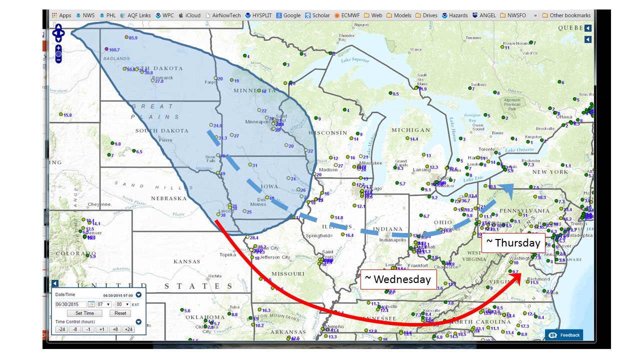
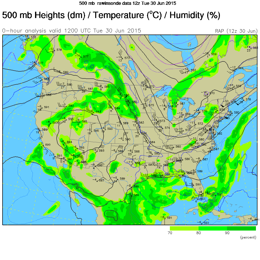
Good agreement between the forecast models (NAM, ECMWF and GFS) through Wednesday, with much less certainty for Thursday.  The main difference between the models is the depth of the eastern US trough on Wednesday.  This leads to differences in the possibility of precipitation late Wednesday and into Thursday.  The GFS has the stronger trough and thus more precipitation.  This discussion follows an average of the GFS and ECMWF after Tuesday.

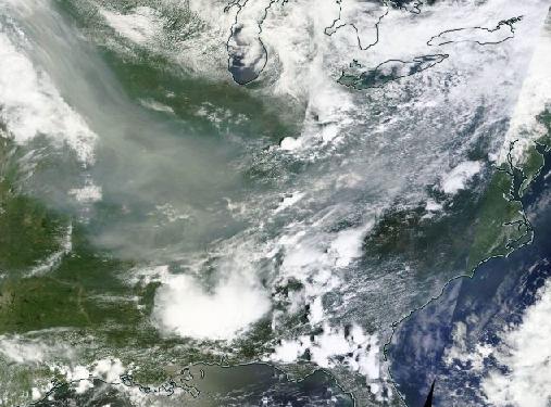
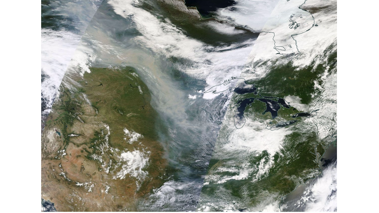
Low pressure over the mid-Atlantic is bringing heavy rain today.  The rain will end from SW to NE on Sunday with a lingering chance of rain until mid-morning in the northern mid-Atlantic.  The axis of the trough, and the closed low embedded in it, will reach NW PA by early Sunday and then move into southern QC on Monday.  The long wave eastern US trough will be reinforced by a strengthening short wave that will reach OH by Tuesday morning and then move off to QC by Thursday.  The GFS is stronger with this trough as noted above.

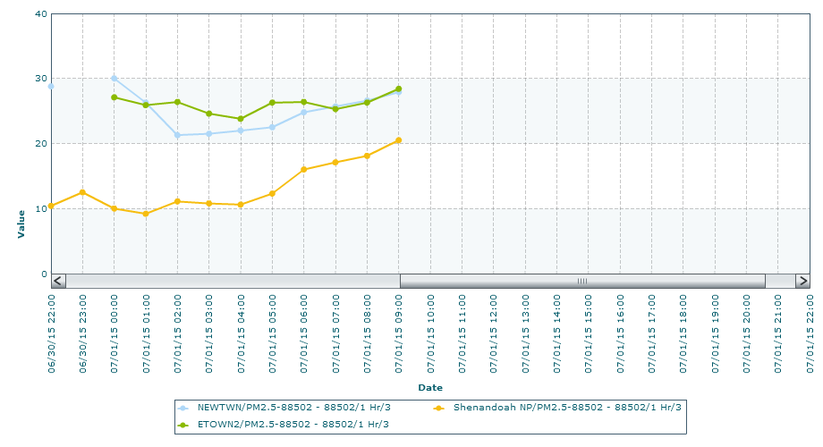
As low pressure rotates away to the NE on Sunday, most of the mid-Atlantic will be in a “dry slot” that will lead to mostly sunny skies.  With the upper level trough in place, cool air will keep temperatures in the 70’s F with falling dew points and strong westerly winds.  This will keep air quality in the Good range Sunday.  Similar conditions on Monday in terms of temperature and humidity but winds will decrease and shift to the SW.  This will allow ozone and fine particle concentrations to increase but we agree with the numerical air quality models that peak concentrations will remain in the upper Good range.

Temperatures will warm on Tuesday with steady SW flow.  The NAM is an outlier with respect to temperatures with a maximum temperature near 90 F on Tuesday.  We expect that mid-80’s F will be more likely.  In any event, sunny skies, along Corridor flow and a long late June day length will allow ozone and particles to reach the Moderate range with ozone as the leading pollutant.

The next cold front will be well to the west on Wednesday which will allow a continuation of Moderate air quality.  Frontal passage is expected early Thursday although, as we get into summer, fronts tend to move slower than expected for forecasts out 4-5 days.  There is also little consensus with respect to rain chances from the models.  The highest likelihood of rain Thursday is in the southern mid-Atlantic.  Good to low Moderate air quality is expected Thursday.

-Ryan

Mid-Atlantic Medium Range Air Quality Discussion, Issued Tuesday, July 8, 2014

Medium Range Air Quality Outlook
Mid-Atlantic Region

Issued: Tuesday, July 8, 2014
Valid: July 9- 13, 2014 (Wednesday-Sunday)

Summary:

A cold front will travel southeastward to southern PA by Wednesday night. Precipitation and cloud cover will keep ozone in the Good range yet westerly flow aloft and weak convergence will allow PM2.5 to reach the Moderate range in the northern Mid-Atlantic. High pressure will reach the northern Mid-Atlantic as the cold front moves southward. Cloudy skies and rain showers in the southern Mid-Atlantic and northwesterly flow and in the north will keep air quality in the Good range for most locations throughout the Mid-Atlantic. By Friday, the cold front will reverse its direction and move northward as a warm front. This will continue the rain for the southern region, keeping air quality in the Good range. The northern region will see sunny skies, increasing ozone to the Moderate range. PM2.5 will stay in the Good range. Saturday and Sunday will see Good air quality as the region will receive northerly/ northeasterly flow. There is a chance for Moderate ozone in the northern half of the region on Saturday.

Discussion:

The weather forecast models are in close agreement for this medium range forecast period. A weak upper level trough will pass through the Mid-Atlantic region until it flattens out and becomes zonal by Friday. The 06Z GFS and the 00Z ECMWF start to diverge on Saturday morning, however, when the ECMWF intensifies a shortwave over the Great Lakes region. The ECMWF then splits the shortwave into two separate lobes of energy that diverge over the Mid-Atlantic through Saturday. The GFS features a more zonal flow aloft on Saturday while the ECMWF develops a trough with a number of embedded shortwaves. After the passage of the shortwaves, the ECMWF and the GFS follow the same path once again starting Sunday night.

As a cold front approaches from the west, a pre-frontal trough will develop along the Mid-Atlantic. The front will move southeastward and reach VA overnight. Rain and thunderstorms will mainly pass through the southern part of the Mid-Atlantic, resulting in cleaner air quality conditions in these areas. Westerly flow aloft and convergence at the surface will allow PM2.5 to rise into the Moderate range for most locations in the northern Mid-Atlantic. Partly cloudy skies and rain showers should keep ozone in the upper Good range with the exception of scattered pockets of Moderate ozone along I-95.

On Thursday, the cold front will move southward to NC pushing the trough ahead of it. This will create a high chance for scattered rain and thunderstorms across the southern half of the Mid-Atlantic. High pressure will move in over the Great Lakes, resulting in mostly to partly sunny skies and northwesterly flow over the northern Mid-Atlantic with a slight chance of precipitation. Air quality will be reduced to the Good range for most locations with the exception of Moderate ozone along the northern I-95 Corridor.

The center of high pressure will move over upstate New York and then northeastward to the Atlantic Ocean during Friday. The northern Mid-Atlantic will stay dry while the southern Mid-Atlantic will continue the rainy weather as the cold front will move northward as a warm front. There is a chance for ozone to reach the Moderate range for most locations in the northern Mid-Atlantic due to increased sunshine. Cloudy skies and precipitation in the southern Mid-Atlantic will limit ozone to the Good range. PM2.5 should remain in the Good range for most locations due to northerly surface flow.

The warm front will skim the East Coast on Saturday creating a chance for scattered rain showers. Otherwise, there will be partly sunny skies and northeasterly flow aloft. As noted above, there is still uncertainty in the weekend’s precipitation forecast. Ozone is expected to reach the Moderate range primarily in the northern Mid-Atlantic while PM2.5 should remain in the Good range for most locations throughout the region. A cold front will approach from the west that will create rain and thunderstorms mainly for the second half of the day. Air quality is expected to be in the upper Good range.

-Catena/Ryan