Medium Range Air Quality Outlook
Mid-Atlantic Region
Issued: Wednesday, July 1, 2015
Valid: July 2-6, 2015 (Thursday – Monday)
![]()

Summary:
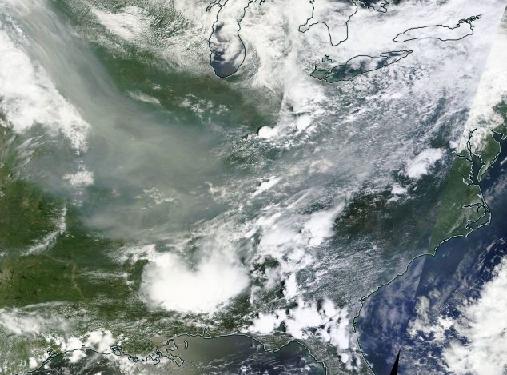
The arrival of a short-lived and narrow upper level ridge at the end of the medium range period will increase the chances for USG ozone to marginal on Sunday and Monday, mainly for the northern part of the region. For the beginning of the period, clouds and precipitation associated with a quasi-stationary frontal boundary oscillating between the Mason-Dixon Line and the VA/NC border will limit rising ozone, although there is uncertainty regarding the exact location of the heaviest rain and thickest clouds each day. The biggest question is the continuing fate of smoke from wildfires in Alaska and Canada, which is gradually moving eastward into the Mid-Atlantic this morning. Given the paucity of smoke forecast guidance, the impact of the smoke on surface PM2.5 concentrations is not certain. The smoke is expected to linger through at least Friday, however, contributing to Moderate PM2.5 conditions across the region.
Discussion:
The weather models are in general consensus on the synoptic features for the medium range period. The 06Z NAM, 06Z GFS, and 00Z ECMWF were consulted for this analysis, with an emphasis on the EC. The organized area of shortwaves over the ON/QC border that is pulling a cold front into the Mid-Atlantic today will form a closed low in central QC Thursday morning. This front is expected to stall on Thursday and oscillate northward and southward between the Mason-Dixon and the VA/NC border through Sunday. Shortwaves in the Plains will develop a series of waves that will ride along the quasi-stationary boundary. The forecast models are having trouble with the largest wave that will impact the region sometime on Friday. The GFS is much stronger with this feature and keeps it farther north, bringing the heaviest rain over MD and northern/central VA. The EC and NAM keep the heaviest rain farther south, mainly over NC and southern VA. WPC and the Mt Holly/PHL NWS office favor the EC solution, so we will follow that for this discussion. Over the Great Lakes, a weak ridge of high pressure will develop aloft and move eastward on Friday. This upper level ridge translates to an area of high pressure at the surface with its center over western NY on Friday morning and the Poconos on Saturday morning. Another wave of low pressure will ride along the quasi-stationary front and reach the Mid-Atlantic on Saturday morning. Saturday evening into Sunday morning, a more amplified upper level ridge of high pressure will develop between two closed lows, one over SK and the other over QC. The axis of this ridge will move eastward from central Canada to the Great Lakes on Sunday and then over the east coast on Monday. At the surface, the corresponding center of high pressure will stay to the north, sliding from southern ON on Sunday, to northern NY and New England and over the Atlantic Ocean on Monday, southeast of Cape Cod. The strong closed low over SK/MN will slide eastward to ON on Monday, helping to pull the stalled frontal boundary northward as a warm front.
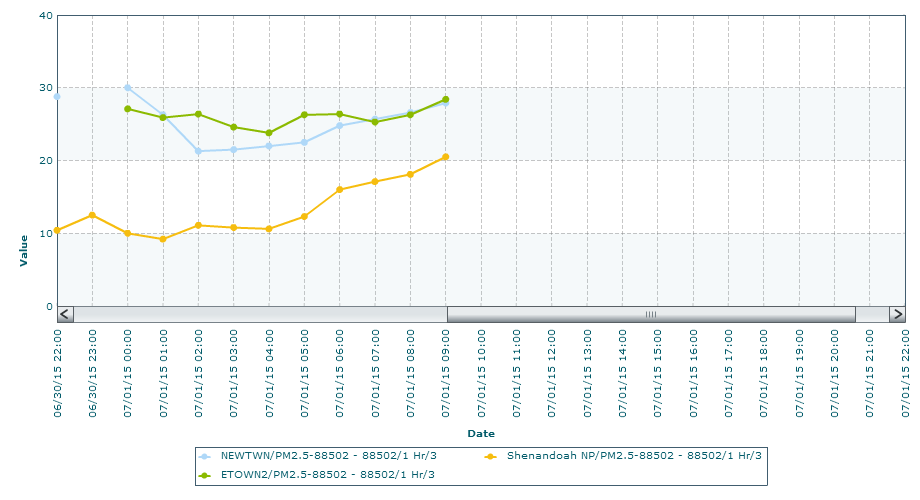
Uncertainty continues regarding the fate of the smoke from the wildfires in AK and Canada. Clouds have partially obscured the smoke on visible satellite imagery this morning, but it is visible over the northern Plains, Ohio River Valley (ORV), and into the Mid-Atlantic, including a plume parallel to the NJ and Delmarva coastline. The smoke is still clearly reaching the surface at many locations, such as the ORV and western PA, where hourly concentrations are as high as the low 20s to 30s ug/m3. In the absence of the NAAPS model, which still has not updated, we rely on the IDEA trajectories and the NOAA/EPA smoke model. Today’s GASP-based IDEA trajectories have not yet updated, but based on yesterday’s trajectories, the smoke currently over the Plains and ORV should continue to impact the entire Mid-Atlantic tomorrow. However, the NOAA/EPA smoke model shows a marked cut-off in smoke transport across the Mid-Atlantic tomorrow. Thus, back trajectories and persistence may be the best guidance for PM2.5 for the next several days, supplemented by GASP-based IDEA trajectories when they become available in the early afternoon.
The cold front moving through the northern Mid-Atlantic (NMA) today will weaken as it reaches southern VA on Thursday and stalls. Precipitation associated with this stalled frontal boundary will be light and stay confined to the central and southern Mid-Atlantic (CMA, SMA). Clouds and light winds will be widespread throughout most of the Mid-Atlantic. As a result, PM2.5 will be the leading pollutant on Thursday, with widespread locations reaching the Moderate range, mostly due to the impact of wildfire smoke. The NMA may see a few isolated locations of Moderate ozone as a weak area of high pressure over the Great Lakes will promote some clearing Thursday afternoon. The main forecast questions will be the impact of any smoke on ozone, as well as the air mass characteristics behind the cold front. Currently, the air behind the front looks very clean. There is a strong gradient in PM2.5 concentrations in particular, between for example the ORV and WI/MI/southeastern ON, due to the influence of the wildfire smoke. It is possible that the front will push the smoky air to the south, allowing cleaner air to flow into the NMA. If this is the case, ozone may be limited to the Good range while PM2.5 concentrations fall into the low Moderate range across the northern part of the region.
On Friday, surface high pressure over western NY will push the clouds and precipitation associated with the stalled frontal boundary south of the Mason-Dixon Line and will promote light winds and partly sunny skies in the NMA. Short back trajectories from western NY, coupled with at least some afternoon sun and light winds, will allow ozone to linger around the Good/Moderate threshold in the NMA. Overcast skies and precipitation in the CMA and SMA will most likely keep ozone in the Good range. The heaviest precipitation will likely be in southern VA and NC in the vicinity of the stalled frontal boundary. The threat of wildfire smoke will continue on Friday, but there is a great deal of uncertainty. PM2.5 concentrations will likely be the highest in areas with the lightest precipitation and lightest winds.
Saturday’s forecast is uncertain due to the differences between the models in the precipitation forecast. We are siding with the EC at this point, which keeps most of the region cloudy and rainy on Saturday, for continued Good ozone air quality. Heavy precipitation in the SMA overnight Friday into Saturday morning will have cleaned out the atmosphere, leading to more certainty of Good air quality in the SMA. The fate of the wildfire smoke will still need to be monitored for impacts to the region on Saturday. This, coupled with Independence Day firework celebrations, will be the main forecast question on Saturday. But most likely, Moderate PM2.5 conditions will continue.
Sunday and Monday look to be days of potentially deteriorating air quality as the narrow upper level ridge briefly moves overhead. Very warm weather, mostly sunny skies, light winds, short back trajectories, and a high solar zenith angle will promote rising ozone concentrations, mainly across the NMA. In particular, back trajectories are recirculating on Sunday, which bears watching. The BAMs and NC air quality models are responding to these conditions by increasing ozone to the upper Moderate range along and east of the I-95 Corridor on Sunday. The main forecast questions will be the impact of Sunday holiday weekend emissions and the progression of the warm front on Monday, which will promote clouds and precipitation along its path.
-DeBoe/Huff