Medium Range Air Quality Outlook
Mid-Atlantic Region
Issued: Monday, May 18, 2015
Valid: May 19-23, 2015 (Tuesday-Saturday)

Summary:
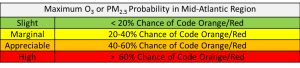
There is only a slight chance of Code Orange/Red air quality across the Mid-Atlantic through the medium range period. A strong cold front will gradually move through the region on Tuesday. Cloud cover and scattered precipitation associated with the front will limit ozone to the Good range, while particles will linger in the Moderate range in eastern portions of the region. The arrival of a clean, dry, and cool air mass behind the front will promote Good air quality for most of the Mid-Atlantic on Wednesday and Thursday, except for NC, where the stalled front will keep particles in the Moderate range. Although skies will be mostly to completely sunny on Friday and Saturday, reinforcement of the upper level trough over the region will limit any ozone increases to the low Moderate range.
Discussion:
The weather forecast models are in close agreement on the overall synoptic features of the medium range period. The 00Z ECMWF, 00 CMC, 06Z NAM, and 06Z GFS were consulted for this analysis. On Tuesday, an upper level trough over southern ON, reinforced by a closed low moving up from the northern Plains, will gradually progress eastward, pulling a cold front through the Mid-Atlantic at the surface. Mostly zonal flow over the Mid-Atlantic on Wednesday will give way to increased troughing as a shortwave from the Plains moves east and amplifies the eastern Canadian trough. The upper level trough over the eastern US will be further amplified on Friday as a closed low drops down from central ON and rotates around the axis of the trough over southern ON and QC. By Saturday, the GFS and EC take the closed low east over the Canadian Maritimes and begin to build an upper level ridge over the eastern US. The CMC has this same trend but is about 12 hours slower than the GFS and EC with the progression of the closed low. At the surface, Tuesday’s cold front will stall in the vicinity of southern NC through Thursday, while a secondary cold front will move into the northern Mid-Atlantic on Friday.
Tuesday will be warm and humid for most of the Mid-Atlantic as the slow-moving cold front gradually progresses across the region, reaching the I-95 Corridor around 00Z Wednesday. Mostly cloudy skies with scattered rain showers and thunderstorms will keep ozone in the Good range for most locations. Particle concentrations today are in the Moderate range along much of the I-95 Corridor, as the anticipated back door cold front has been slow to progress through NJ. On Tuesday, particles will linger in the Moderate range in the east in the humid, modified, and stagnant air mass.
A cold, dry, and clean air mass will build into most of the Mid-Atlantic on Wednesday. Breezy northwesterly surface winds and northwesterly flow aloft will promote Good air quality for most of the region. The exception will be NC, where clouds and humidity will linger in the vicinity of the stalled frontal boundary, for continued Moderate particle conditions.
Winds will subside on Thursday as a weak area of surface high pressure moves over the northern Mid-Atlantic. The air mass will remain cool, dry, and unmodified, with northwesterly transport from ON and the Great Lakes region, for continued Good to low Moderate air quality across the region.
Temperatures on Friday and Saturday will rebound slightly but remain at or slightly below average, with continued low humidity. Mostly sunny skies with strong late May sun will allow for some ozone production, but with an upper level trough in place and northwesterly transport from Canada – particularly on Saturday – any ozone increases will likely be limited to the low Moderate range. Particles will likely also remain Good to low Moderate in the dry air mass.
-Huff