Monthly Archives: June 2015

Mid-Atlantic Medium Range Air Quality Discussion, Issued Tuesday, June 30, 2015

Medium Range Air Quality Outlook
Mid-Atlantic Region

Issued: Tuesday, June 30, 2015
Valid: July 1 – 5, 2015 (Wednesday – Sunday)

MedRangeTable_20150701

MedRange_Cats_2

Summary:

The main features of the medium range period are the threat of smoke from Canadian and Alaskan wildfires and an oscillating frontal boundary that will bring daily clouds and precipitation to parts of the region. The best chances for USG ozone and upper Moderate PM2.5 are during the first part of the period, when mostly sunny skies and light winds will promote deteriorating air quality along the I-95 Corridor. The main question is the possible effect of the wildfire smoke, which is currently impacting surface air quality along the northern Plains. Westerly back trajectories are expected to transport wildfire smoke into the Mid-Atlantic as early as Wednesday. Depending on when the smoke reaches the Mid-Atlantic and how dense it is, another high ozone and PM2.5 day, comparable in extent to the exceedance day on June 11 but lower in magnitude, is possible. On Thursday, a cold front will approach the Mid-Atlantic, promoting scattered clouds and precipitation. This front is expected to stall in the central Mid-Atlantic Thursday evening and remain there as it oscillates between the Mason-Dixon Line and the VA/NC border for the rest of the medium range period. Behind this front, winds are expected to die down as surface high pressure builds in on Thursday and Friday, leading to continued chances for USG ozone in the northern Mid-Atlantic. More widespread clouds and precipitation and onshore surface winds on Saturday and Sunday decrease the chances for USG ozone to slight.

Discussion:

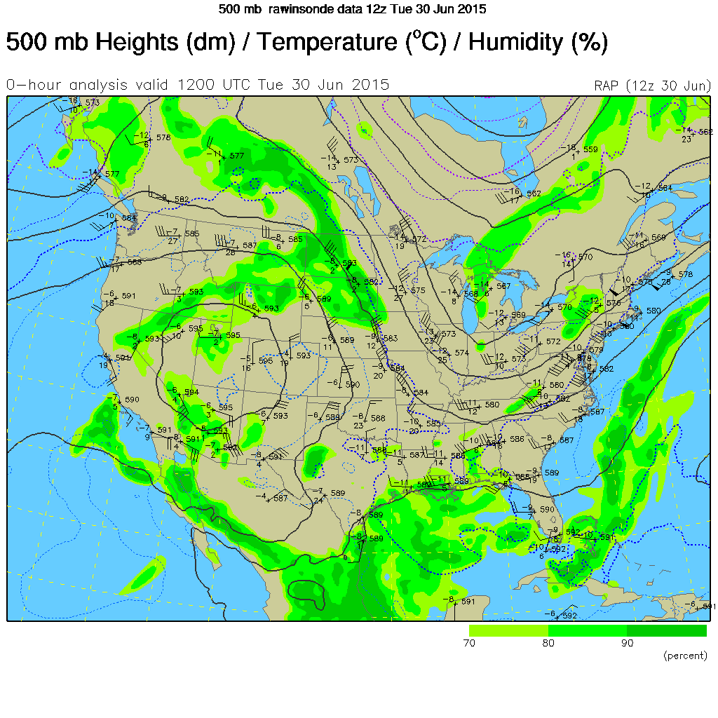
The 06Z NAM, 06Z GFS, and 00Z ECMWF were consulted for this analysis. WPC recommends a blend of the GFS and EC guidance with an emphasis on the GFS; as a result, we relied mainly on these two models for this analysis. The longwave trough in place over the eastern US will persist for the beginning of the medium range period. By the weekend, it will become less pronounced as a weak ridge moves over the Mid-Atlantic from the west. Today, shortwaves embedded within the longwave trough over the Great Lakes will help to pull several waves of low pressure at the surface northeastward into QC. By 06Z Thursday, the models form a closed low at 500 mb over central QC. As this feature slowly moves eastward, it will pull a cold front into the Mid-Atlantic on Wednesday into Thursday morning. This front is expected to stall in the same place that most fronts have stalled in recent weeks: in the vicinity of central VA/southern Delmarva. Subsequently, the stalled front will oscillate northward and southward between the Mason-Dixon Line and the VA/NC border through the rest of the period. Aloft, a weak ridge of high pressure will develop over the Great Lakes on Thursday evening and will move gradually eastward on Friday. At the surface, the center of this area of high pressure will move into the Great Lakes behind Wednesday’s cold front and move eastward, reaching western NY on Friday morning. Aloft, shortwaves will move southward from SK into the Plains on Thursday. They will become more organized and form a wave of low pressure in the central Plains on Thursday evening along the westward extension of the stalled frontal boundary. The wave of low pressure in the central Plains will move eastward, riding along the stalled frontal boundary, reaching the Mid-Atlantic on Saturday. More shortwaves will move overhead on Sunday as the front continue to oscillate in the central Mid-Atlantic (CMA). A weak ridge centered over the Great Lakes will move over the northern Mid-Atlantic on Sunday ahead the next approaching cold front.

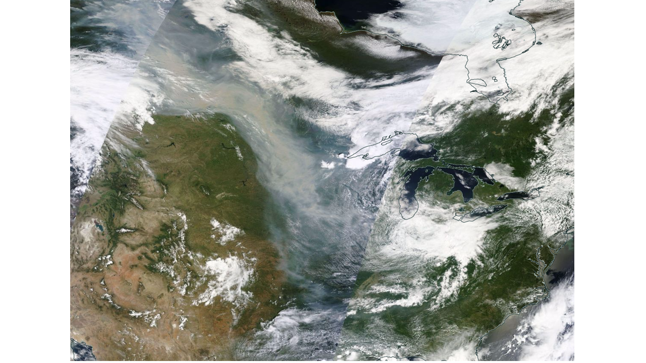
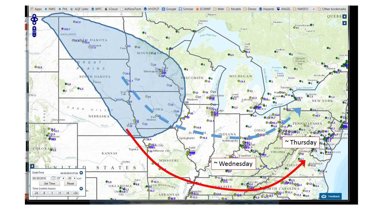
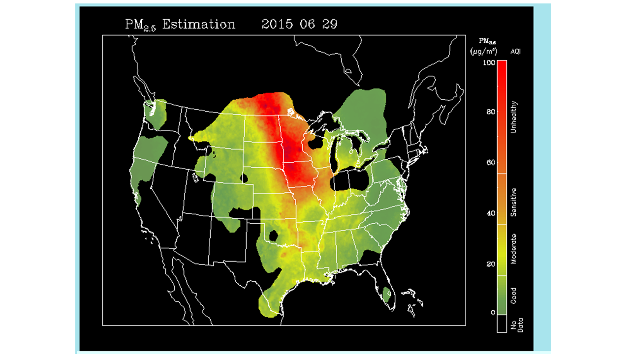
High PM2.5 is the main threat over the coming days as Canadian wildfire smoke continues to funnel into the Northern Plains. The smoke is evident this morning in visible satellite imagery, reaching as far south as MO, northern AR, eastern KY, and eastern TN. The smoke is definitely reaching the surface, as shown by this morning’s hourly concentration observations, which are as high as the mid 40 ug/m3 in parts of IA. Back trajectories tomorrow are from southern IL/IN, which is currently at the eastern most edge of the smoke plume. Trajectories from IDEA suggest that the densest smoke will arrive in the southern Mid-Atlantic (SMA; NC and VA) on Wednesday. In the absence of the NRL NAAPS model, which has not run since Friday, we will have to rely on the IDEA trajectories and the NOAA/EPA smoke model, which only provides 1-2 days of guidance. As a result, we expect that PM2.5 concentrations will rise substantially throughout the Mid-Atlantic by Thursday, but we will have to monitor the fate of the smoke closely over the next several days.

Given the continued repetitive and stagnant pattern through the medium range period, there is a chance for clouds and precipitation daily at least somewhere in the Mid-Atlantic. No day will be a washout, but with an oscillating frontal boundary persisting, showers and clouds will be present each day, mainly across the SMA. The main impact for air quality is that in locations where there is clearing, light surface winds and strong late June sun will set the stage for possible upper Moderate to isolated USG ozone. However, given the uncertainty in predicting the exact location of the oscillating frontal boundary, as well as the uncertain impacts of the wildfire smoke, the daily locations of the highest ozone and PM2.5 concentrations are impossible to predict at this point.

With a weak wave of surface low pressure centered over eastern PA on Wednesday morning, surface winds will be sustained throughout the day. A cold front will enter PA from the northwest in the afternoon, reaching roughly to central PA by 00Z Thursday. The models are not showing much precipitation associated with the frontal passage. Aside from possible pop-up showers in the afternoon, it will be mostly sunny in the Mid-Atlantic. A surface trough will extend southward from the center of low pressure along the I-95 Corridor and through eastern VA. Convergence along this trough axis coupled with extended periods of strong afternoon sun will push ozone concentrations into the Moderate range along and east of the I-95 Corridor, with isolated areas possibly approaching USG conditions. Chances for upper Moderate ozone will depend on how quickly ozone rises this afternoon and the possible impact of the smoke. Without a significant wind shift or period of precipitation, particle concentrations will likely rise from southwest to northeast due to transport of the Canadian wildfire smoke. Locations in SMA will probably see particles reach into the Moderate range by Wednesday afternoon.

On Thursday, the center of low pressure will move southward only to the Delmarva, with the cold front reaching westward across northern VA. Surface winds in the area will die down as the low pressure gradient weakens, making for stagnant air and the continued buildup of local and smoke-related PM2.5 throughout the day on Thursday, with widespread locations in the Moderate range. Along and south of the front, PM2.5 formation and buildup will be highest due to the more humid air mass and continued presence of smoke. Any showers forming as a result of convergence along the front will be light, isolated, and short lived, therefore not providing sufficient precipitation to clean out particles from the atmosphere by Friday. As a result, the highest PM2.5 concentrations will along and south of the front, with some areas reaching the upper Moderate range. While cloud cover is expected to increase overnight Wednesday into Thursday for areas along and south of the front, limiting ozone production, clear skies are still likely in PA and northern MD. These conditions will allow the threat for USG ozone to persist in the northern Mid-Atlantic (NMA) as wildfire smoke lingers and strong sun reaches the surface throughout the day. The main forecast questions will be the location of the front and the impact of smoke.

Friday may be the first day of decreasing PM2.5 concentrations as surface winds shift onshore and trajectories originate from the vicinity of Lake Huron. High pressure building over western NY will help keep the frontal boundary in southern VA, allowing for a mostly clear day throughout the central and northern Mid-Atlantic. The exception will be areas along and south of the front, where clouds and showers will persist. While light onshore winds and cleaner trajectories may help to limit particles on Friday, Independence Day fireworks celebrations will present a more localized threat to air quality, with at least scattered Moderate conditions likely continuing. Abundantly clear skies will continue to promote ozone formation for locations north of central VA, making for a Marginal chance for USG ozone conditions. The main forecast questions will be the continued impact of the wildfire smoke and varying emissions due to holiday travel.

Some hope for better air quality will arrive in the form of a surface wave from the Ohio River Valley on Saturday morning. As it approaches and skirts just south of PA before moving out to sea overnight, it will bring cleaner New England air as well as clouds and scattered rain showers to the entire Mid-Atlantic. However, this wave is a relatively weak one, and although the cloud cover will inhibit ozone formation, the resulting surface convergence may promote the buildup of PM2.5 for another day. Increased particle concentrations are especially probable at inland locations where onshore winds are not likely to help clean out the boundary layer. Sunday will see residual clouds and showers as the surface wave continues eastward and our frontal boundary persists in the central Mid-Atlantic. Clearing is likely in the NMA due to an area of strengthening high pressure in northern PA, possibly continuing the trend of high ozone concentrations in PA and MD.

-Huff/DeBoe/Eherts

Canadian Wildfires and US Air Quality, June 30, 2015

The long Western drought and the recent extremely hot and dry weather have resulted in widespread wildfires from Alaska, through the Pacific Northwest, and into Canada.  At this time, smoke from a group of wildfires centered in northern Alberta have begun to push southward into the United States.

Slide7  Figure 1.  Map of wildfire locations in Canada, courtesy of the Active Fire Mapping Program, http://activefiremaps.fs.fed.us/ (upper left). Visible image of northern Alberta from MODIS aboard Aqua, June 28, 2015 (lower right).

By yesterday, Monday, June 29, the smoke plume can be clearly seen across the upper Midwest (Figure 2). The questions of most interest are the future direction of the smoke and whether it will mix downward to the surface.  Smoke plumes from strong wildfires are typically lofted upward near their source and may remain well aloft, not interacting with the surface, for long periods.  As of this morning, surface PM2.5 observations show that some of the smoke has impacted ground level observations sites (Figures 3 and 5).  The future path of the smoke is related to the large scale weather pattern which features a trough of low pressure over the eastern US (Figure 4).  This means that the smoke in the upper Midwest will move in a counter-clockwise arc towards the east.  Upward motion over the Ohio River Valley and northward should keep the smoke well above the surface, but this cannot be said for areas of smoke that drift further south.  This analysis suggests that smoke will impact the southeastern  US on Wednesday and perhaps the mid-Atlantic on Thursday.


Slide8


Figure 2.  Visible satellite image from June 29, 2015.


Slide6


Figure 3.   AirNow Navigator PM2.5 observations, June 30.  Blue shaded area is the area of fire smoke currently observed by surface-based PM2.5 monitors.  The arrows are rough estimates of the expected track of the smoke plumes.  The dashed line tracks the northern path where upward motion is expected.  The red line tracks the southern path characterized by less upward motion and more likely surface impacts.


upaCNTR_500


Figure 4.  500 mb geopotential heights, winds and humidity, June 30, 2015.  Winds are roughly parallel to the isoheight lines.


Slide5


Figure 5.  Satellite estimated PM2.5 concentrations, June 29, 2015. http://www.star.nesdis.noaa.gov/smcd/spb/aq/index.php?product_id=2


Mid-Atlantic Medium Range Air Quality Discussion, Issued Monday, June 29, 2015

Medium Range Air Quality Outlook
Mid-Atlantic Region

Issued: Monday, June 29, 2015
Valid: June 30- July 4, 2015 (Tuesday – Saturday)

MedRangeTable_20150630

MedRange_Cats_2

Summary:

A progressive pattern will continue in the Northeast as the upper level trough persists, bringing a series of low pressure systems across the Mid-Atlantic. A frontal boundary moving into the region tomorrow will persist to varying degrees through the end of the medium range period, oscillating between PA and NC and promoting clouds and showers in its vicinity. Despite the chances for clouds and rain on Wednesday throughout the region, encroaching Canadian wildfire smoke makes the middle of the week the most likely day for USG conditions. The next possible exception in an otherwise clean atmosphere exists on Saturday, as there is model disagreement regarding an area of rain moving across the east coast. Depending on how far south this disturbance tracks, the northern Mid-Atlantic may see a day of increased ozone and PM2.5 concentrations.
Discussion:

The weather models are in generally close agreement on the overall synoptic features for the majority of the medium range period. The 06Z NAM, 06Z GFS, 00Z CMC, and 00Z ECMWF were consulted for this analysis. There is agreement regarding the placement of the upper level trough currently dominating east coast weather, with all models placing the base of the trough well into the southeastern US. Currently, there is a shortwave aloft just north of ME and a developing vorticity maximum in the base of the trough over the Ohio River Valley (ORV).
The evolution of this large scale trough, its embedded vorticity maxima, and the surface reflections of these in the form of a variety of complex boundaries are the critical forecast uncertainties throughout the medium range period. It is encouraging that the numerical models have come to a closer agreement on these features, however, the extent of clouds and precipitation in this kind of synoptic situation are difficult for the numerical models to accurately resolve beyond the short range (1-2 days). The other important uncertainty during the medium range period is the possibility of wildfire smoke encroaching on the mid-Atlantic, perhaps as early as Tuesday. More details on the smoke forecast, which may affect PM2.5 forecasts, are found below.

Although the forecast models are generally in agreement, by 12Z Thursday the NAM is a clear outlier, as it is the only model showing a very strong short wave developing over the Great Lakes. The CMC and EC develop a weaker shortwave over the NY/Canada border, while the GFS develops a very strong shortwave along the northern border of ME. Despite these differences among model solutions, they all bring clouds and precipitation to the Mid-Atlantic on Thursday.
An embedded “mini” ridge is developed near 00Z Friday but the model solutions diverge regarding its speed of advance with the EC the fastest. The models continue to diverge throughout the day Friday, providing significantly different upper level solutions by Saturday.
This is then reflected in different precipitation forecasts with the EC being the strongest, and furthest north of the solutions.

In the daily forecasts, a surface low pressure system currently in the Tennessee River Valley (TRV) will move northeastward into the NMA on Tuesday, and pull an accompanying warm front northward. This low pressure system will be weaker than Saturday’s storm, limiting scattered clouds and precipitation to the central and northern parts of the region. The higher resolution models, including the 06Z 4km “nested” NAM and 03Z SREF, agree on keeping the clouds and precipitation north of central VA. The precipitation in PA is likely to be widespread, while the precipitation in MD and northern VA is more likely to be convection. The nested NAM shows a disorganized line of convection just west of the I-95 corridor at 21Z. Locations in southern VA and NC will likely see clear skies for most of the day on Tuesday. The high solar zenith angle in conjunction with clear skies is favorable for ozone formation. The BAMS air quality models respond to this by showing areas of Moderate ozone in NC. Good air quality is expected throughout the region with the exception of locations in southern VA and NC which will see more sun.

Dense smoke from wildfires in AK and western Canada is currently in place over the Dakotas and the central Plains, reaching south into MO. This air in MO is expected to get incorporated into the circulation of the low pressure system in the TRV and flow into the Mid-Atlantic.
It is difficult to determine at what height the smoke will be when it arrives overhead. To the extent that any smoke is mixed downward into the boundary layer, as occurred earlier this month, PM2.5 and ozone will increase markedly into the Moderate range or worse. We will continue to monitor the fate of this pulse of smoke.

Wednesday will the day of most interest in the medium range period as above average temperatures, clear skies, light winds, and possible smoke may enhance ozone and PM2.5 production in the Mid-Atlantic. Ahead of an approaching cold front, there will be clearing throughout most of the region. Convergence along a diffuse boundary, expected to set up in the vicinity of the I-95 corridor Wednesday afternoon, may increase pollutant concentrations. The air quality models agree with this by showing Moderate ozone along the I-95 corridor. Back trajectories are expected to be from the TRV, suggesting that the smoke from the Canadian wildfires may impact the Mid-Atlantic on Wednesday. Again, if the smoke is mixed downward, we could see ozone and PM2.5 rise well into the Moderate range.

On Thursday, a cold front will move through the NMA in the morning, promoting widespread clouds and precipitation. The heaviest precipitation will be along the frontal boundary. As this front drifts southward, it will weaken and stall over the central Mid-Atlantic. This increases the chances that clouds and precipitation will be widespread throughout the region on Thursday, keeping air quality in the generally Good range. The smoke from the Canadian wildfires will still have to be monitored for impacts to the region on Thursday.

Friday and Saturday will be reminiscent of the past couple weeks as a frontal boundary stalls in central VA, promoting clouds and showers in its vicinity. Throughout the day Friday and into Saturday, discrepancies arise in the weather models regarding the location of this oscillating boundary, with the EC showing the heaviest and most northerly area of precipitation. The GFS, however, keeps the bulk of the clouds and showers south of MD. The WPC analysis shows a blend of these two solutions, placing the frontal boundary across northern VA and DE at 12Z Saturday. Depending on the location of this boundary, the NMA may see a day of clear skies, making for a beautiful 4th of July although clear skies and firework smoke may lead to a possible USG air quality day. However, at this time, it is too early to determine the background state of the atmosphere or make a call as to the placement of the front.

-DeBoe/Eherts/Ryan

Mid-Atlantic Medium Range Air Quality Discussion, Issued Sunday, June 28, 2015


Medium Range Air Quality Outlook  Mid-Atlantic Region

Issued: Sunday, June 28, 2015

Valid: June 29-July 3, 2015 (Monday – Friday)

Summary:

A large scale trough will remain over the mid-Atlantic through the medium rang period.  We will start with Good air quality in a cool, dry air mass Monday.  A humid air mass will return Tuesday, pushing particles to the Moderate range.  Clouds and a good chance of rain will keep ozone in the Good range.  By Wednesday, there is high uncertainty in the forecast models with respect to precipitation.  As a result, we will continue with a Moderate air quality forecast through the remainder of the period.

Discussion:

The forecast models (NAM, GFS, ECMWF) are in good agreement with respect to the large scale flow features but differ on the amount of precipitation and cloud cover beginning Tuesday and continuing for the remainder of the week.  These differences impact air quality forecasts with the cloudier and wetter solutions pointing more toward Good air quality through the week.

The upper level low exits QC late Monday with the overlying trough remaining more or less in place.  The large scale trough axis reaches OH by Wednesday.  Downstream of the trough are a collection of vorticity maxima which could, depending on their placement, induce rain and clouds beginning Tuesday and continuing through Friday.   The GFS is strongest of the models with respect to precipitation in the mid-Atlantic.  This forecast uses a blend of the GFS and ECMWF so that areas of Moderate air quality are likely beginning Tuesday.

On Monday, the surface low exits northern New England with weak high pressure over western VA.  Temperatures will be below average on Monday with dew points remaining in the 50’s F.  As a result, we expect Good air quality on Monday.

By Tuesday, a weak pressure gradient and rapidly increasing humidity will allow particle concentrations to reach into the lower Moderate range.  The forecast models differ with respect to chances of precipitation but we expect clouds and some rain to reach the I-95 Corridor by late afternoon.  This will keep ozone in the Good range at most locations. Although the operational NAM gives temperatures approaching 90 F, none of the other models, including the SREF, follow suit.

By Wednesday, a lee trough will set up east of the Appalachians.  Strong SW winds will modulate the accumulation of pollutants but we expect Moderate air quality due to limited clouds and continued high humidity.  A weak cold front is expected to reach the mid-Atlantic on Thursday morning, then stall across the southern mid-Atlantic before lifting northward on Friday as a wave develops to the west along the stalled boundary.  The forecast models are not in agreement on precipitation chances both Thursday and Friday.  Without a clear signal with respect to clouds and precipitation, we will continue with Moderate air quality both days.

-Ryan

Medium Range Air Quality Outlook Mid-Atlantic Region

Issued: Saturday, June 27, 2015

Valid: June 28-July 2, 2015 (Sunday – Thursday)

Summary:

Cooler than normal through Monday, then a warming trend that will push air quality into the Moderate by Tuesday.  Moderate air quality to continue Wednesday with an uncertain forecast for Thursday.  As we reach late June, with day lengths on the order of 15 hours and a high sun angle, any sunny day poses a risk for high ozone.  The highest ozone concentrations are expected Tuesday and Wednesday with clouds likely to arrive Thursday.

For the full Medium Range forecast discussion, please visit the PSAQFO forecasting blog at: http://psaqfo.psu.edu/blog

Discussion:

Good agreement between the forecast models (NAM, ECMWF and GFS) through Wednesday, with much less certainty for Thursday.  The main difference between the models is the depth of the eastern US trough on Wednesday.  This leads to differences in the possibility of precipitation late Wednesday and into Thursday.  The GFS has the stronger trough and thus more precipitation.  This discussion follows an average of the GFS and ECMWF after Tuesday.

Low pressure over the mid-Atlantic is bringing heavy rain today.  The rain will end from SW to NE on Sunday with a lingering chance of rain until mid-morning in the northern mid-Atlantic.  The axis of the trough, and the closed low embedded in it, will reach NW PA by early Sunday and then move into southern QC on Monday.  The long wave eastern US trough will be reinforced by a strengthening short wave that will reach OH by Tuesday morning and then move off to QC by Thursday.  The GFS is stronger with this trough as noted above.

As low pressure rotates away to the NE on Sunday, most of the mid-Atlantic will be in a “dry slot” that will lead to mostly sunny skies.  With the upper level trough in place, cool air will keep temperatures in the 70’s F with falling dew points and strong westerly winds.  This will keep air quality in the Good range Sunday.  Similar conditions on Monday in terms of temperature and humidity but winds will decrease and shift to the SW.  This will allow ozone and fine particle concentrations to increase but we agree with the numerical air quality models that peak concentrations will remain in the upper Good range.

Temperatures will warm on Tuesday with steady SW flow.  The NAM is an outlier with respect to temperatures with a maximum temperature near 90 F on Tuesday.  We expect that mid-80’s F will be more likely.  In any event, sunny skies, along Corridor flow and a long late June day length will allow ozone and particles to reach the Moderate range with ozone as the leading pollutant.

The next cold front will be well to the west on Wednesday which will allow a continuation of Moderate air quality.  Frontal passage is expected early Thursday although, as we get into summer, fronts tend to move slower than expected for forecasts out 4-5 days.  There is also little consensus with respect to rain chances from the models.  The highest likelihood of rain Thursday is in the southern mid-Atlantic.  Good to low Moderate air quality is expected Thursday.

-Ryan