Medium Range Air Quality Outlook
Mid-Atlantic Region
Issued: Friday, July 20, 2018
Valid: July 21-25 (Saturday-Wednesday)
![]()

Summary
A relentless stretch of widespread precipitation and strong onshore flow will keep a Slight risk of an ozone exceedance throughout the medium range period. The upper level longwave trough currently moving across the Midwest will park over the eastern U.S. on Saturday, where it will remain through the weekend, promoting widespread showers, cloudy skies, and onshore flow. Also on Saturday, a coastal low will move northward along the Atlantic Coast throughout the day, from eastern NC to the Delmarva. This low will generate heavy precipitation and strong surface winds along and east of the entire I-95 Corridor. To the west, the approaching Midwest low will bring precipitation into the western Mid-Atlantic. On Monday, the upper level low will weaken and begin to drop southward, as Bermuda high pressure in the Atlantic Ocean strengthens and pushes westward. The placement of the upper level trough and the strong Bermuda ridge will promote strong southerly flow throughout the rest of the medium range period. This flow pattern will bring a tropical-like, saturated air mass into the Mid-Atlantic that will promote widespread, locally heavy showers and thunderstorms each day. A combination of these conditions will ensure that Good air quality persists through the end of the Medium range period.
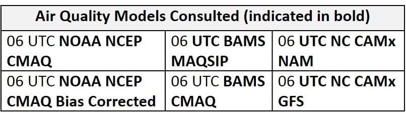
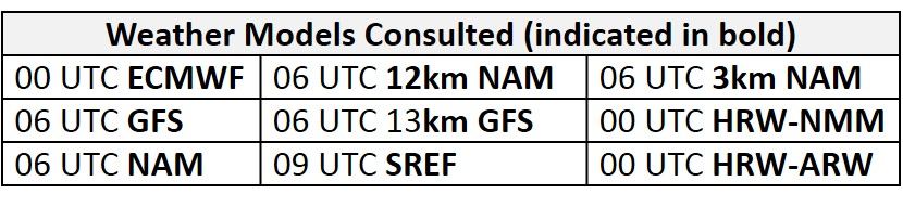
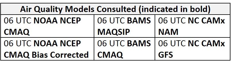
NWP Model Discussion
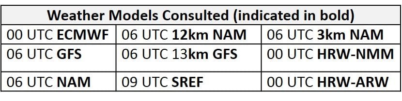

The weather models generally remain in agreement with the synoptic pattern throughout the medium range period with slight differences in the fine details. By 12Z Saturday, the upper level longwave trough currently moving over the Upper Midwest will close off over the southern Great Lakes (MI/IN/OH) with its associated trough extending to the southeast through the Ohio River Valley and Mid-Atlantic to the Southeast Atlantic coast. Shortwave perturbations in the base of the trough will be forced northward around the closed low as the system encounters a strong ridge of Bermuda high pressure over the Atlantic Ocean. This will result in the upper level trough stretching eastward from the closed low, across the NMA by 06Z Sunday. This feature will evolve into a broad upper level closed low/longwave trough over much of the eastern U.S. by 12Z Sunday. At this point, the models begin to diverge with the fine details of the forecast, with the ECMWF solution serving as middle ground between the GFS and NAM. The models are generally in agreement that the upper level closed low will open up around 00Z Monday as shortwave energy is ejected northward into upper level troughs passing through Canada. The eastern U.S. trough will continue to weaken throughout Monday as the strong Bermuda ridge builds eastward into New England, slowly pinching the top of the trough by 12Z Tuesday, nearly developing a cut off low over the eastern Gulf coast. The presence of the strong Bermuda ridge will keep the eastern U.S. trough in place as it gradually weakens through the end of the period, with shortwave energy continuously ejecting into the northern stream flow. This prolonged period with the Mid-Atlantic caught between the upper level trough and the Bermuda ridge will keep conditions unsettled throughout the medium range period.
The Dailies
Day 1 (Saturday): A long stretch of unsettled conditions will begin on Saturday. Two features will impact conditions across the Mid-Atlantic on Saturday. The first is a coastal low pushing northward up the Atlantic coast, which will promote heavy precipitation and strong surface winds along and east of the entire I-95 Corridor throughout the day. The second is the Great Lakes low pressure system slowly approaching the region from the west, which will bring precipitation into the western Mid-Atlantic in the latter half of the day. It is still not clear how widespread the precipitation will be for locations west of I-95, which will be between these two precipitation-generating systems. Nevertheless, the presence of the coastal low will promote strong onshore flow across the entire Mid-Atlantic, which will combine with cloudy skies and below average temperatures to keep ozone formation minimal. The air quality models are all in agreement that these conditions will yield widespread Good range ozone throughout the region. Widespread unsettled conditions and strong onshore flow will result in a Slight risk of an ozone exceedance on Saturday.
Day 2 (Sunday): Widespread unsettled conditions will persist on Sunday as the broad upper level closed low remains over the Mid-Atlantic. Stalled/dissipating frontal boundaries associated with the surface low pressure, now over the Ohio River Valley, will be draped across the CMA. The presence of these frontal boundaries and strong southerly mid-level flow bringing a saturated air mass into the region will promote widespread and locally heavy showers and thunderstorms across the entire Mid-Atlantic. Another day of widespread precipitation, mostly cloudy skies, and predominantly onshore flow will prevent significant ozone formation on Sunday. The air quality models are in agreement that these conditions will promote widespread Good ozone throughout most of the Mid-Atlantic. The BAMS models are hinting that a few locations in the SMA could see ozone creep into the upper Good/low Moderate range but precipitation and nearly onshore southwesterly flow should be enough to keep ozone formation limited. The risk of an ozone exceedance will remain Slight on Sunday.
Day 3 (Monday): Good air quality will persist into the work week as the Mid-Atlantic remains under the downstream half of the weakening upper level trough. The trough axis to the west and strong Bermuda ridge to the east will set the stage for a tropical-like air mass surging northward into the region on strong southerly flow. A saturated air mass overrunning lingering frontal boundaries across the CMA will promote another day of scattered showers and thunderstorms across the entire Mid-Atlantic. Widespread showers and thunderstorms may hold off until the afternoon across parts of the NMA. Despite conditions conducive for Good air quality, the air quality models are oddly increasing regional ozone. The BAMS models are the most aggressive with widespread Moderate across the NMA and CMA with pockets of upper Moderate across south-central PA and central MD. Given the conditions anticipated throughout the weekend and very strong southerly flow across the eastern half of the Mid-Atlantic, this upper Moderate ozone solution appears to be way overdone even if precipitation does hold off across central PA. The only reason we can see for the air quality models to generate higher ozone on Monday is possibly in response to the stalled frontal boundary just to the east of the Appalachian Mountains. The NC-GFS2 also develops pockets of Moderate ozone across the western half of the region, specifically in southwestern PA and western NC, possibly in response to back trajectories (northwesterly) being heavily influenced by the nearby dissipating low pressure system. For now, we are completely discounting these Moderate ozone predictions. Given another day of widespread unsettled conditions across the eastern U.S., in addition to strong onshore flow across most of the Mid-Atlantic, the risk of an ozone exceedance will remain Slight.
Day 4-5 (Tuesday-Wednesday): Good air quality will continue through the middle of the work week. The upper level trough will gradually weaken as it lingers over the eastern U.S., with the Bermuda ridge nearly stationary to the east, through Tuesday and Wednesday. These features will keep strong southerly flow over the Mid-Atlantic, which will continue to bring an abundance of moisture northward over a dissipating stationary boundary stalled across the central SMA and eastern CMA. This will generate widespread precipitation that will persist throughout the region on both Tuesday and Wednesday. Once again, widespread precipitation, mostly cloudy skies, and strong southerly flow will keep ozone formation minimal through the first half of the work week.
-Enlow/Huff