Author Archives: Amy Kathleen Huff

Recent Trends in Observed Ozone in the Mid-Atlantic and a Look Ahead to the 2016 Ozone Season

Beginning in 2013 and continuing into 2015 and 2015, there has been a “step-down” in peak observed ozone (O3) across the Mid-Atlantic region. As shown in Figure 1, the number of O3 exceedance days (observed 8-hour average O3 ≥ 76 ppbv) in the southeastern Pennsylvania forecast region (SEPA, which includes Philadelphia) dropped substantially in 2013-2015 compared to 2003-2012. The black horizontal lines in Figure 1 indicate the average number of days when observed 8-hour O3 was ≥ 76 ppbv during the periods 1997-2002 (39.3 days), 2003-2012 (19.0 days), and 2013-2015 (5.0 days). The initial “step-down” during the period 2003-2012 has been attributed to reductions in O3 precursors, primarily emissions of nitrogen oxides (NOx) from energy generating units (EGUs) in the eastern U.S associated with the so-called “NOx SIP Rule.” Another, temporary “step-down” in O3 precursor emissions and concentrations occurred during the Great Recession in 2009, when only 3 O3 exceedance days were observed in SEPA.

What is responsible for the recent “step-down” in observed O3? Meteorology likely plays a role. The Mid-Atlantic had a somewhat atypical weather pattern during the summers of 2013-2015, which limited the development of heat waves in June-August. Historically, most high O3 days in the Mid-Atlantic region were characterized by a “heat wave” synoptic weather pattern, featuring a “ridge” of high pressure aloft, slowly eastward migrating surface high pressure, westerly transport aloft from the Ohio River Valley, sunny skies, and maximum temperature (Tmax) ≥
90 °F. Fewer incidences of “heat wave” synoptic patterns in June-August for the past three summers have presumably impacted peak observed O3 levels. But a quick comparison of the total number of hot days (Tmax ≥ 90 °F), days with measureable precipitation, and O3 exceedances for the periods 1997-2002, 2003-2012, and 2013-2015 in SEPA suggests that weather is not the sole contributing factor to the recent “step-down” in observed O3. Figure 2 shows that the average number of days with Tmax ≥ 90 °F was essentially constant for the three periods (25-27 days), while the average number of days with measureable precipitation was roughly the same in 1997-2002 (45) and 2013-2015 (47) – slightly less than the average for 2003-2012 (52). In contrast, the average number of O3 exceedance days dropped from 39 in 1997-2002 to 19 in 2003-2012 (attributed to reductions in regional NOx associated with the NOx SIP Rule) to only 5 in 2013-2015. Thus, even though the overall synoptic weather pattern was somewhat atypical during June-August 2013-2015, there were a comparable number of hot and rain-free days compared to previous years. Based on these weather conditions alone, observed O3 during 2013-2015 would have been expected to be similar to previous years. But it was not – and research shows that upwind NOx emissions have been steadily declining in recent years. Thus, lower regional NOx emissions seem to be the primary driver of the recent “step-down” in observed O3.

So what can we expect from the 2016 O3 season? One thing seems certain – we will have more O3 exceedance days than previous years because U.S. EPA lowered the O3 National Ambient Air Quality Standard (NAAQS) from 75 to 70 ppbv. We estimate that this change will increase the number of exceedance days in SEPA by 2.5 to 3 times, relative to 2013-2015. So for example, in 2015, there were 18 days with observed 8-hour O3 ≥ 71 ppbv, compared to 8 days with observed 8-hour O3 ≥ 76 ppbv. If it’s an unusually hot and dry summer, we may see even more O3 exceedance days. So far, after a rash of early season exceedances across parts of western Pennsylvania and Virginia during late April, it’s been cool, rainy, and cloudy during the first three weeks of May. Climatologically, that should change as we close out May and move into the warmer days of June, when we expect O3 will be on the rise.

SEPA_O3_1997-2015
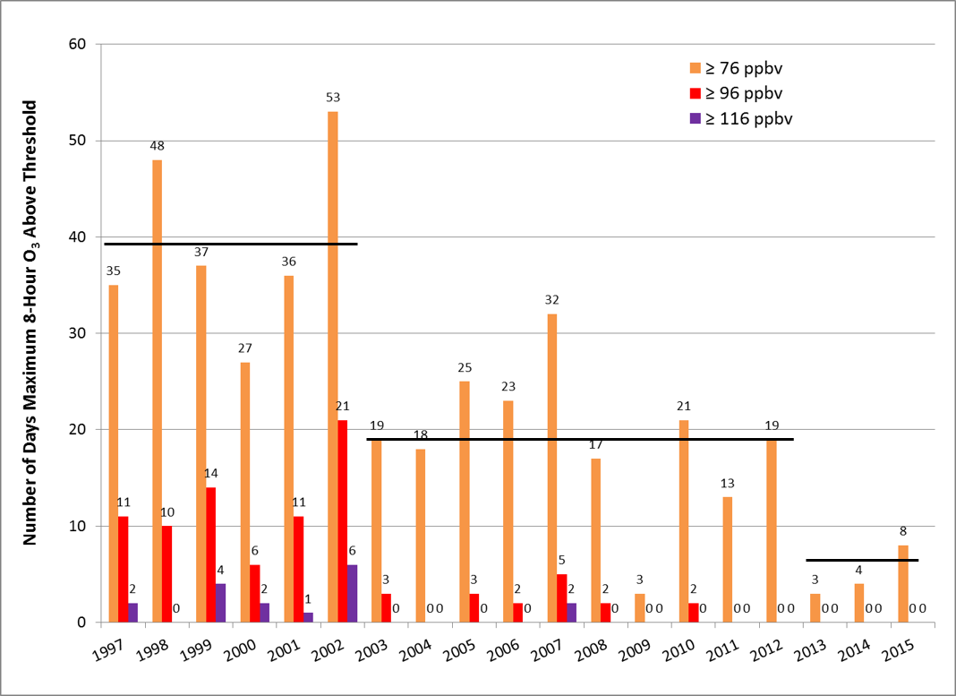
Figure 1.  Number of days when maximum observed 8-hour O3 exceeded thresholds of 115 ppbv (purple bars), 95 ppbv (red bars), and 75 ppbv (orange bars) in SEPA for 1997-2015.  The black lines indicate the average number of days with observed 8-hour O3 ≥ 76 ppbv for the period 1997-2002 (39.3 days), 2003-2012 (19.0 days), and 2013-2015 (5.0 days).

SEPA_Historical_Wx-O3_1997-2015
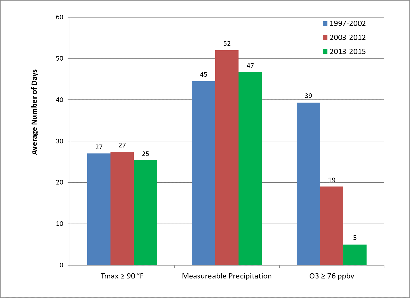
Figure 2.  Average number of days with Tmax ≥ 90 °F and measureable precipitation at KPHL, and observed 8-hour O3 ≥ 76 ppbv in SEPA for May 1 to September 30 during the periods 1997-2002 (blue bars), 2003-2012 (red bars), and 2013-2015 (green bars).

2016 Medium Range Discussions Will Begin May 23

Every year, we begin issuing our 5-day medium range air quality forecast discussions for the Mid-Atlantic region in the mid-May time period.   The medium range discussions are a great learning tool for our summer forecasting intern(s), so we usually wait to start issuing the discussions until the intern(s) begin working with us.  We also like to wait until the ozone season gets going, so we have something to discuss.  Our 2016 forecast intern, Matt Brown (check out his bio in the About Us section), began working with me today.  It’s looking like a fairly quiet week for air quality, so I’m going to get Matt oriented, and we’ll begin the forecast discussions next week.  The discussions will be similar to previous years, except we won’t be issuing them on the weekends this year, just on Mondays through Fridays.

Mid-Atlantic Medium Range Air Quality Discussion, Issued Sunday, August 9, 2015

Medium Range Air Quality Outlook
Mid-Atlantic Region

Issued: Sunday, August 9, 2015
Valid: August 10-14, 2015 (Monday – Friday)

MedRangeTable_20150810

MedRange_Cats_2

Summary:

There is high confidence in overall Good air quality through Thursday as a strong cold front approaches on Monday and moves eastward through the region on Tuesday. Pre-frontal clouds and rain will encroach into the region west to east early enough on Monday to limit ozone production across the Mid-Atlantic. Widespread rain will reach the western flank of the Mid-Atlantic overnight Monday into Tuesday morning, with a Tuesday morning washout for eastern parts of the region. Behind the front on Wednesday, the first true Canadian air mass in recent memory this summer will build in on northwesterly flow. This cool, dry, and clean air will keep ozone and particles in the Good range on Wednesday and Thursday. Temperatures will quickly rebound to average values on Friday as the center of high pressure settles over the region. There is uncertainty in the cloud cover forecast for the northern Mid-Atlantic on Friday, associated with the impacts of a back-door cold front. In the event that the front remains to the north on Friday, a return to Moderate ozone is expected under sunny skies and westerly transport.

Discussion:

The weather models are in very close consensus throughout most of the medium range period, but show some discrepancies on Friday regarding the next cold front to potentially impact the region. The 06Z GFS, 06Z NAM, and 00Z ECMWF were consulted for this analysis. Currently, a more zonal upper level flow is temporarily established over the Mid-Atlantic. An area of shortwave energy over the Northern Plains will get caught up in a trough digging out in northern ON, which is expected to dip into the Mid-Atlantic starting Monday night. The main area of shortwave energy in this trough over southern ON will be reflected at the surface as an area of low pressure located over Lake Ontario at 12Z Tuesday. At this time, the quickly amplifying upper level trough will reach well into GA. The frontal boundaries associated with the surface low – a warm front closely followed by a cold front – will sweep eastward across the Mid-Atlantic on Tuesday, preceded by widespread clouds and showers. 500 mb analyses for 12Z Wednesday show the large area of shortwave energy in this trough sprawled over the western New England/Canada border; 850 mb analyses show cooler, drier Canadian air spilling into the Mid-Atlantic behind the front; and surface analyses show a large area of surface high pressure centered over IA extending into the Mid-Atlantic. As the energy in the upper level trough begins to lift north- and eastward on Thursday, surface high pressure will continue to dominate the weather in the Mid-Atlantic. The trough will continue to lift northeastward on Friday and further allow surface high pressure to build into the region, but model differences arise regarding an approaching back-door cold front and its pre-frontal impacts. Both the EC and GFS show this front, but there are the usual timing differences. Whereas the faster GFS brings increasing cloudiness and rain showers to the northern Mid-Atlantic (NMA) on Friday ahead of the approaching front, the EC slows this boundary enough to keep Friday clear across the region. Due to the question of cloud cover, this discrepancy has an impact on the air quality forecast – however, since the day in question is the fifth day of the period, there is time for the models to come into closer agreement.

Monday will be a seasonably warm day across the region, with increasing cloudiness from west to east beginning around 15Z as the warm front lifts into the region, with the cold front close behind. The cloud cover will limit ozone to the Good range for most locations, with the exception being coastal areas of the Mid-Atlantic, where the clouds will reach last. This will allow those locations to see another day of mostly to partly sunny skies before the front reaches the Atlantic coast. Despite periods of sun along the coast, breezy southeasterly surface winds should be sufficient to limit ozone to the Good range for most locations. The air quality models are split this morning, with the NOAA model bringing ozone to the upper Moderate range along the northern I-95 Corridor (PHL to NYC) and mid-Moderate range to the south and west (BAL, DC, and PIT). In contrast, the BAMS and NCDENR models keep ozone in the Good range for tomorrow. The NOAA model has been overforecasting for the past several days, so we tend to discount its guidance for tomorrow, and go with generally Good ozone for the region. In the event that cloud cover is not as widespread as expected, some pockets of low-to-mid Moderate ozone are possible. Particles will increase across the western and central Mid-Atlantic, especially in PA, WV, and western MD, where humidity will be highest ahead of the cold front. Since rain is not expected until the overnight hours, PM2.5 will have ample time to rise into the Moderate range in the calm morning and light afternoon inland surface winds.

Rain will move eastward through the region overnight Monday into Tuesday morning, with the heaviest precipitation expected between 06-15Z Tuesday. Clouds will linger over the entire region throughout the day on Tuesday, inhibiting ozone production and keeping concentrations in the Good range. Particles will drop into the Good range as well, providing the strength of the rain is consistent across the region – as model guidance currently suggests. Southerly, onshore back trajectories lend confidence to this clean forecast for Tuesday.

The cold front will quickly move through the region. Wednesday will be a dry and mostly sunny day, with dew points dropping more than 10 °F compared to Tuesday. With the cold front now well to the east and out to sea, cool, dry, and clean Canadian air will filter into the region on northwesterly winds (at the surface and aloft) throughout the day. Because of this, the abundantly sunny skies and building surface high pressure will have little impact on the ozone forecast, and it will stay Good for another day. Particles should also remain in the Good range in response to the arrival of the clean and very dry summer air mass.

Surface high pressure centered over IL will continue to extend eastward and keep skies mostly clear over the Mid-Atlantic on Thursday. The Canadian air mass will have fully moved into the region at this point. Below average temperatures and fast, northerly back trajectories from interior ON will keep ozone and particles in the Good range across the eastern seaboard.

Temperatures will quickly rebound to average values on Friday as the upper level trough retreats northeastward. Atmospheric humidity will remain relatively low, however. There is some question about the arrival of the next cold front from the north. The GFS shows a faster approach of this cold front compared to the EC, and the GFS has pre-frontal cloud cover and light showers impacting the NMA on Friday. If this cloudy forecast does not verify, Moderate ozone seems likely, given a shift to westerly transport at the surface and aloft. However, the air mass over the Mid-Atlantic will still be sufficiently clean and unmodified to limit rising ozone to the low-to-mid Moderate range. Particles may increase into the Moderate range at scattered western locations due to westerly transport from the Ohio River Valley, but persistent low humidity will keep most locations in the Good range.

– Eherts/Huff

Mid-Atlantic Medium Range Air Quality Discussion, Issued Saturday, August 8, 2015

Medium Range Air Quality Outlook
Mid-Atlantic Region

Issued: Saturday, August 8, 2015
Valid: August 9-13, 2015 (Sunday – Thursday)

MedRangeTable_20150809

MedRange_Cats_2

Summary:

Overall Good air quality is expected throughout most of the medium range period as a strong cold front approaches on Monday and passes through the region on Tuesday. Mostly sunny skies and light northeasterly surface winds on Sunday will allow for Moderate ozone at the usual areas along and downwind (west) of the I-95 Corridor and in southwestern PA. Although lower Sunday emissions should keep rising ozone in the Moderate range, there is a Marginal chance for isolated USG ozone just to the west of I-95; as we saw yesterday, light northeasterly surface winds can promote isolated pockets of locally high ozone production in the afternoon. Particles will linger in the Moderate range in the western Mid-Atlantic, where easterly winds will be the lightest and humidity will be the highest. Monday will be an increasingly cloudy and breezy day as a warm front lifts northward, with the bulk of the pre-frontal rain sweeping eastward through the region on Tuesday. A seasonably cool, dry, and clean air mass is expected to arrive behind the front for Wednesday and Thursday, for Good air quality.

Discussion:

The weather models have come into closer agreement since yesterday, and are in very close consensus throughout the medium range period. The 06Z GFS, 06Z NAM, and 00Z ECMWF were consulted for this analysis. Currently, a large upper level ridge is well established with its axis through the Mississippi River Valley, and its northeasterly edge is reaching into the Mid-Atlantic. The ridge will swiftly recoil back out of the Mid-Atlantic as areas of disorganized shortwave energy crest the ridge and impact the Northeast, keeping scattered clouds and showers in the forecast for Sunday. Large shortwaves over northern ON will begin to dig out a large upper level trough on Sunday afternoon, reflected at the surface via a widespread area of low pressure. As this low pressure gradient strengthens and moves eastward, it will establish an extensive frontal boundary that will stretch from the James Bay to IA by Monday morning. Clusters of small short waves in the base of the trough will promote some cloud cover and showers in the Mid-Atlantic on Monday as a warm front moves northward at the surface. More widespread, heavy, pre-frontal showers will begin later in the day as the cold front associated with the Canadian low approaches. As the trough slowly moves eastward, shortwave energy in its base will continue to promote widespread clouds and rain along the frontal boundary on the east coast through Wednesday morning. Skies will clear quickly behind the front on Wednesday as cooler, drier Canadian air filters into the region on northwesterly winds.

Sunday will be a day of scattered cloud cover throughout the Mid-Atlantic as an unsettled area of dilute shortwaves moves overhead, with the thickest clouds expected along a north-south axis through central PA to central VA. The high-res weather models are resolving areas of light scattered rain showers in areas of central PA, MD, and VA later in the day. The usual areas of concern along and downwind of the I-95 Corridor and in southwestern PA will continue to see mostly sunny skies, however, and therefore Moderate ozone. Light easterly surface winds will push the bulk of the emissions just to the west of I-95, placing the areas of highest ozone around the DC and Baltimore metropolitan areas, which is supported by the air quality models. Due to the lower Sunday emissions, ozone is not expected to rise higher than the Moderate range, although there is a Marginal chance for isolated USG ozone just west of I-95, given the third day in a row of light northeasterly surface winds and mostly sunny skies. Particles will follow a similar pattern, with Moderate concentrations likely in the western part of the Mid-Atlantic due to increasing humidity and lighter inland winds.

A southerly wind shift on Monday as a warm front lifts northward through the region ahead of an approaching cold front will increase humidity, and therefore PM2.5, west of the I-95 Corridor. Ozone, on the other hand, will be inhibited due to mostly cloudy skies moving from west to east. Along and east of I-95, where the clouds will reach last, the southerly winds should be sufficiently breezy and onshore to hinder ozone formation and buildup. Faster, northerly back trajectories lend confidence to the Good ozone forecast.

The cold front moving through the region on Tuesday is substantial, and will generate widespread clouds and precipitation. Despite analyzed areas of Moderate ozone in the air quality models in southern MD and the surrounding areas on Tuesday, the long-lasting and widespread nature of the clouds and precipitation suggests this guidance is overdone. The rain is expected to move gradually westward across the region starting late Monday night and continue through early Wednesday morning. This leaves little opportunity for ozone to form, especially considering the onshore looping back trajectories. In areas where only light rain falls, the high pre-frontal humidity will allow pockets of Moderate PM2.5 to form, particularly in the western Mid-Atlantic.

Wednesday will be a calm and sunny post-frontal day in the CMA and SMA, while clouds may return to the NMA after a brief period of morning sun. The Canadian air mass behind the front is expected to be cool, dry, and clean, limiting ozone to the Good range across the region. By 12Z Wednesday, the southern extent of the cold front is expected to be draped over the eastern Carolinas. Along and just behind this frontal boundary, ozone will be limited by the clouds, while particles will linger in the Moderate range until the front fully clears the region.

By Thursday, the upper level trough will dip to the FL/GA border, with the ridge in the west reaching well into AB. A large area of high pressure will build eastward into the Mid-Atlantic, with abundantly clear skies expected over the entire region. Despite this, air quality likely will rise just barely into the Moderate range – if at all – due to the continuing clean air mass, dry air, below average temperatures, and fast back trajectories from the James Bay.

– Eherts/Huff

PSAQFO Student Meteorologist Lexie Herdt in the News Again

Lexie Herdt, recent PSU Meteorology graduate and summer forecasting intern with the PSAQFO, was featured in today’s edition of the Philadelphia Inquirer newspaper. Lexie (below) worked with Dr. Amy Huff and Bill Ryan during summer 2014, conducting research to update an ozone statistical model for Philadelphia. Her work was funded through a fellowship with the National Science Foundation’s prestigious Research Experience for Undergraduates (REU) program. This summer, she has been verifying the performance of her model as guidance for operational ozone forecasts for the Philadelphia metropolitan area. Lexie is off to Texas Tech University in few weeks to begin a MS program. Congratulations Lexie!

Lexie_Inquie