Author Archives: Amy Kathleen Huff

Mid-Atlantic Medium Range Air Quality Discussion, Issued Wednesday, June 22, 2016

Medium Range Air Quality Outlook
Mid-Atlantic Region

Issued: Wednesday, June 22, 2016
Valid: June 23-27, 2016 (Thursday-Monday)

Daily_MedRange_Table_20160623

New Med Range Categories

Summary:

Synoptic conditions are still conducive for a possible ozone event this weekend into Monday, but the setup is not as optimal today, making widespread ozone exceedances less likely, but chances still remain for isolated USG ozone along the I-95 Corridor. On Thursday, the majority of the Mid-Atlantic will experience widespread clouds and precipitation as a wave of low pressure moves through from west to east, making the chance for an ozone exceedance Slight.
High pressure will build back into the region from the north on Friday, allowing skies to clear and surface winds to subside. Northwesterly back trajectories and temperatures only reaching the low 80s °F should be sufficient to limit ozone production, with the chances for an exceedance only rising to Marginal. An upper level ridge will build eastward over the region Saturday and Sunday, but its advancement will be impeded by the remnants of Thursday’s wave’s vorticity, which will spin offshore as a weakly organized circulation. There is a trend today toward keeping this feature offshore through the weekend and moving it back toward the coast on Monday. This, along with the position of the surface high during the weekend, is shifting back trajectories more strongly onshore through the end of the period. As a result, classic conditions for a high ozone event will not be in place, but isolated exceedances along I-95 in particular are still likely, especially on Sunday and Monday. The main question for Monday focuses on organized precipitation forming ahead of the next cold front, which the forecast models show extending across the entire Mid-Atlantic from west to east, reaching I-95 by 00Z. At this point, locations along and east of I-95 may see enough sun for an additional day of isolated USG ozone. Therefore, the chances for an ozone exceedance are Appreciable on Saturday-Monday.

Discussion:

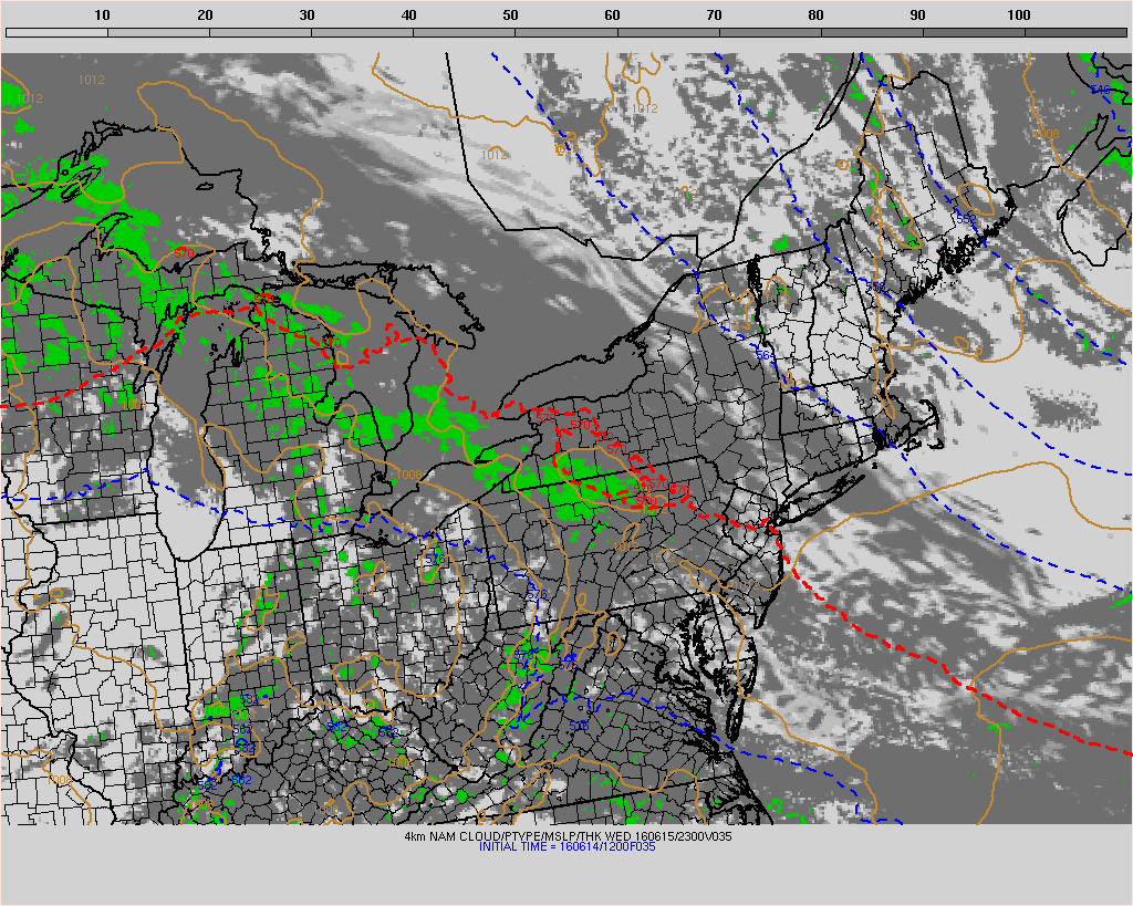
The weather forecast models are in close agreement regarding the synoptic pattern through the medium range, with only slight differences at the end of the medium range, except for the NAM, which is an outlier for the entire period. The models consulted for this analysis were the 06Z NAM and GFS and 00Z ECMWF. A wave of low pressure initiated aloft today will ride the front currently draped across the central Mid-Atlantic near the Mason-Dixon Line, reaching western PA/WV by early Thursday morning. The wave will pull the stationary front slightly northward as a warm front, to the vicinity of central PA/NJ. The GFS and EC are in consensus today with the placement of this front and its associated precipitation, showing the heaviest precipitation falling across the northern and central Mid-Atlantic through 12Z. By the afternoon, the heaviest precipitation will push southward across the central Mid-Atlantic. High pressure building across the northern Plains and southern ON on Thursday ahead of an amplifying upper level ridge centered over the Plains will shift southeastward towards the northern Mid-Atlantic on Friday, forcing the front and its surface low southward into NC. This ridge is tracking slightly slower in today’s guidance, with its eastern edge reaching the western Mid-Atlantic by 12Z Saturday and remaining in place until Saturday afternoon, when it finally shifts further eastward and covers the entire Mid-Atlantic through the weekend. It appears the main reason the upper level ridge is slower to build over the Mid-Atlantic is because the EC, and GFS to a lesser extent, holds onto Thursday’s wave’s shortwave energy and keeps it organized offshore, over the Atlantic before bringing it back along the coast on Monday. The main impact of this feature may be to promote onshore flow for Sunday and Monday. A mid-level ridge will hook up with the Bermuda High on Saturday, and remain in place through early Monday. A potent upper shortwave passing to the north of the Great Lakes on Monday will dig out a weak trough that will pull a cold front to the eastern Ohio River Valley, but the GFS and EC diverge slightly in the strength of the trough and its associated front. The GFS has a more compact upper level trough while the EC’s trough is more spread out and diffuse with the associated vorticity. This results in a faster progression of the cold front for the GFS, but the differences are relatively minor and expected with a feature that is 5 days away. Despite the timing differences, both the GFS and EC develop a strong line of precipitation ahead of the front that moves into the Mid-Atlantic on Monday from west to east, reaching just west of the I-95 Corridor by 00Z.

Rain will arrive in the western Mid-Atlantic overnight tonight and work its way eastward across the northern and central Mid-Atlantic through Thursday morning. In the afternoon, the heaviest precipitation will shift southward, as diurnal heating and outflow from the morning’s precipitation fire up thunderstorms across the central Mid-Atlantic. It still appears that NC will be spared of the clouds and precipitation associated with this system through Thursday, with intense afternoon sunshine and temperatures into the 90S °F. The 06Z air quality models, however, only show Moderate ozone levels across NC, with the rest of the Mid-Atlantic well into the Good range due to persistent cloud cover and precipitation. Therefore, the chance of an ozone exceedance will remain Slight for Thursday.

The northern Mid-Atlantic will clear on Friday as surface high pressure builds southeastward from southern ON, pushing the cold front southward into NC by 12Z Friday. Lingering instability showers are possible across the central Mid-Atlantic during the morning, with heavier rain and thunderstorms developing throughout the southern Mid-Atlantic along and ahead of the front. The mid-levels will cool slightly across the northern Mid-Atlantic in response to the frontal passage, moderating temperatures slightly, but we have seen recently that temperatures in the low 80s °F have been more than sufficient for ozone levels to rise along the I-95 Corridor, assuming sufficient stagnation. 06Z GFS back trajectories for the I-95 Corridor now show substantial northwesterly flow from the Great Lakes region, which should be relatively clean. Nevertheless, full sun and diminishing surface winds will allow for ozone formation. The air quality models have Moderate ozone for the I-95 Corridor. Taking these factors into consideration, the chance for an ozone exceedance will rise to Marginal for locations along the I-95 Corridor.

Saturday and Sunday continue to be potential days of interest for the Mid-Atlantic, as an amplifying upper level ridge over the Plains on Friday will move eastward on Saturday, and engulf the entire Mid-Atlantic by 12Z Sunday. However, given the slower advancement of the ridge and questions about the possible weak closed circulation aloft along the Mid-Atlantic coast, the setup is looking less optimal than it did yesterday. Weak troughiness will linger over the region on Saturday morning before the upper level ridge fully builds in on Sunday.

On Saturday, the mid-level ridge will strengthen over the eastern U.S. and hook up with the Bermuda High. By Sunday, surface high pressure will move directly over PHL. Although the track of the upper level ridge is slightly slower in today’s guidance, it will be close enough to Mid-Atlantic on Saturday for its influence to be felt, with abundant sunshine, subsiding winds, and a warming trend expected across the forecast region. The main caveat to this is a shift to onshore flow aloft induced by the circulation around the approaching surface high, which could keep ozone out of the USG range. On Saturday, back trajectories for I-95 show transport from Cape Cod and southern QC, which shift more easterly on Sunday. The current air quality model guidance still does not resolve any USG ozone within the Mid-Atlantic on Saturday, but on Sunday, the BAMS and NC models all have an area of USG ozone over northern NJ and upper Moderate along and west of I-95. At this point, widespread USG ozone does not seem likely, but isolated ozone exceedances are very possible. As a result, the chance for an ozone exceedance will rise to Appreciable for both Saturday and Sunday.

There is uncertainty in Monday’s forecast due to the possible influence of shortwave energy from Thursday’s system positioned off the Mid Atlantic coast, as well as widespread precipitation forming ahead of the next cold front. The GFS and EC both convincingly show an organized band of precipitation reaching across most of the region throughout the day. However, at this point, the I-95 Corridor looks to remain clear through 00Z Tuesday. In addition, weak cold fronts during this time of the year often have the tendency to slow down as they encounter warm air masses like the one that will likely be in place across the Mid-Atlantic on Monday. If the front does indeed slow down, then locations along the I-95 Corridor could experience another day of intense afternoon sunshine, subsidence, and light surface winds. There is also the question of the lingering shortwave energy offshore, which the EC pulls back westward during the afternoon and could potentially clean out locations along the I-95 Corridor regardless of whether the front reaches them or not. Back trajectories for the I-95 Corridor show a shift more south/southeasterly flow, which would certainly limit ozone production. Given the uncertainty, the chance for an ozone exceedance will remain Appreciable, mainly for the I-95 Corridor.

-Brown/Huff

Isolated Ozone Exceedance in Philadelphia Metro Area on June 15: Is It Time to Seriously Consider Morning Forecast Updates?

Ozone exceeded the 70 ppbv NAAQS in an isolated area of northeastern PA (one monitor) and central NJ (2 monitors) on Wednesday, June 15 (Figure 1). The exceeding Philadelphia forecast region monitor was Bristol, at 75 ppbv for the 8-hr average; in NJ, the Rider University and Colliers Mills monitors both just exceeded at 71 ppbv for the 8-hr average. This isolated area of USG ozone was courtesy of localized and recirculating back trajectories (Figure 2), calm surface winds, and essentially full afternoon sunshine (Figure 3). This combination was sufficient, in conjunction with Philadelphia metro area emissions, to push ozone into the USG range.

What is interesting (and troubling) about this event is that it wasn’t what we consider “hot enough” for USG ozone – high temperatures only reached 83 °F at KPNE, the closest ASOS station to Bristol, while maximum temperature was 79 °F at KPHL (Figure 4). Historically, we don’t see USG ozone along the I-95 Corridor until temperatures reach a minimum of 85 °F on the urban scale. The temperature gradient between KPNE and KPHL was due to a line of clouds that covered Delaware and the southern and western portions of the Philly metro area (Figure 3), but didn’t extend far enough to the north to cover the Bristol monitor. We expected these clouds, but we thought they would cover the entire Philly forecast area (Figure 5) and keep ozone in the upper Moderate range. The other interesting (and troubling) aspect of this exceedance was that, for the second time this season, ozone went from Good to USG the next day. The observed 8-hr ozone maximum in Philadelphia on June 14 was 54 ppbv. It used to be extremely rare to go from Good to USG ozone in 24-hours, but it’s become increasingly common in Philadelphia in the past couple of years. So once again, we can’t rely on persistence as a forecast tool. We knew the air mass was going to be somewhat stagnant, but it was relatively clean on June 14, with estimated upwind persistence in the mid-50s ppbv for the 8-hr average. Typically, we look for upwind persistence in the mid-60s to 70s ppb for the 8-hr average at a minimum to get us to USG in Philly, in conjunction with local ozone production.

Once again, the air quality models did not pick up on this event. The NOAA model guidance (Figure 6), as a representative example, sort of had a bulls-eye of Moderate ozone in the correct place in central NJ, but the magnitude was low, and the other bulls-eye in the DC/BAL area was much too high and didn’t verify.

So far this season, we haven’t been able to rely on any of our usual forecasting “tools” to predict USG ozone. This event demonstrates that temperature isn’t very reliable anymore, and persistence has been a weak forecast variable all season (and last season too). The air quality models aren’t even helping us. So where do we go from here? In retrospect, given the information I had on Tuesday afternoon, I would not have been justified in issuing a USG forecast for Philadelphia for Wednesday. However, on Wednesday morning, it was obvious that the air mass was modified, with a lot of NOx titration, and I could see the line of clouds was not reaching over the northern suburbs, as expected. At that point, I could have updated the forecast to USG, but we don’t have a mechanism in place in PA to do so. I think it’s time for us as a community of Mid-Atlantic forecasters to consider being able to issue morning updates to our forecasts. I brought this idea up with some colleagues last year, and it’s fraught with complications, especially in the Washington, DC metro region, since AQA alerts trigger actions related to transportation and health across multiple state and local jurisdictions. As a result, enacting or cancelling an AQA “the day of” (instead of the day before) does not provide enough lead time for transportation/health actions and warnings/messaging (like on highway signs). But given the increasingly localized nature of emissions across the region, and the growing importance of mesoscale weather features, not synoptic, for air quality conditions, it’s becoming clear that we often can’t accurately predict ozone levels the day before.

peak_o3_ny_pa_nj_20160615
Figure 1.  Observed ozone AQI values for Wednesday, June 15.

12Z_NAM_PHL_24hr_12Z_20160615
Figure 2.  24-hour back trajectories ending at KPHL on June 15 at 12 UTC.

CODNEXLAB-1km-NJ_Penn_vis_20160615_1900-100-100-raw
Figure 3.  GOES visible satellite image for June 15 at 19 UTC.

WPC_SfcAnalysis_crop_18UTC_20160615
Figure 4.  WPC surface analysis with station data for June 15 at 18 UTC.

12Z_NAM_4km_clouds_23Z_20160615
Figure 5.  Clouds and precipitation guidance from the 12 UTC run of the 4 km NAM for June 15 at 23 UTC.

12Z_NOAA_O3_20160615
Figure 6.  8-hr average maximum ozone guidance for June 15 from the 12 UTC run of the NOAA model on June 14.

One-Day Ozone Event Along Central I-95 Corridor on June 11, First 90 °F Plus Day of Summer: We Got It Half Right

Ozone exceeded the 70 ppbv NAAQS on Saturday, June 11 along a swath of the central I-95 Corridor, including northeastern Maryland, the eastern shore of Maryland, northern Delaware, northeastern metro Philadelphia, and central and southern New Jersey (Figure 1). A warm front lifted across the northern Mid-Atlantic region in the morning, ushering in a hot, humid, and modified air mass (Figure 2). It was the first 90 °F plus day across the I-95 Corridor, with a high temperature of 91 °F at KPHL and KDOV. The air mass was modified, with 24-hr back trajectories for KDOV ending at 12 UTC on June 11 (Figure 3) showing transport of air from locations where ozone reached the USG range on June 10 across NC and OH (Figure 4). As a result, we issued an AQA alert for a USG ozone forecast for Delaware on Saturday; all four of the northern Delaware ozone monitors exceeded, with a maximum 8-hr average observation of 74 ppbv. We kept the forecast in the upper Moderate range for Philadelphia because convection was expected to develop in the afternoon (Figure 5). This convection never materialized, so Philadelphia received full strong June sun all day. The surface winds were breezy, but they were southwesterly, so all they ended up doing was pushing anthropogenic emissions from I-95 to the three northeastern Philadelphia monitors, which all exceeded, with a maximum 8-hr average observation of 75 ppbv.

There are a couple of really interesting things to note for the June 11 exceedances. First, for both Philadelphia and Delaware, the previous day’s (June 10) observed ozone was in the Good range (8-hr average max of 46 ppbv in Philly and 52 ppbv in Delaware) due to the influence of a very clean air mass under northerly flow. Historically, it is extremely rare to go from Good to USG the next day. The second aspect of note is that all of the air quality models missed this event. The NOAA model guidance (Figure 6) is a representative example – the locations of highest ozone aren’t even correct, let alone the ozone magnitudes. For this event, upwind persistence was the most useful forecast variable.

So, the good news is that our hit rate for Delaware is 1.0 – we have correctly forecasted all three ozone exceedance days in Delaware (May 25-26 and June 11), with health alerts issued to the public. The bad news is that our hit rate is only 0.5 in Philadelphia – we missed two of the four observed exceedance days so far (June 1 and 11). In retrospect, the “forecast of least regret” for Philadelphia on June 11 should have been USG – we probably should not have counted on convection to develop, since the model guidance had been inconsistent leading up to the event. But the 12 UTC hi-res guidance was compelling enough (Figure 5) to convince me to keep ozone in the upper Moderate for Philadelphia.

peak_o3_ny_pa_nj_observed_20160611
Figure 1.
 Observed ozone AQI values for Saturday, June 11.

WPC_CONUS_21UTC_20160611
Figure 2.
 WPC surface analysis with observations and fronts for Saturday, June 11 at 21 UTC.

12Z_GFS_DOV_24hr_12Z_20160611
Figure 3.
 24-hour back trajectories ending at KDOV on Saturday, June 11 at 12 UTC.

peak_o3_usa_observed_20160610
Figure 4.
 Observed ozone AQI values for Friday, June 10.

12Z_NAM_4km_ppt_22Z_20160611
Figure 5.
 Precipitation guidance from the 12 UTC run of the 4 km NAM model for Saturday, June 11 at 22 UTC.

12Z_NOAA_O3_20160611
Figure 6.
 8-hr average maximum ozone guidance for Saturday, June 11 from the 12 UTC run of the NOAA model on June 10.

Mid-Atlantic Medium Range Air Quality Discussion, Issued Wednesday, June 1, 2016

Medium Range Air Quality Outlook
Mid-Atlantic Region

Issued: Wednesday, June 1, 2016
Valid: June 2-6, 2016 (Thursday-Monday)

Med Range Table_20160602

New Med Range Categories

Summary:

A series of upper level troughs and associated fronts will impact the Mid-Atlantic through the end of the medium range period, which will prevent air quality from deteriorating. Surface high pressure over eastern Canada will promote onshore flow aloft and at the surface for Thursday and much of Friday. At the same time, a weak cold front will move into the region from the west, which will trigger showers and thunderstorms west of I-81 on Thursday and east of I-81 on Friday. There is some question about how fast the front will move, but the main impacts will be related to clouds and precipitation, so a slower moving front should not act as a line of convergence for pollutant build-up. The only day of potential interest is Saturday, when the northern part of the region should be between cold fronts, and a weak upper level ridge will be moving overhead. Given temperatures in the low 80s °F, and lack of regional build-up of pollutants, only a Marginal chance for an ozone exceedance is expected, mainly along the I-95 Corridor. Sunday and Monday will be dominated by a strong upper level trough that will build over the eastern U.S. and bring wet and unsettled weather to the Mid-Atlantic.

Discussion:

The weather forecast models continue to be in excellent agreement regarding the synoptic features during the medium range period. In particular, the models have come into much closer consensus regarding the end of the period. The 00Z ECMWF and the 06Z NAM and GFS were consulted for this analysis. The weather pattern still looks progressive for the duration of the period. On Thursday, the upper level trough that is currently over the Northern Plains will lift northeastward into southern ON, and it will push the weak upper level ridge currently over the Mid-Atlantic into the Canadian Maritimes. The trough will remain far enough north that it will not directly impact the northern Mid-Atlantic, but it will slowly pull a weak cold front into the region late Thursday into Saturday morning. At the same time, a closed upper level low over TX will spin off lobes of vorticity into the central Mid-Atlantic during late Thursday into Friday, which appear to promote clouds and precipitation south of the Mason-Dixon Line, mainly on Friday. On Saturday, the models are still showing an upper level ridge moving over the region, but it is weaker than yesterday’s analysis. The EC and GFS are in much closer agreement on the strength and amplitude of the upper level trough that will develop over the Plains on Saturday, and move eastward through Monday. Both models now show a broad trough, with a center that closes off by Monday over the Great Lakes/southern ON. The models differ slightly on the exact center of the trough and the corresponding surface low, but the differences are minor. This feature will pull a stronger cold front into the region Sunday into Monday.

It still looks like a quiet week for air quality due to the successive pattern of upper level troughs and their associated fronts. On Thursday, the surface high centered over NS will continue to bring onshore flow at the surface and aloft. This flow will decrease temperatures along the coast. The other key feature will be afternoon clouds and convection west of I-81, triggered by the approaching cold front. WPC analysis this morning has slowed the movement of this cold front, with it only reaching I-95 by 12Z Saturday. The Hi-Res weather models show a faster track for this front, bringing it to I-95 by 18-20Z Friday. The main impact on air quality will be the progression of the cloud and precipitation associated with the front. The Hi-Res models and the 03Z SREF keep the convection across the western part of the region on Thursday. The chances for an ozone exceedance are Slight, with the onshore flow keeping ozone in the Moderate range along I-95. The air quality models support this trend, with isolated pockets of Moderate ozone across the region.

On Friday, the slowly moving cold front will be presumably tracking into the eastern Mid-Atlantic and continuing to trigger showers and convection. The coarse resolution models, as well as the Hi-Res models and the SREF, all develop precipitation east of I-81 throughout the day on Friday. Onshore flow will continue ahead of the front. This shifts the best chances for Moderate ozone to the western part of the region, where skies will be at least partly sunny. The chances for an ozone exceedance will remain Slight. The central and southern portions of the region will stay wet and cloudy, due to the influence of the shortwaves streaming northeastward from the TX low.

The weak front should be clear of the northern and most of the central Mid-Atlantic on Saturday, allowing skies to clear. Surface winds will be light, although temperatures may remain in the lower 80s °F, which is not quite high enough to worry about an ozone exceedance. However, given the uncertainty regarding the speed of the front, and the fact that WPC shows a more stalling pattern, we maintain a Marginal chance for an ozone exceedance in the northern part of the region. How high ozone rises will depend on the extent of cloud cover. The air quality models do bring ozone back up along and east of I-95.

By Sunday, the upper level trough will be moving into the Mid-Atlantic, and it will extend completely over the eastern U.S. on Monday. Sunday looks like a potential washout for the region, with mostly cloudy skies and widespread precipitation. Skies will clear on Monday in the south, but the north will be on the edge of the precipitation associated with the surface low, which will be located to the north. Also, with a strong trough aloft, the weather will be unsettled. Thus, chances for an ozone exceedance return to Slight for the end of the period.

– Brown/Huff

Mid-Atlantic Medium Range Air Quality Discussion, Issued Tuesday, May 31, 2016

Medium Range Air Quality Outlook
Mid-Atlantic Region

Issued: Tuesday, May 31, 2016
Valid: June 1-5, 2016 (Wednesday-Sunday)

Med Range Table_20160601

New Med Range Categories

Summary:

The medium range period looks relatively quiet in terms of air quality, due to a progressive series of weak upper level troughs and associated cold fronts that will impact the Mid-Atlantic. Conditions for Wednesday will need to be monitored, however. A weak frontal boundary, currently draped along I-95, is expected to linger and possibly be joined by a second weak front arriving from the northwest. The current front has already pushed hourly ozone up this morning at locations in PHL, ILG, and BAL, due to the converging winds along the boundary. This pattern historically can produce isolated USG ozone at affected locations. The 06Z NOAA and BAMS air quality models show isolated USG ozone near PHL and Washington, DC for Wednesday, likely in response to the weak fronts. Consequently, there is a Slight chance for an ozone exceedance on Wednesday. Otherwise, high pressure over eastern Canada will promote sustained onshore winds, which will continue through Friday morning. Flow aloft will shift onshore as well for Thursday and Friday. As result, the chances for an ozone exceedance will drop to Slight for Thursday and Friday. On Saturday, a weak upper level ridge will promote sunny skies and a slight rebound in temperatures across the northern Mid-Atlantic, where chances for an ozone exceedance will jump back up to Marginal. A strong upper level trough will develop over the Plains/Mississippi River Valley on Sunday and move a stronger cold front into the Mid-Atlantic, for widespread clouds and showers, and a return to a Slight chance of an ozone exceedance.

Discussion:

The weather models are in excellent agreement with the main synoptic features of the medium range period, although the ECMWF and GFS diverge slightly by day 5. The 06Z NAM and GFS and 00Z ECMWF were consulted for this analysis. The weather pattern for the medium range is fairly progressive, with a series of weak upper level troughs and associated frontal boundaries impacting the Mid-Atlantic. A weak upper level ridge will first build over and then move through the region on Wednesday and Thursday. At the surface, a weak frontal boundary located along I-95 this morning will gradually dissipate as another weak cold front moves into the region from the northwest. The remnants of Tropical Storm Bonnie will linger along the SC/NC coast, slowly moving northeastward to HAT and dissipating by Friday. There will be mostly zonal flow aloft on Friday over the Mid-Atlantic as a strong northern stream shortwave lifts northeastward across ON and digs out a weak trough, with the Mid-Atlantic on the southern edge. This trough will pull a slow-moving, weak cold front into the region on Friday. Another weak upper level ridge will quickly move over the Mid-Atlantic on Saturday, with a strong upper level trough developing over the Plains/Mississippi River Valley on Sunday. The GFS has a more amplified and slightly slower trough, while the EC has a much more broad and slightly faster trough. This feature will pull a stronger cold front into the region late Sunday into Monday.

The medium range period looks generally quiet for air quality. On Wednesday, surface high pressure over NB/NS and the circulation around the remnants of Bonnie will shift surface winds onshore. The winds will not be particularly brisk, but they will penetrate completely inland across the entire region. This will allow temperatures to drop to around average for much of the region. The big question for Wednesday will be the fate of the weak frontal boundaries – the one currently along I-95 and the second one moving in from the northwest. Although temperatures don’t look to be warm enough for USG ozone, the 06Z NOAA and BAMS air quality models are all showing isolated USG ozone at various locations inland, in the vicinity of PHL and Washington, DC. My guess is that they are responding to the weak frontal boundaries, where converging winds can push ozone up higher than might otherwise be expected, assuming the fronts don’t act as focus areas for clouds and convection. This morning, for example, hourly ozone has jumped up very quickly at locations along the stalled front, near I-95. Forecasters whose regions will be potentially impacted by the weak fronts tomorrow should pay close attention to the 12Z hi-res model runs to determine the impact of converging winds. The 06Z 4 km NAM and 12 km NAM don’t show any widespread convection or cloud cover associated with the fronts. Thus, a Marginal chance for an ozone exceedance exists for Wednesday at locations west of I-95 in the northern and central Mid-Atlantic. The influence of Bonnie will keep the southern Mid-Atlantic generally wet and cloudy, with Good air quality.

For Thursday and Friday, flow aloft shifts onshore, in addition to persistent onshore surface winds. This flow will increase cloud cover across much of the region and drop temperatures a notch from Wednesday. On Thursday, the 09Z SREF has a high probability of precipitation west of I-81 in the afternoon, associated with the slowly approaching cold front. Then on Friday, this precipitation tracks eastward, with another round of afternoon pre-frontal convection for locations east of I-81. As a result, the chances for an ozone exceedance drops to Slight for Thursday and Friday.

Skies will clear across the northern Mid-Atlantic on Saturday as the weak upper level ridge moves overhead. The models keep things wet across the central and southern parts of the region, mainly due to the slow moving cold front. 06Z GFS back trajectories for locations along the I-95 Corridor are recirculating, likely due to the proximity of the weak cold front. It doesn’t look like temperatures will be high enough for USG ozone, but upper Moderate is possible, depending on how clear skies remain and any impact of recirculation. As a result, the chances for an ozone exceedance rise up to Marginal for Saturday, mainly along the northern extent of I-95.

The coarse resolution models develop a lot of precipitation across the region, due to the developing strong upper level trough to the west. A stronger cold front will be slowly approaching from the west. We expect mostly cloudy skies with afternoon precipitation, for a Slight chance of an ozone exceedance.

– -Huff/Brown