Medium Range Air Quality Outlook
Mid-Atlantic Region
Issued: Tuesday, June 26, 2018
Valid: June 27 – July 1 (Wednesday-Sunday)
![]()

Summary
Summary Friday, Saturday, and Sunday are the days of interest in the medium range period, as strong mid- and upper-level ridges set the stage for a probable multi-day high ozone event. The period will begin quietly with only a Slight chance of an ozone exceedance on Wednesday and Thursday. A low skirting the Mid-Atlantic to the northwest on Wednesday will pull a weak cold front through the region on Thursday morning. Rain west of I-81, diminishing afternoon sunshine along I-95, and onshore flow aloft and at the surface will limit ozone production on Wednesday. Rain and thunderstorms will push eastward overnight into Thursday morning. Showers may liger into the early afternoon along I-95 as the weak cold front slows as it reaches the Atlantic coast around lunchtime. Periods of heavy rain overnight and only partly sunny skies in the late afternoon along I-95 will limit ozone formation on Thursday. A mid-summer heat wave will begin on Friday and continue through at least Sunday. Full sun, subsidence, and light northwesterly surface winds, with bay and sea breezes likely, will promote rapid ozone formation on Friday. The main forecast questions for Friday will be the impact of northwesterly flow aloft (fast, from northern WI, presumably clean) on ozone in the residual layer, as well as how quickly ozone can form locally. The chance for an ozone exceedance will jump to Appreciable, with a focus on locations south and east of I-95, along with western PA. The weekend will be extremely hot, with temperatures approaching 100 °F. With strong mid- and upper-level ridges moving overhead on Saturday and then offshore on Sunday, subsidence will keep skies fully sunny and surface winds light. The only factor that may possibly limit ozone formation is lower Sunday emissions, but shore traffic and a/c use will keep NOx emissions high along I-95. Ozone exceedances are likely, with a High risk for both Saturday and Sunday.
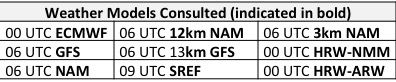
NWP Model Discussion

The weather models are in consensus on the main synoptic features of the medium range period, which gives us confidence in the broad features of the air quality forecast. The period begins on Wednesday with an open upper-level longwave trough centered over MI, moving slowly into southeastern ON by 00Z Thursday. At the same time, the upper level ridge currently over the Mid-Atlantic will move eastward to New England and offshore. A small shortwave along the NC coast will slowly drift offshore on Wednesday as the day progresses. The Great Lakes upper-level trough will move over the Mid-Atlantic on Thursday morning, while a large upper level ridge builds over the central Plains. This ridge will build eastward, with its axis over the Mississippi River Valley by 12Z Friday and over the Mid-Atlantic by 12Z Saturday. A broad but shallow upper-level trough developing across the northern U.S. Plains/southern Canadian Prairies over the weekend will push the upper-level ridge further eastward on Sunday, taking its center into the Atlantic and its axis over New England; the Mid-Atlantic will be on the western edge of the upper-level ridge for the second half of the weekend. The corresponding mid-level ridge, centered over the Gulf Coast on Thursday, will push north and east in the wake of the departing Mid-Atlantic trough. The center of the mid-level ridge will be over the Great Lakes/Ohio River Valley on Friday and the NMA on Saturday, before moving offshore on Sunday. The ridging will be strong enough to inhibit precipitation from Friday through Sunday.
The Dailies
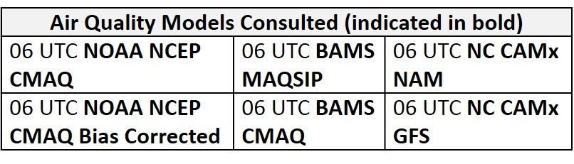
Day 1 (Wednesday): Wednesday will be seasonably cool with onshore flow both aloft and at the surface. The Great Lakes low will skirt the region to the northwest, bringing precipitation into the Mid-Atlantic from west to east. Rain will begin in the morning in the western Mid-Atlantic, moving to I-81 by 18Z. There is still discrepancy in the weather models regarding how far east precipitation will push in the afternoon. The 12km NAM brings showers to I-95 by 21Z, for example, while the 13km GFS keeps precipitation west of I-95 until around 06Z Thursday. Regardless of the exact timing and coverage of precipitation, the weather models increase clouds along the I-95 Corridor in the afternoon. Diminishing afternoon sunshine, in conjunction with onshore flow, will limit ozone production. The air quality models are responding to these conditions by keeping essentially the entire region under Good ozone on Wednesday. As a result, the risk for an ozone exceedance is Slight.
Day 2 (Thursday): The upper-level trough moving over the region on Thursday will pull a weak cold front to I-95 in the late morning. The main effect of this front will be to promote showers and thunderstorms overnight and into the morning hours; rain will be heavy at times. The front will slow as it reaches the Atlantic coast around lunchtime, allowing clouds and showers to linger along the I-95 Corridor through the early afternoon. Some clearing is possible in the late afternoon, with partly sunny skies likely. The BAMS and NC air quality models are leaning toward more afternoon clearing, with Moderate ozone along I-95. Given the widespread precipitation overnight, lingering clouds/showers in the early afternoon, and breezy westerly surface winds in the wake of the front, this seems overdone. Therefore, the risk of an ozone exceedance will remain Slight for Thursday.
Day 3 (Friday): A mid-summer heat wave will begin on Friday and continue through at least Sunday. Temperatures will ramp up into the low-to-mid 90s °F on Friday as the mid- and upper-level ridges build toward the Mid-Atlantic. Sunny skies, subsidence, and light northwesterly surface winds, with bay and sea breezes likely, will promote ozone formation. The one limiting factor will be northwesterly transport aloft. Given the position of the mid-level ridge, 36-hr back trajectories ending at KPHL on 12Z Friday originate from northern WI. Although this transport pattern will support plenty of warm air advection aloft, the actual air mass in the residual layer may be relatively clean, which could limit how fast ozone rises along the I-95 Corridor in the NMA. The NC-GFS models are responding to this transport pattern by keeping Good ozone in locations roughly east of I-99 and north of I-76 in the NMA, with isolated USG ozone in PIT. The BAMS models are more aggressive, with USG ozone in PIT and along I-95. The main forecast questions for Friday will be the impact of northwesterly flow aloft on ozone in the residual layer, as well as how quickly ozone can form locally. The chance for an ozone exceedance will jump to Appreciable, with a focus on locations south and east of I-95, along with western PA.
Day 4-5 (Saturday-Sunday): It will be an extremely hot weekend, with temperatures approaching 100 °F. With strong mid- and upper-level ridges moving overhead on Saturday and then offshore on Sunday, subsidence will keep skies fully sunny and surface winds light. 36-hr back trajectories ending at KPHL are slowly westerly (from Lake Erie) on Saturday and recirculating on Sunday. I can’t really see any factors that could limit ozone formation over the weekend except possibly lower Sunday emissions, which would only be a factor for locations not adjacent to I-95. Shore traffic and a/c use will both be high, maximizing NOx emissions. The risk of an ozone exceedance is High for both Saturday and Sunday.
-Huff