Author Archives: William F. Ryan

Mid-Atlantic Medium Range Air Quality Discussion, Issued Friday, August 4, 2017

Mid-Atlantic Medium Range Air Quality Discussion, Issued Friday, August 4, 2017
Medium Range Air Quality Outlook  Mid-Atlantic Region

Issued: Friday, August 4, 2017
Valid: August 5-9, 2017 (Saturday-Wednesday)

Summary:

After several weeks of hot weather and wild swings in local and regional air quality, we will enter a quiet, cleaner period that will persist into next week. A large upper level trough with a series of embedded disturbances will keep temperatures below average and air quality in the Good to Moderate range across the mid-Atlantic.

Weather Model Discussion:

The standard set of 0600 UTC numerical model forecasts were consulted for this discussion. While there are some differences in the finer grain aspects of the forecasts, the models are in good overall agreement with the result that forecast confidence is higher than average through the medium range. A broad trough over the northern US with embedded short wave disturbances will push frontal boundaries, with rain and cloudiness, through the mid-Atlantic on Saturday and again on Monday. Between frontal passages, a dry and cool air mass will limit any significant build up of pollutants.

Dailies:

A cold front will reach the I-95 Corridor Saturday morning with precipitation expected to accompany its passage. The air mass will gradually become cooler and much less humid behind the front. The cleaner air will be in place across most of the mid-Atlantic by Saturday afternoon. The combination of clouds, precipitation and an entering clean air mass will make for only a Slight risk of poor air quality in the mid-Atlantic on Saturday.

Sunday will be a very pleasant day across the region weather-wise. High pressure moves over Virginia. Temperatures and dew points will be below normal with plentiful sunshine.

Regional ozone concentrations will be quite low in the dry post-frontal air mass but sunny skies will allow ozone to accumulate later in the day. With a clean start, the risk of high ozone on Sunday will remain Slight. Particles concentrations will remain low due to the very dry air mass.

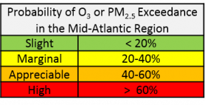
A warm front pushes north through the mid-Atlantic on Monday with rain likely. The associated cold front is expected to reach the I-95 Corridor Tuesday morning with high pressure building over PA on Wednesday. Rain will keep the mid-Atlantic in the Slight risk category on Monday. Expect a slow rise in pollutants on both Tuesday and Wednesday with a Marginal risk by Wednesday.

-Ryan

Mid-Atlantic Medium Range Air Quality Discussion, Issued Sunday, August 2, 2015

Medium Range Air Quality Outlook
Mid-Atlantic Region

Issued: Sunday, August 2, 2015
Valid: August 3-7, 2015 (Monday – Friday)

20150803-mediumrange

MedRange_Cats_2

Summary:

An upper level low moving slowly across southern Canada will spawn a series of weak frontal boundaries that will cross the mid-Atlantic during the week. Warm weather and mostly sunny skies will keep ozone in the Moderate range. Particle concentrations will move up and down as humidity and ventilation varies day to day but will be generally in the low Moderate range.

Discussion:

The forecast models (NAM, GFS and ECMWF) remain internally consistent and in good agreement with each other through the medium range resulting in high confidence in the weather and air quality forecasts. In the large scale flow, a closed upper level low just west of James Bay will drift to the east, reaching QC by Wednesday. Zonal flow will then set up for the remainder of the period with another deep trough forming to our west late Friday. At the surface, this pattern will be associated with a series of weak frontal boundaries moving through the mid-Atlantic. This will prevent any significant build-up of pollutants although sunny skies and humid air will keep air quality in the Moderate range for the bulk of the coming work week.

On Monday it will be warm, sunny and humid with strong southwest winds. Deep vertical mixing and steady winds will keep air quality in the Moderate range with highest concentrations along the I-95 Corridor.

The forecast models have slowed the approach of the first in a series of cold fronts and we now expect the front to reach the I-95 Corridor during the Tuesday morning rush hour. There will be significant convection west of the mid-Atlantic late Monday into the nighttime hours. For Tuesday, there is slight change of rain in the mid-Atlantic. Winds will shift west and remain strong while deep vertical mixing is again expected. Air quality will be at the Good/Moderate threshold with highest concentrations east of I-95.

A change in air mass will lag the frontal passage with drier air finally filtering in late Tuesday.   The next weak cold front is expected during the day Wednesday. Air quality remains in the Good to low Moderate range. Humidity returns Thursday with one more frontal passage Friday. Moderate air quality is expected both Thursday and Friday.

-Ryan

Mid-Atlantic Medium Range Air Quality Discussion, Issued Saturday, August 1, 2015

Medium Range Air Quality Outlook
Mid-Atlantic Region

Issued: Saturday, August 1, 2015
Valid: August 2-6, 2015 (Sunday – Thursday)

20150802-AQ-table

MedRange_Cats_2

Summary:

Moderate air quality will be the rule for most of the medium range period. An upper level low over James Bay on Monday will move slowly east and several weak frontal boundaries will cross the mid-Atlantic. The day of most interest will be Monday as temperatures return to the 90’s F although strong winds should ventilate the region enough to keep peak concentrations in the Moderate range.

Discussion:

The forecast models have been consistent over the past several runs leading to higher confidence in both the weather and air quality forecasts through the medium range.

An upper level closed low will be centered west of James Bay early Monday and remain in place through Tuesday before slowly moving eastward to southern QC on Wednesday. As the low opens and moves further east Thursday, zonal flow will set up. This pattern is consistent with generally Good to Moderate air quality in the mid-Atlantic.

Surface high pressure over WV, with a coastal front over eastern NC will result in light westerly winds, mostly sunny skies and Moderate levels of both ozone and particles in the mid-Atlantic. By Monday, winds will shift to the southwest and increase in strength. Temperatures will rise to the low 90’s F and dew points to the upper 60’s F. This pattern is conducive to both ozone and fine particle formation. However, steadily increasing winds will keep air quality in the Moderate range.

A weak cold front will reach the I-95 Corridor on Tuesday morning. Although weak, this boundary will bring a drier air mass and steady westerly winds, along with deep vertical mixing. As a result, particle concentrations are likely to drop to the Good range while ozone concentrations will decrease but remain in the Moderate range.

The frontal boundary dissipates over the southern mid-Atlantic on Wednesday with another frontal passage expected early Thursday morning. Clouds, particularly south of the Mason Dixon Line, and a chance of showers on Wednesday will bring Good to low Moderate air quality. A cooler and slightly drier air mass after the front passes Thursday will keep air quality in the Good to low Moderate range.

-Ryan

Mid-Atlantic Medium Range Air Quality Discussion, Issued Sunday, July 19, 2015

Medium Range Air Quality Outlook
Mid-Atlantic Region

Issued: Sunday, July 19, 2015
Valid: July 20 – 24, 2015 (Monday – Friday)

MedRangeTable_20150720

MedRange_Cats_2

Summary:

The forecast models point to lower chances of precipitation on both Monday and Tuesday. As a result, there is a high chance of Code Orange ozone on Monday, mainly east of the I-95 Corridor. Slightly cooler and less humid on Tuesday but cloud cover extent is uncertain so that we continue with an appreciable risk of Code Orange ozone. Cooler and much less humid from Wednesday to Friday with Moderate air quality.

Discussion:

The forecast models are in good agreement with respect to the key air quality relevant issues over the medium range. The forecast for the larger scale pattern remains similar to yesterday’s model runs with a closed upper level low moving slowly from ON to QC and a trough developing over the eastern US. The main change in the model forecasts relate to the short term (Monday and Tuesday) and point to a lower chance of significant precipitation. This, in turn, has prompted a slight increase in the chances for USG ozone on both Monday and Tuesday.

On Monday, a weak cold front will reach the I-95 Corridor, on roughly a TTN-HGR line during the morning rush hour, and then stall and dissipate more or less in place. Previous model forecasts developed convection along this boundary but today’s runs of both the parameterized and convection-allowing forecast models show convection developing only west of the I-95 Corridor. With weekday emissions returning Monday, there is a high chance of Code Orange ozone. Near surface winds will be more westerly Monday so that the location of peak concentrations will be east of the I-95 Corridor. Particle concentrations rose into the Moderate range overnight and, with little change to the air mass, upper Moderate concentrations are expected on Monday.

There will be a step down in temperature and humidity on Tuesday with increasing clouds as a stronger cold front approaches from the west. The key forecast issue will be the timing and extent of cloud cover and convection. The forecast models have decreased the chances of precipitation on Tuesday. Although we expect concentrations of ozone and PM to decrease on Tuesday, there is still an appreciable risk of widely scattered Code Orange ozone.

We return to more seasonable weather on Wednesday with lower temperatures and humidity. Steady northwest flow and sunny skies will keep ozone in the Moderate range through Friday. Particles will drop further due to lower humidity with Good to low Moderate concentrations expected.

-Ryan

Mid-Atlantic Medium Range Air Quality Discussion, Issued Saturday, July 18, 2015

Medium Range Air Quality Outlook
Mid-Atlantic Region

Issued: Saturday, July 18, 2015
Valid: July 19 – 23, 2015 (Sunday – Thursday)

MedRangeTable_20150719

MedRange_Cats_2

Summary:

There is a high probability of scattered Code Orange ozone on Sunday lingering into Monday although convection, possible both early and late in the day, may limit ozone Monday. Particles will be in the Moderate range. A closed low forming over eastern Canada will bring seasonable weather for the remainder of the medium range period with Moderate air quality expected.

Discussion:

The forecast models are in good agreement through the medium range period. A closed upper level low will form over Hudson’s Bay on Sunday and then slowly move eastward to northern QC by Thursday. A series of disturbances will rotate around the low with the strongest disturbance moving through the Great Lakes on Tuesday bringing an end to a short period of very warm weather in the mid-Atlantic. Sunday and Monday will be the days of most interest for air quality concerns as it will be quite warm, mostly sunny and very humid.

For Sunday, all the ingredients for high ozone levels are expected to be in place: temperatures in the mid-90’s F, light and variable winds, particularly in the morning and early afternoon hours, westerly transport and moderately strong cap on convection. However, in recent years we have seen very few Sunday USG occurrences due to reduced emissions both locally and regionally. As a result, we expect only scattered USG ozone on Sunday.

Monday will remain very warm and, with the addition of weekday emissions, prime for another USG ozone day. However, the forecast models continue to bring early morning convection through the mid-Atlantic that will serve to take the edge off the carry over of pollutants and their precursors. The WPC has a weak cold front just west of the I-95 Corridor early Monday and passes it through the region during the day. This could act as a trigger for afternoon thunderstorms. The risk of USG ozone continues Monday although slightly less enhanced than Sunday. PM will be in the mid-upper Moderate range both days.

A secondary cold front associated with the Great Lakes trough will pass through the region Tuesday. The remainder of the medium range will feature normal temperatures, slightly drier conditions and steady west to northwest flow. This will translate into Moderate air quality through Thursday.

-Ryan