

Medium Range Air Quality Outlook
Mid-Atlantic Region
Issued: Tuesday, July 17, 2018
Valid: July 18-22 (Wednesday-Sunday)
![]()

Summary
Building high pressure behind today’s cold front and the potential for smoke transport from Ontario will keep the potential for an exceedance Marginal through the rest of the work week before the arrival of an unseasonable, slow-moving mid/upper level low over the weekend ensures Good air quality. A considerably less humid air mass filtering into the region following Tuesday’s front will result in pleasant conditions across the Mid-Atlantic on Wednesday. This presumably clean air mass could be modified by remnant smoke from wildfires burning throughout ON, which is the lone forecast question for air quality across the Mid-Atlantic on Wednesday. This morning, upwind surface PM2.5 concentrations across the Great Lakes region are clean, suggesting that the risk of smoke transport is relatively low. Nevertheless, the possible smoke transport should be monitored for Wednesday and Thursday. Due to the possibility for smoke transport upwind and light surface winds under mostly sunny skies, the risk of an ozone exceedance will be Marginal on Wednesday. Although pleasant conditions will continue across the Mid-Atlantic, high pressure moving over the region, both aloft and at the surface, may begin to impact air quality on Thursday. Mostly sunny skies, light surface winds, and weak subsidence will promote ozone conducive conditions, but weak northerly flow aloft, assuming no smoke transport on Wednesday, should prevent excessive ozone formation from occurring. Given uncertainty in how quickly the post-frontal air mass will modify under high pressure throughout Wednesday and into Thursday, the risk of an ozone exceedance will remain Marginal with a focus on the I-95 Corridor from DC to NYC and western PA. High pressure, aloft and at the surface, will continue to impact the air quality forecast on Friday as it pushes eastward and offshore. Although a shift to onshore flow at the surface could concentrate pollutants further inland, the flow aloft should be robust enough by the afternoon to counter localized morning back trajectories, mostly sunny skies, and near/slightly above average temperatures across the eastern NMA/CMA. Given morning stagnation and recirculating back trajectories, and uncertainty as to how quickly the shift to southerly flow in the afternoon can clean out the air mass in place, the risk of an ozone exceedance will remain Marginal on Friday. Unsettled conditions will return to parts of the Mid-Atlantic on Saturday as an occluded low pressure system in the Great Lakes approaches the region from the west, and Tuesday’s front (stalled across the Southeast) lifts northward as a warm front into the SMA. A mix of unsettled conditions throughout the SMA/CMA and strong onshore flow across the NMA will result in a Slight risk of an ozone exceedance on Saturday. Sunday looks to be a washout throughout the entire Mid-Atlantic region as the occluded low pressure system seemingly stalls over the Ohio River Valley. Widespread and locally heavy precipitation impacting the region throughout the day will keep a Slight risk of an ozone exceedance on Sunday.
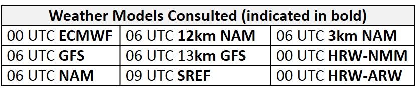
NWP Model Discussion
The weather models have come into closer agreement today for the entire medium range period. The mid-level trough currently passing over the northeastern U.S. will lag behind by 24 hours at upper levels, with the upper level trough axis moving over the eastern Mid-Atlantic around 12Z Wednesday. Although weak shortwave perturbations following the trough axis will keep weak upper level troughing over the Mid-Atlantic through 12Z Thursday, a low amplitude ridge will build in the wake of the trough, with its eastern edge moving into the Mid-Atlantic by 18Z Thursday. This ridge will be pushed eastward by the arrival of an upper level low developing over the Upper Midwest, with the ridge axis moving over New England by 00Z Saturday. The weather models have come into closer agreement today with the development of the unusual upper level low compared to yesterday’s model runs, although some differences still remain. Both the GFS and ECMWF bring this feature over the Great Lakes by 00Z Sunday but the models then disagree slightly with the evolution of this feature from here. The ECMWF has this feature as a cut off low throughout Saturday before opening back up on Sunday, slowly pushing eastward over the Ohio River Valley and Mid-Atlantic by 12Z Sunday where it lingers and weakens through Monday. The GFS keeps an open trough through 12Z Saturday when shortwave energy embedded in a secondary upper level trough dropping across MB and ON partially ejects into the Great Lakes low, reinforcing it as it develops into a closed low over IN/MI/OH by 00Z Monday. Regardless of these differences, the strength and location of the feature will promote clean air quality conditions across the Mid-Atlantic over the weekend and into the beginning of the work week.
The Dailies
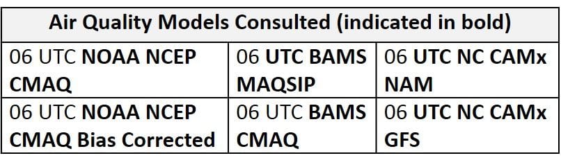
Day 1 (Wednesday): A considerably less humid air mass filtering into the region following Tuesday’s front will result in pleasant conditions across the Mid-Atlantic on Wednesday. Although surface high pressure building over the Great Lakes will shift back trajectories northwesterly across the entire region, this typically clean transport could be modified by remnant smoke from wildfires burning throughout ON. This possible transport of smoke appears to be the lone forecast question for air quality across the Mid-Atlantic on Wednesday. This morning, upwind surface PM2.5 concentrations across the Great Lakes region are clean, suggesting that the risk of smoke transport is relatively low. Nevertheless, the possible smoke transport should be monitored for Wednesday and Thursday. The Great Lakes surface high pressure will promote mostly sunny skies, light northerly surface winds, and near/slightly below average temperatures across the region on Wednesday. The air quality models react to the arrival of this post-frontal air mass by developing widespread Good range ozone across most of the region. The models are slow to clean out the SMA as they keep regional ozone in the upper Good/low Moderate range. Due to the possibility for smoke transport upwind and light surface winds under mostly sunny skies, the risk of an ozone exceedance will be Marginal on Wednesday.
Day 2 (Thursday): Although pleasant conditions will continue across the Mid-Atlantic, high pressure moving over the region, both aloft and at the surface, may begin to impact air quality on Thursday. The primary forecast question for Thursday will be the impact of light north/northwesterly surface winds across the eastern NMA throughout the afternoon hours and how this interacts with the development of sea/bay breezes along the east coast. Mostly sunny skies and near average temperatures will combine with light surface winds and weak subsidence to promote ozone conducive conditions, but weak northerly flow aloft, assuming no smoke transport, should prevent excessive ozone formation from occurring. The air quality models gradually increase regional ozone under high pressure by developing scattered Moderate ozone, mainly along the I-95 Corridor and coastal regions where sea/bay breezes will be a factor, and throughout western PA. A few of the NC air quality models develop isolated patches of USG along the I-95 Corridor, again likely in response to converging surface winds, but this seems unlikely at this time due to northerly transport aloft. Given uncertainty in how quickly the post-frontal air mass will modify under high pressure throughout Wednesday and into Thursday, as well as the chance for smoke transport from the ON/QC border, the risk of an ozone exceedance will remain Marginal with a focus on the I-95 Corridor from DC to NYC and western PA.
Day 3 (Friday): High pressure, aloft and at the surface, will potentially continue to impact the air quality forecast on Friday as it pushes eastward and offshore. Despite light/calm surface winds overnight, the center of surface high pressure will push offshore Friday morning, resulting in sustained south/southeasterly surface winds by the afternoon hours across the region. Although this onshore flow at the surface could concentrate pollutants further inland, it should be robust enough by the afternoon to counter localized morning back trajectories, mostly sunny skies, and near/slightly above average temperatures across the eastern NMA/CMA, especially north/west of I-95. The air quality models highlight the possibility for pollutants accumulating north and west of I-95 by developing areas of USG ozone along the I-81 Corridor through PA and MD, and throughout northern NY and southern NY. The air quality models develop widespread Moderate ozone across the rest of the NMA. Throughout the SMA rest of the CMA, the air quality models continue to gradually increase regional ozone with Good range ozone along coastal regions and Moderate ozone father inland. Given morning stagnation and recirculating back trajectories, and uncertainty as to how quickly the shift to southerly flow in the afternoon can clean out the air mass in place, the risk of an ozone exceedance will remain Marginal on Friday.
Day 4-5 (Saturday-Sunday): Unsettled conditions will return to parts of the Mid-Atlantic on Saturday as an occluded low pressure system in the Great Lakes approaches the region from the west, and Tuesday’s front lifts northward as a warm front into the SMA. The northward lifting of the warm front in the SMA will promote unsettled conditions throughout the SMA and CMA. It will also, in conjunction with the unusual mid/upper level low, result in strong onshore flow across the region. In regards to the system approaching from the west, guidance is not in agreement with the eastward push of precipitation. Despite the possibility for locations throughout the NMA remaining dry, sustained/breezy east/southeast surface winds and onshore flow aloft ahead of the lifting warm front will keep ozone formation minimal on Saturday. A mix of unsettled conditions throughout the SMA/CMA and strong onshore flow across the NMA are resulting in widespread Good ozone across the Mid-Atlantic in the air quality models. As a result, the risk of an ozone exceedance will lower to Slight on Saturday.
Sunday looks to be a washout throughout the entire Mid-Atlantic region as the occluded low pressure system seemingly stalls over the Ohio River Valley. Despite disagreement in the specifics between the GFS and ECMWF, widespread and locally heavy precipitation will impact the entire region throughout the day keeping ozone formation minimal. The risk of an exceedance will remain Slight.
-Enlow/Huff