

Medium Range Air Quality Outlook
Mid-Atlantic Region
Issued: Thursday, June 21, 2018
Valid: June 22-26 (Friday-Tuesday)
![]()

Summary
An upper level disturbance moving through the Midwest and into the NMA on Saturday will promote unsettled conditions across the region, keeping a slight risk of an exceedance through the first half of the weekend. A stronger, secondary cold front will push into the NMA on Sunday, promoting scattered showers and thunderstorms throughout the day. There are questions about the timing of the cold front. The primary forecast question for Sunday will be the timing of the cold front and coverage of associated precipitation/cloud cover. Due to a shift to westerly flow and uncertainty in the precipitation forecast, the risk of an exceedance will increase to Marginal with a focus on the I-95 Corridor from BAL to northern NJ. Surface high pressure moving southward across Ontario will push the cold front further southward on Monday. A noticeably drier and presumably clean air mass will filter into the NMA and CMA. There are wildfires burning in SK and MB that are producing some light to moderately dense smoke across southern Canada, however, which will need to be monitored early next week as the transport pattern turns northerly. In the SMA, the proximity of the frontal boundary may result in a few afternoon thunderstorms but their coverage and associated cloud cover will be the primary forecast question. For now, we think post-frontal conditions in the NMA and CMA and afternoon precipitation in the SMA will keep ozone relatively low, for a Slight risk of an ozone exceedance. Surface high pressure will pass over the Mid-Atlantic on Tuesday, resulting in pleasant conditions throughout the region. Mostly sunny skies and weakening surface winds will be favorable for ozone formation in locations west of I-95. Along and east of I-95, onshore surface winds should be able to limit any excessive ozone formation. The risk of an exceedance will return to Marginal with a focus on the western Mid-Atlantic.
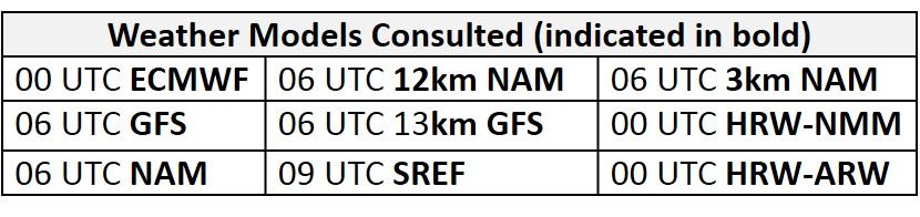
NWP Model Discussion
Aside from a few minor differences, the weather models remain in agreement with the synoptic pattern throughout the medium range period. An upper level closed low currently over IA/MO will continue to push eastward into the Ohio River Valley by 12Z Friday, opening up by 00Z Saturday. This disturbance will continue to weaken as it edges into the western Mid-Atlantic around 12Z Saturday, forming a broad longwave trough over the entire CONUS, with many embedded shortwaves. The arrival of this upper level disturbance across the Midwest will temporarily depress the mid-level westward extension of the Bermuda High southward into the Gulf of Mexico until 12Z Saturday. Throughout Saturday and Sunday, a persistent longwave trough over eastern Canada will interact with the remnants of the Midwest disturbance, causing it to stretch northeastward and eventually merge with the Canadian longwave trough beginning around 06Z Sunday. By 18Z Sunday, the Canadian trough will be reinforced by embedded shortwaves dropping southward across Hudson Bay. On Monday, this trough will sweep across the northeast US reaching the New England coastline by 00Z Tuesday. At the same time, a ridge will be building in the wake of the trough, centered over the Mississippi River Valley and Midwest. On Tuesday, this upper level ridge will extend eastward over the Mid-Atlantic as it merges with the westward extension of the Bermuda High at mid-levels by 00Z Wednesday.
The Dailies
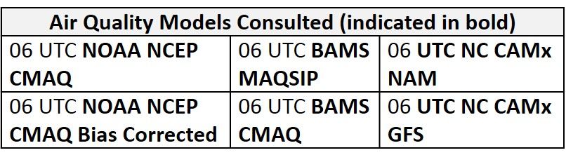
Day 1 (Friday): Friday will be an unsettled day across most of the Mid-Atlantic. A low pressure system moving eastward through the Ohio River Valley will slowly lift the lingering frontal boundary northward in the CMA. The northward advancing front and strong onshore flow will result in a broad shield of locally heavy rain and clouds across most of the NMA and northern CMA. These widespread unsettled conditions will limit temperatures to below average values. In the SMA, convection-allowing models suggest that periods of sun and clouds will combine with above average temperatures and relatively humid air mass to trigger scattered afternoon thunderstorms. Widespread precipitation across the Mid-Atlantic is apparent in most of the air quality models as they develop widespread Good range ozone. The lone region of widespread Moderate ozone is in the BAMS-MAQSIP across most of PA, but we think this is overdone, considering the weather models are keeping low and mid-level clouds across the entire NMA. The NC models also hint that ozone concentrations could near the Moderate range across PA as they show upper Good range ozone. At this time it seems most likely that precipitation and cloud cover will be widespread enough to discredit this feature in the models. Across the SMA, scattered precipitation, cloud cover and southwesterly transport (sourcing from the LA coast) are resulting in Good range ozone in the models. The risk of an exceedance will be Slight on Friday.
Day 2 (Saturday): Saturday will be another unsettled day for the NMA and CMA as the occluding low pressure system brushes the region to the northwest. The warm front will begin to lift northward into the NMA before its associated eastward advancing weak cold front catches up over PA in the afternoon. Widespread precipitation will blanket the northern half of the Mid-Atlantic with afternoon thunderstorms possible in the eastern CMA and NMA. The warm sector of the system will gradually shrink as the system occludes, keeping temperatures below average to the west of I-81 but temperatures will rise to near average to the east due to brief southwesterly transport in the warm sector. In the SMA, periods of sun and clouds and persistent southwesterly flow will promote near average temperatures. A plume of moisture along the coastal regions of NC will allow the opportunity for afternoon thunderstorms but the rest of the region will remain mostly dry. The air quality models are in agreement with most of the region under Good range ozone but the BAMS models both have a patch of Moderate ozone along I-95 and surrounding areas. This area of Moderate ozone is in the realm of possibility if there is enough afternoon sun, but it’s not clear how quickly morning clouds and precipitation will move away to the north. Nevertheless, breezy onshore surface winds and periods of heavy overnight and morning precipitation should be able to limit ozone formation. The risk of an ozone exceedance will remain Slight.
Day 3 (Sunday): A stronger, secondary backdoor cold front will push into the NMA sometime on Sunday (or early Monday), promoting scattered showers and thunderstorms throughout the day. The numerical models are not in complete consensus regarding the timing of this front; the NAM is the fastest, bringing the front into the NMA on Sunday afternoon, while the EC is the slowest, delaying the arrival of the front until early Monday. WPC seems to be taking a consensus forecast. Partly cloudy skies and a shift to westerly flow will allow for near or slightly above average temperatures across the NMA and CMA. In the SMA, continued warm air advection (from the west) and partly cloudy skies will allow temperature to rise into the upper 90s °F. The air quality models are responding with widespread upper Moderate ozone across the NMA and eastern CMA. This is likely due and light westerly flow and sufficient afternoon strong June sunshine. The primary forecast question for Sunday will be the timing of the cold front and coverage of associated precipitation/cloud cover. Due to uncertainty in the precipitation forecast, the risk of an exceedance will increase to Marginal with a focus on the I-95 Corridor from BAL to northern NJ.
Day 4-5 (Monday-Tuesday): Surface high pressure moving southward across Ontario will push the cold front further southward into the CMA on Monday. The air mass behind this front will be substantially drier (dew points in the 40s to 50s °F), somewhat cooler, and presumably clean. There are wildfires burning in SK and MB that are producing some light to moderately dense smoke across southern Canada, however, which will need to be monitored early next week. Mostly sunny skies and low atmospheric moisture will promote near average temperatures in the northern half of the Mid-Atlantic. In the SMA, another day of westerly/southwesterly transport will allow temperatures to remain above average under partly cloudy skies. A few afternoon showers and thunderstorms are possible across NC and southern VA as the weak frontal boundary slowly pushes south. The air quality models develop a swath of Moderate ozone across the CMA along and ahead of the frontal boundary. The BAMS models highlight eastern VA with the highest ozone concentrations while the NC-GFS2 highlights eastern NC. The air quality forecast for Monday will depend on precipitation and cloud coverage across the CMA and SMA, but for now, we think post-frontal conditions in the NMA and CMA and afternoon precipitation in the SMA will keep ozone relatively low. As a result, the risk of an ozone exceedance will return to Slight.
Surface high pressure will pass over the Mid-Atlantic on Tuesday, resulting in pleasant conditions throughout the region. Although high pressure will be weakening flow across the region, a cooler and presumably clean air mass filtering in will result in seasonable temperatures across the entire Mid-Atlantic. Mostly sunny skies and weakening surface winds will be favorable for ozone formation in locations west of I-95. Along and east of I-95, onshore surface winds should be able to limit any excessive ozone formation. The risk of an exceedance will rise to Marginal with a focus on the western Mid-Atlantic.
-Enlow/Huff