

Medium Range Air Quality Outlook
Mid-Atlantic Region
Issued: Monday, June 18, 2018
Valid: June 19-23 (Tuesday-Saturday)
![]()

Summary
A backdoor cold front arriving on Tuesday will bring some relief from the heat and humidity in place across the Mid-Atlantic. The arrival of this weak cold front will bring afternoon unsettled conditions to CMA and a cleaner air mass to the NMA. In the SMA, sunny skies, above average temperatures, northwesterly transport, and westerly surface winds keep the risk for an ozone exceedance Appreciable on Tuesday. Shortwaves propagating over the Ohio River Valley and the lingering frontal boundary across the CMA will keep unsettled weather in the NMA and CMA on Wednesday. Oppressive conditions will persist in the SMA as the heatwave continues but afternoon showers and thunderstorms appear more likely. Increasing cloud cover and afternoon precipitation in the SMA will bring the risk of an exceedance down but only to Marginal due to some uncertainty regarding the placement of the stalled front and coverage of associated cloud cover. There will be a mixed bag of conditions across the Mid-Atlantic on Thursday as Tuesday’s cold front slowly pushes toward the SMA and a secondary backdoor cold front moves into the NMA. High pressure will promote mostly dry conditions across the NMA while upper level shortwaves and the slow moving frontal boundary result in unsettled conditions across the southern half of the Mid-Atlantic. Given the usual uncertainty regarding weak frontal boundaries, a Marginal risk of an ozone exceedance will remain on Thursday. Unsettled conditions will continue to impact the Mid-Atlantic on Friday and into the weekend as an area of low pressure moves into the Midwest on Friday. A shift to onshore flow aloft, partly cloudy skies and near average temperatures will keep a Marginal risk for an ozone exceedance on Friday, dropping to Slight on Saturday.
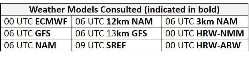
NWP Model Discussion
Aside from a few minor differences, the weather models are generally in agreement with the synoptic pattern throughout the medium range period. The upper level ridge over most of the eastern CONUS today will begin to flatten on Tuesday by the arrival of two upper level features. The first feature to impact the ridge will be on Tuesday, as shortwaves strengthen a semi-persistent longwave trough over eastern Canada. The edge of this trough will linger over the NMA through the end of the work week, weakening the influence from the upper level ridge, which will be pinched southward. The second feature will be an upper level cutoff low that has been in place over the Great Basin. This disturbance will weaken and then eject eastward over the Great Plains as an open wave by 12Z Wednesday, moving over NE/KS by 12Z Thursday. This feature will interact with the remnants of the disorganized tropical disturbance currently in the Gulf of Mexico, as they meet over the Mississippi River Valley around 18Z Thursday. The arrival this longwave trough from the west and the lingering eastern Canadian longwave trough will pinch the upper level ridge over the Mid-Atlantic on Thursday. This ridge will inhibit the eastward push of the central US longwave trough. This trough will begin to weaken as it moves into the Midwest around 00Z Saturday before opening up on Saturday and phasing with the Canadian longwave trough by 18Z Saturday. This area of broad upper level troughing over much of the northern US will push what remains of the Southeastern upper level ridge eastward and offshore by 00Z Sunday.
The Dailies
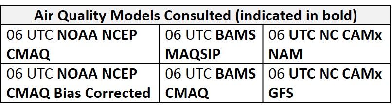
Day 1 (Tuesday): The arrival of a weak backdoor cold front will bring relief from humidity and ozone conducive conditions to the NMA and CMA on Tuesday. The cold front is forecast to push into the NMA from the north overnight, potentially reaching as far south as the MDL by 12Z Tuesday. Scattered showers and mostly cloudy skies are expected in the vicinity of the front overnight and into the morning and early afternoon. As the front pushes into the CMA, above average temperatures and a very moist air mass will promote widespread thunderstorms across the CMA in the afternoon. A noticeably less humid air mass will filter in behind the front as surface winds and flow aloft shift north/northwesterly. As a result, the risk for an ozone exceedance will diminish in the NMA and CMA. Careful evaluation should be given to the progression of the front with the 12Z model runs, however, as weak fronts tend to slow or stall during the summer months. In the SMA, mostly sunny skies and a very humid air mass will result in another day with oppressive conditions. Although the front will not reach the SMA, convective allowing models suggest that a few isolated thunderstorms could develop in the hot and humid air mass. The coverage of these storms may not be sufficient to keep ozone from rising to the USG level at isolated locations. The air quality models are responding to the arrival of the cold front and associated unsettled conditions as forecast ozone levels sink into the Good range across the NMA and northern half of the CMA. In the SMA, air quality models keep ozone levels elevated with widespread Moderate ozone in both BAMS and isolated USG in the NC models. Mostly sunny skies, above average temperatures, northwesterly transport and westerly surface winds in the SMA will result in an Appreciable risk for an ozone exceedance on Tuesday.
Day 2 (Wednesday): Shortwaves propagating over the Ohio River Valley and the lingering frontal boundary across the CMA will keep unsettled conditions in the NMA and CMA on Wednesday. Widespread showers and thunderstorms will develop in the western NMA and CMA in the morning hours before slowly pushing eastward throughout the day. Widespread cloud cover and periods of precipitation will knock temperatures back to near average values across the NMA and CMA. Oppressive conditions will persist in the SMA as the heatwave continues, but afternoon showers and thunderstorms appear likely. Partly cloudy skies and westerly transport aloft will keep temperatures well above average in the SMA. Increasing cloud cover and scattered precipitation results in scattered Moderate ozone across the SMA in the air quality models. As expected in the NMA and CMA, scattered cloud cover, precipitation, and northerly transport keep widespread Good ozone across the region, with scattered Moderate ozone along the southern part of the I-95 Corridor. The risk for an ozone exceedance will return to Marginal for the entire Mid-Atlantic, due to some uncertainty regarding the placement of the stalled front and coverage of associated cloud cover.
Day 3 (Thursday): There will be a mixed bag of conditions across the Mid-Atlantic on Thursday as Tuesday’s cold front slowly pushes toward the SMA and a secondary backdoor cold front moves into the NMA. With the exception of a few lingering morning showers, surface high pressure moving across the Great Lakes region will result in a pleasant day across the NMA and northern CMA. Partly cloudy skies and northerly transport aloft will keep temperatures around average values. Overhead shortwave perturbations and the slow moving frontal boundary will promote unsettled conditions across the southern half of the region. Widespread precipitation and cloud cover will limit temperatures near average values in the CMA but periods of sun and scattered precipitation will keep temperatures above average in the SMA. Unsettled conditions across the SMA and CMA and slightly cooler conditions in the NMA are evident in the air quality models as Good range ozone blankets most of the Mid-Atlantic, with pockets of scattered Moderate ozone across NC and along/east of I-95. Given the usual uncertainty regarding weak frontal boundaries, a Marginal risk of an ozone exceedance will remain on Thursday.
Day 4-5 (Friday-Saturday): Unsettled conditions will continue to impact the Mid-Atlantic on Friday and into the weekend as an area of low pressure moves into the Midwest on Friday. The development of this low pressure system will slowly lift Tuesday’s lingering frontal boundary northward as a warm front on Friday, promoting unsettled conditions along the western edge of the Mid-Atlantic. High pressure moving through southern ON/NY will promote partly cloudy skies and north/northeasterly flow aloft and southeasterly surface winds across the NMA and CMA. Widespread cloud cover and precipitation across SMA and western edge of the Mid-Atlantic is resulting in Good range ozone in the air quality models; however, the BAMS models and the NC-GFS versions are showing Moderate and isolated USG ozone along the MDL. This elevated ozone in the NMA and CMA could be in response to light surface winds, but northerly transport aloft and near average temperatures should be enough to prevent any excessive ozone formation. The risk of an exceedance will remain Marginal. Unsettled conditions will impact the entire Mid-Atlantic on Saturday as the warm front continues to lift northward through the CMA and NMA. Near average temperatures, breezy onshore flow and widespread unsettled conditions will drop the risk for an ozone exceedance to Slight.
-Enlow/Huff