Monthly Archives: August 2017

Mid-Atlantic Medium Range Air Quality Discussion, Issued Friday, August 4, 2017

Mid-Atlantic Medium Range Air Quality Discussion, Issued Friday, August 4, 2017
Medium Range Air Quality Outlook  Mid-Atlantic Region

Issued: Friday, August 4, 2017
Valid: August 5-9, 2017 (Saturday-Wednesday)

Summary:

After several weeks of hot weather and wild swings in local and regional air quality, we will enter a quiet, cleaner period that will persist into next week. A large upper level trough with a series of embedded disturbances will keep temperatures below average and air quality in the Good to Moderate range across the mid-Atlantic.

Weather Model Discussion:

The standard set of 0600 UTC numerical model forecasts were consulted for this discussion. While there are some differences in the finer grain aspects of the forecasts, the models are in good overall agreement with the result that forecast confidence is higher than average through the medium range. A broad trough over the northern US with embedded short wave disturbances will push frontal boundaries, with rain and cloudiness, through the mid-Atlantic on Saturday and again on Monday. Between frontal passages, a dry and cool air mass will limit any significant build up of pollutants.

Dailies:

A cold front will reach the I-95 Corridor Saturday morning with precipitation expected to accompany its passage. The air mass will gradually become cooler and much less humid behind the front. The cleaner air will be in place across most of the mid-Atlantic by Saturday afternoon. The combination of clouds, precipitation and an entering clean air mass will make for only a Slight risk of poor air quality in the mid-Atlantic on Saturday.

Sunday will be a very pleasant day across the region weather-wise. High pressure moves over Virginia. Temperatures and dew points will be below normal with plentiful sunshine.

Regional ozone concentrations will be quite low in the dry post-frontal air mass but sunny skies will allow ozone to accumulate later in the day. With a clean start, the risk of high ozone on Sunday will remain Slight. Particles concentrations will remain low due to the very dry air mass.

A warm front pushes north through the mid-Atlantic on Monday with rain likely. The associated cold front is expected to reach the I-95 Corridor Tuesday morning with high pressure building over PA on Wednesday. Rain will keep the mid-Atlantic in the Slight risk category on Monday. Expect a slow rise in pollutants on both Tuesday and Wednesday with a Marginal risk by Wednesday.

-Ryan

Mid-Atlantic Medium Range Air Quality Discussion, Issued Thursday, August 3, 2017

Medium Range Air Quality Outlook
Mid-Atlantic Region

Issued: Thursday, August 3, 2017
Valid: August 4-8, 2017 (Friday-Tuesday)

Summary:
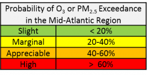
Uncertainty regarding coverage of afternoon thunderstorms and air mass characteristics keeps the risk for an ozone exceedance Appreciable on Friday, with a focus on locations between I-99 and I-95. The remainder of the period is marked by a fairly progressive pattern, with upper level troughing overhead, punctuated by a series of shortwaves moving through the trough, keeping the risk of an exceedance Slight. Friday will be warm and humid, with southerly flow aloft and at the surface, ahead of a cold front approaching from the west. Although there will be stronger southerly flow aloft on Friday compared to today, locations in the NMA and CMA west of I-95, where southerly transport will be less maritime influenced and more dominated by current modified air quality conditions in the inland SMA, are most at risk for an ozone exceedance on Friday. A line of pre-frontal thunderstorms moving through western PA/WV on Friday afternoon and more maritime southerly flow to the east should lower the exceedance risk for areas west of I-99 and east of I-95. The cold front will reach to the VA/NC border by 00Z Sunday. Morning precipitation and the arrival of a presumably clean air mass in the afternoon will limit ozone formation across the region on Saturday. Sunday will be sunny with diminishing winds as surface high pressure moves overhead. A cooler, less humid, and presumably clean air mass, with brisk northwesterly flow aloft and lower Sunday emissions, should promote Good to low Moderate ozone region-wide. The one thing to watch will be the possibility for transported dilute smoke from wildfires in the western US and Canada. Strong subsidence may allow some smoke to mix to the surface in the Mid-Atlantic. Monday and Tuesday will be unsettled as a new area of low pressure brings another round of showers to the region. Some clearing is possible on Tuesday afternoon, but with a presumably clean air mass in place, ozone formation will be limited.

Weather Model Discussion:

The operational models consulted for this analysis were the 06Z NAM, 06Z GFS, and 00Z ECMWF. The medium range period is fairly progressive, with upper level troughing over the Mid-Atlantic for the duration, punctuated by a series of concentrated shortwaves rotating through the trough. The period begins on Friday with the upper level trough located across most of the CONUS, centered around a closed low over Hudson Bay and a second, smaller shortwave circulation over WI at 12Z. The WI shortwave will slowly move northeastward during the day on Friday, reaching MI by 00Z Saturday. At mid-levels and the surface, this shortwave energy will quickly strengthen an area of low pressure over MI/ON that will pull a cold front to the OH/PA border by 00Z Saturday. The low aloft will weaken on Saturday and continue to slowly move northeastward into ON/QC, pulling its associated cold front into the Mid-Atlantic. The front will reach I-95 by 12Z and roughly to the VA/NC border by 00Z Sunday. As the upper level low continues to weaken and spin in place over QC on Sunday, the western edge of the Bermuda high will push back into the Mid-Atlantic at mid-levels, lifting Saturday’s cold front back northward as a warm front in the afternoon and evening.  The front will reach the vicinity of the Mason-Dixon Line (MDL) by 12Z Monday. Late Sunday into Monday, another area of shortwave energy dropping down around the top of the upper level trough into the northern Plains and moving into the Ohio River Valley (ORV) will develop a low along the front. The GFS and EC diverge with the timing of this feature by about 12 hours; the GFS is slower, keeping the low back in the ORV at 00Z Tuesday, while the EC brings the low to the PA/NY border. These differences propagate into Tuesday, when the EC’s stronger upper and mid-level low pulls a weak cold front into the Mid-Atlantic, reaching to NC by 00Z Wednesday. In contrast, the GFS’s weaker low stalls the front in the vicinity of the MDL. Although these model differences affect the precipitation forecast for Tuesday, they do not impact the air quality forecast at this point. WPC favors the EC solution, with the quicker-moving low on Monday-Tuesday.

The Dailies:

Friday will be very warm and humid, with southerly flow aloft and at the surface, ahead of the cold front approaching from the west. As has been the case for the past few days, scattered afternoon thunderstorms are likely in the warm and humid air mass. The hi-res models (06Z 3km and 12km NAM, 00Z NMM/ARW) are showing an organized line of pre-frontal thunderstorms moving through western PA/WV beginning at 18Z, reaching approximately to I-99 by 00Z Saturday. This line of storms will continue moving eastward overnight, but weaken. The hi-res models also have more scattered to isolated storms across the rest of the NMA and CMA at 18Z to 00Z Saturday. Southerly flow aloft will strengthen on Friday compared to today (Thursday), with 06Z GFS 36hr back trajectories ending at KPHL at 12Z Friday originating at the eastern NC/SC border. The air mass is not particularly clean in the SMA currently, however, particularly at inland locations. This suggests that locations in the NMA and CMA west of I-95, where southerly transport will be less maritime influenced and more dominated by current air quality conditions in the inland SMA, are most at risk for an ozone exceedance on Friday. The 06Z air quality models are responding to this trend, highlighting central PA/MD with the highest ozone for Friday. The BAMS models paint this area with USG ozone, while the NOAA and NC models limit ozone to the Moderate range. It certainly seems possible that locations between I-99 and I-95 that do not experience scattered afternoon thunderstorms may see isolated USG ozone, depending on how quickly upwind areas in the central/western SMA clean out today.   Breezy southerly afternoon winds along and east of I-95 should be sufficient, along with more maritime influenced southerly flow aloft, to limit ozone development. Therefore, the risk of an exceedance will be Appreciable for Friday, with a focus on locations between I-99 and I-95.

The cold front will move into the Mid-Atlantic overnight, reaching I-95 by 12Z and continuing on to approximately the VA/NC border by the evening. Clouds and rain showers associated with the frontal passage will linger along the I-95 Corridor in the morning, with clearing skies in the afternoon. Overnight precipitation, breezy afternoon winds, and the arrival of a presumably clean air mass will reduce the risk of an excedance to Slight.

Sunday will be sunny and seasonably cool, with much lower humidity. Surface high pressure will move overhead, diminishing surface winds, but brisk northwesterly transport aloft from southern ON (north of Lake Superior) should limit ozone formation across the region. The one thing to watch will be the possibility for transported dilute smoke from wildfires in the western US and Canada. There is a lot of thick smoke aloft over the north/central Plains, with more dilute smoke across much of central/eastern Canada. With high pressure briefly moving overhead on Sunday, strong subsidence may allow some smoke to mix to the surface. For now, the risk of an exceedance will remain Slight, given a presumably fresh air mass in place and below average temperatures.

Although the weather models diverge slightly on Monday, wet and cloudy conditions appear likely across the region. Saturday’s warm front will have moved back north as a warm front, and an area of low pressure will form along the front to our west late Sunday into Monday morning. This low, likely a wave, will ride eastward along the front on Monday. Between the wave and overrunning precipitation along the warm front, it will be a rainy day, with 1” of rain possible in PHL. The risk of an exceedance will remain Slight.

The weather models diverge again on Tuesday. The EC has a stronger low and faster associated cold front, which clears the region early, leading to clearing in the afternoon. The weaker GFS keeps the front across the central part of the region, giving us another day of clouds and rain. Either way, generally Good air quality seems likely, due to unsettled weather or the arrival of a clean post-frontal air mass. Slight risk for an exceedance will persist.

-Huff

Mid-Atlantic Medium Range Air Quality Discussion, Issued Wednesday August 2, 2017

Medium Range Air Quality Outlook
Mid-Atlantic Region

Issued: August 2, 2017
Valid: August 3-7, 2017 (Thursday-Monday)

Summary:

A weakening mid-level ridge will keep conditions generally favorable for potential ozone exceedances on Thursday and Friday; the main forecast questions will be the impact of a switch to southerly flow aloft and chances for scattered afternoon thunderstorms. Thursday will have similar weather conditions as Wednesday, with mostly sunny skies, very warm weather, and very light winds. The main difference will be the switch to faster southerly flow aloft, which historically can clean out locations along I-95. Given uncertainty in air mass characteristics and a lower chance for thunderstorms along I-95 compared to today, risk of an exceedance will be High on Thursday with a focus on the I-95 Corridor and the Washington D.C. metropolitan area. Friday will be similar to Thursday but with an increased chance for more widespread thunderstorms across the NMA as a cold front approaches from the west in the evening. Southerly flow aloft and at the surface will increase as well, which may help to limit ozone along I-95. Risk of an exceedance will lower to Appreciable with a focus on the I-95 Corridor in the CMA, where the effects of southerly flow aloft may be less. The cold front will push into the Mid-Atlantic early Saturday morning possibly resulting in some lingering unsettled conditions. There is some uncertainty pertaining to the precipitation forecast, but the arrival of a cooler, drier, and presumably clean air mass filtering in behind the front should limit ozone formation in most locations. Risk of an exceedance will drop to Marginal. High pressure will briefly return for Sunday. Despite mostly sunny skies across most of the region, the cooler air mass that followed Saturday’s cold front will remain over the NMA and CMA, limiting temperatures to slightly below average values. Strong northwesterly flow aloft may bring dilute smoke from Canada into the region, however. Risk of an exceedance will remain Marginal with a focus on the I-95 Corridor. Monday appears to be a washout across the Mid-Atlantic due to a wave of low pressure riding along Saturday’s front, which will move back northward as a warm front. Mostly cloudy skies and widespread showers and thunderstorms will drop the risk of and exceedance to Slight.

 
Weather Model Discussion:

The weather models consulted for this analysis were the 06Z GFS, 06Z NAM and the 00Z ECMWF. The weather models are generally in consensus until late in the medium range period when the GFS and EC slightly diverge with the timing of an upper level trough and associated surface wave. A weak upper level trough will remain over much of the eastern U.S. by 12Z Thursday. At the same time, a shortwave will drop down across the upper Midwest, reinforcing the longwave trough over the Great Plain by 18Z Thursday. Between 12Z and 18Z Friday, the shortwave energy over the Midwest will begin to phase with a parent upper level closed low over Hudson Bay/central Canada. As process happens, the leading edge of the trough axis will move over the Ohio River Valley by 00Z Saturday and into the Mid-Atlantic by 12Z Saturday, pulling a cold front into the region. By this time, the shortwave energy will be focused over the Great Lakes and southeastern ON, with the NAM and EC developing closed circulations over central ON. The upper level low will then begin to pull northeastward into QC by 12Z Sunday, allowing the troughing over the eastern U.S. to weaken; however, shortwaves moving across the Ohio River Valley and southern Great Plains will keep weak troughing over the eastern U.S. By 12Z Monday, another shortwave moving over the Midwest will reinforce the trough over the Great Lakes region. The GFS and EC begin to diverge at 12Z Monday with the eastward placement of this feature as the GFS is several hours slower than the EC. The EC gradually strengthens this feature, moving the trough axis into the western Mid-Atlantic by 00Z Tuesday, where the GFS keeps the axis in the Midwest by the same time. The shortwave feature will form a wave of low pressure that will move along Saturday’s cold front, which will move northward to the vicinity of the Mason-Dixon Line on Monday as a warm front. Despite the model differences regarding the speed of the wave, both the GFS and EC develop widespread precipitation on Monday.
The Dailies:

Thursday is a day to watch for potential ozone exceedances across the Mid-Atlantic. It will be a seasonably warm and humid day across the Mid-Atlantic. Weakening mid-level high pressure will promote mostly sunny skies in the morning hours. But increased humidity and temperatures in the upper 80s to low 90s °F will promote more clouds in the afternoon and evening hours with scattered thunderstorms across the NMA. Hi-res weather models are suggesting that thunderstorms will develop around 21Z Thursday in central PA, moving eastward by 00Z Friday. This signal also appears in the 03Z SREF, as precipitation is most likely to the north of I-76 between 21Z Thursday and 00Z Friday. The SMA is expected to remain dry on Thursday with temperatures in the low 90s °F. The major difference for Thursday compared to Wednesday is a stronger shift to southerly flow aloft as the mid-level high weakens and moves eastward. 36 hour 06Z back trajectories ending at KPHL at 12Z Thursday show relatively fast southerly flow at 500 m AGL, originating from eastern NC. Typically, this type of switch to southerly flow aloft will quickly reduce the potential for high ozone along the I-95 Corridor. We can see this morning that the air mass in place along I-95 has become quite modified compared to previous days, however, which indicates that ozone-conducive air is currently in place. The other main question will be the coverage of afternoon thunderstorms. Yesterday’s hi-res models didn’t show a particularly strong signal for afternoon convection today, but this morning’s HRRR is developing essentially widespread thunderstorms this afternoon around 18-19Z across BAL/PHL/ILG/TTN. It’s difficult accurately predict pop-up mesoscale induced thunderstorms 24-36 hours in advance. Another difference for Thursday is that SPC does not have the Mid-Atlantic in any kind of risk for severe weather, while today the far northeastern part of the region (PHL to southern New England) is in a Marginal risk. The air quality models were very unhelpful yesterday, at least for the PHL region, which had surprise isolated ozone exceedances. That said, today’s 06Z air quality models develop elevated ozone along the entire length of I-95 for Thursday. The NOAA model has isolated USG ozone in RIC, while the BAMS models have more widespread USG ozone in northern NJ, BAL/DC (along the Bay), and western NC. The NC air quality model is highlighting the Washington D.C. metro area, showing more Good ozone across the NMA than Moderate. As a result of these conditions, risk of an exceedance will be High on Thursday with a focus on the I-95 Corridor and the Washington D.C. metropolitan area.

Friday will be similar to Thursday but with an increased chance for more widespread thunderstorms across the NMA. A low pressure system moving through the Great Lakes will pull a cold front to the doorstep of the western Mid-Atlantic late Friday night. Flow across the region will be southerly both aloft and at the surface, pulling a more humid air mass northward ahead of the front. As a result, thunderstorms are likely ahead of the cold front across most of the NMA and western Mid-Atlantic between 18Z Friday and 00Z Saturday, as shown in the 03Z SREF. Locations in the CMA and SMA could still see an isolated thunderstorm or two but appears unlikely at this time. Mostly sunny skies in the morning hours will give way to increasing clouds as thunderstorms initiate but periods of sunshine will remain in between storms. Skies will remain mostly sunny in the CMA and SMA allowing temperatures to rise into the low 90s °F. Once again, the forecast questions center on the impact of stronger southerly flow aloft, originating near the eastern NC/SC border for the I-95 Corridor, and chances for afternoon thunderstorms. A second day of southerly flow aloft may be sufficient to limit ozone along I-95 to the Moderate range, despite otherwise ozone-friendly conditions. The 06Z BAMS models develop Moderate ozone with a few isolated areas of USG in the BAL/DC metro areas and in western NC. The NC air quality model appears to be buying into clouds and precipitation as it brings regional ozone into the Good range with scattered Moderate in the CMA and SMA. Risk of an exceedance will lower to Appreciable with a focus on the I-95 Corridor in the CMA, where the influence of southerly flow aloft may be less.

The cold front will push into the Mid-Atlantic early Saturday morning, reaching central PA/western VA by 12Z Saturday morning and pushing through to central VA by 00Z Sunday. Although the operational models are showing signs of scattered showers lingering across the region in the morning through the early afternoon, the 03Z SREF shows that precipitation is unlikely across most of the region with the exception of coastal NC. The combination of unsettled conditions and a presumably clean air mass filtering in behind the front will limit ozone formation in locations along and west of I-95. The front is only expected to push into the CMA during the daylight hours, keeping the SMA in the low 90s °F on Saturday. The 06Z air quality models are reacting to a cooler and presumably clean air mass behind the front as they drop regional ozone into the Good range, keeping parts of the eastern I-95 corridor and the eastern SMA in the Moderate range. Risk of an exceedance will drop to Marginal.

The far western edge of the Bermuda high will sneak into the Mid-Atlantic at mid-levels on Sunday. Despite mostly sunny skies across most of the region, the cooler air mass that followed Saturday’s cold front will remain over the NMA and CMA, limiting temperatures to slightly below average values. In the SMA, unsettled conditions will be caused by the nearby stalled frontal boundary. Scattered showers and mostly cloudy skies are expected across NC and will limit ozone formation. Despite light surface winds, and mostly sunny skies, strong northwesterly flow aloft will limit ozone formation. We will have to keep an eye on dilute smoke across central Canada on Sunday, as strong subsidence and brisk northwesterly back trajectories could bring some smoke into the Mid-Atlantic. The 06Z BAMS air quality models keep most of the region under Good ozone with isolated Moderate ozone developing along the I-95 corridor. Risk of an exceedance will remain Marginal with a focus on the I-95 Corridor.

Monday appears to be a washout across the Mid-Atlantic a wave of low pressure develops along Saturday’s cold front. Mostly cloudy skies and widespread showers and thunderstorms will prevent ozone formation. There is some disagreement between the models with the placement and coverage of precipitation but these differences should not impact air quality. Temperatures will plummet into the 70s °F across the NMA and CMA while the SMA will remain in the upper 80s °F. Widespread Good ozone is expected on Monday resulting in a Slight risk of an exceedance.

-Enlow/Huff

Mid-Atlantic Medium Range Air Quality Discussion, Issued Tuesday August 1, 2017

Medium Range Air Quality Outlook
Mid-Atlantic Region

Issued: August 1, 2017
Valid: August 2-6, 2017 (Wednesday-Sunday)

Summary:

Stagnating flow caused by a mid-level ridge will keep the risk of exceedances High on Wednesday, falling to Appreciable on Thursday, before a cold front arriving on Friday reduces the risk to Slight over the weekend. Wednesday is the day to watch for ozone exceedances. It will be the second day of strong subsidence and stagnation under the mid-level ridge, with bay/sea breezes likely. A weak shortwave moving over the NMA will bring the possibility for afternoon/evening thunderstorms, but they appear very isolated in nature. Localized back trajectories and a presumably modifying air mass suggest a High risk of exceedances along the I-95 and around the Chesapeake Bay. Thursday will be similar to Wednesday with a slightly increased chance for precipitation across the NMA and CMA and a shift to southerly flow aloft, which may be sufficient to take the edge off ozone along I-95. Risk of an exceedance will drop to Appreciable with the focus shifting to locations west of I-95 and inland areas of the SMA. Unsettled conditions will impact the Mid-Atlantic on Friday as the cold front of the next storm system approaches the western Mid-Atlantic. Scattered thunderstorms are possible ahead of the front in the afternoon hours while precipitation associated with the cold front will impact the western portions of the region throughout the afternoon and evening hours. Southerly flow will combine with periods of sunshine and clouds, temperatures and breezy surface winds to limit ozone accumulation and formation, lowering the risk of an exceedance to Marginal. Saturday will be seasonably cool and less humid across the Mid-Atlantic as a cold front pushes through the region to the SMA Atlantic coast and stalls. The arrival of a presumably clean air mass, along with unsettled conditions in the SMA, will drop the risk of an exceedance to Slight for the weekend.
Weather Model Discussion:

The weather models consulted for this analysis were the 06Z NAM, 06Z GFS and the 00Z ECMWF. The weather models have come into consensus with the synoptic setup through the end of the medium range period. A broad and weak upper level trough will be over most of the eastern U.S. by 12Z Wednesday as a strong upper level closed low moves over Hudson Bay. A series of shortwaves that develop across the Gulf Coast states will move through the base of the upper level trough over the Southeast U.S. By 12Z Thursday, concentrated shortwave energy riding in the northern stream flow will down across AB/SK and into the upper Midwest. This shortwave energy will strengthen quickly over MN/WI by 00Z Friday, reinforcing the existing broad through over the eastern U.S. and forming a mid-level low over NN/IA. Both the GFS and the EC develop a closed center of circulation over WI between 12Z and 18Z Friday before the shortwave energy begins to phase with the closed parent circulation over the Great Lakes/southern ON between 00Z and 12Z Saturday. As the upper level features phase, this will quickly pull the mid-level low and associated surface low pressure system through the Great Lakes region and into southeastern ON, while pulling a cold front into the Mid-Atlantic by 06Z Saturday. By 12Z Saturday, the closed low will be lifting northward, into ON/QC, and weakening. By 06Z Sunday, a broad and weak trough will remain over most of the eastern U.S. as shortwaves drop across the Midwest, forming another, weaker lobe of low pressure by 00Z Monday. This feature and other shortwaves across the eastern U.S. will keep troughing over the Mid-Atlantic throughout Sunday.
The Dailies:

Wednesday is a day to watch for potentially quickly rising ozone due to high pressure over the region resulting in stagnation with very localized back trajectories. On Wednesday, weak mid-level high pressure moving over the Mid-Atlantic will keep conditions mostly dry across the region. A weak shortwave moving over the NMA brings the possibility for afternoon/evening thunderstorms, however. Weak subsidence will bring mostly sunny skies for most of the region in the morning hours but will give way to increasing probability of precipitation and clouds into the afternoon hours. The 03Z SREF shows that precipitation becomes likely in locations to the west of I-95 between 18Z Wednesday and 00Z Thursday. Hi-res weather models are suggesting that showers and thunderstorms will be more scattered to isolated in nature with periods of sunshine in between. Temperatures across the Mid-Atlantic will reach the mid-80s/low90s °F under mostly sunny skies in the SMA and partly sunny skies in the NMA and CMA. Near average temperatures and mostly sunny sky conditions will combine with stagnating flow aloft and at the surface to create an ozone friendly environment. This appears in the 06Z air quality models, with all three models developing isolated USG ozone in a few areas. The NOAA and BAMS models show USG forming in eastern PA (e.g., PHL, Lehigh Valley, Susquehanna Valley, metro BAL), while the NC model highlights Washington D.C. Moderate ozone is shown along I-95, PIT, and central NC. Given that Wednesday will be the second consecutive day of very warm and stagnant conditions, with bay/sea breezes likely, the risk of an exceedance will rise to High with a focus on I-95 and areas around the Chesapeake Bay.

Thursday will be similar to Wednesday with a slightly increased chance for precipitation across the NMA and CMA. The main difference will be a shift to southerly flow aloft and at the surface in response to high pressure aloft started to shift eastward. Temperatures will remain in the upper80s/low 90s °F under mostly sunny skies in the morning and early afternoon hours. Skies in the NMA and CMA will become partly sunny by 18Z Thursday as the chance for showers increases. The 03Z SREF shows that showers and thunderstorms are most likely between 21Z Thursday and 00Z Friday in locations to the west of I-95 in the NMA and CMA. These showers and thunderstorms will be driven by instability as the Mid-Atlantic will be in the warm sector of a storm system moving across the Midwest. Surface winds will increase as thunderstorms will be in the area, but breezy and gusty winds will be localized, with essentially calm winds in the morning and light southerly in the afternoon for most locations. The rest of the region is expected to remain dry with mostly sunny skies as surface high pressure remains centered in western NC. A shift to southerly flow aloft will increase humidity but also result in a weak onshore flow for the NMA, but the nearby surface high pressure will result in localized flow aloft in the SMA. The BAMS air quality models keep the eastern NMA in the Moderate range with a swath of USG ozone along I-95 and central MD, while the NC model buys into thunderstorms and stronger onshore flow, dropping the eastern NMA into the Good range. The NC model also picks up on the subsidence in the SMA, keeping Moderate ozone across NC. The BAMS models also highlight the SMA but slightly higher than the NC model as they develop a few areas of USG ozone in NC (CLT). Risk of an exceedance will drop to Appreciable, due to higher chances for thunderstorms and a shift to southerly flow aloft, with the focus on locations west of I-95 in the NMA/CMA and inland areas of the SMA.

Unsettled conditions will impact the Mid-Atlantic on Friday as the cold front of the next storm system approaches the western Mid-Atlantic. Mostly sunny skies are expected throughout the region in the morning hours before giving way to partly sunny skies in the afternoon. Clouds will increase as afternoon convection begins to take place, resulting in scattered thunderstorms for the third consecutive day. Precipitation associated with the cold front will impact the western portions of the region throughout the afternoon and evening hours. Temperatures will be limited to the mid-to-upper 80s °F due to periods of clouds and precipitation across the region. Stronger southerly flow aloft will combine with periods of sunshine and clouds, temperatures and breezy southerly surface winds to limit ozone accumulation and formation. Although the BAMS air quality models respond the conditions in the SMA appropriately by developing widespread Good ozone, they keep upper Moderate/low USG ozone across the Susquehanna River Valley and BAL metro. This is either due to the BAMS model over-predicting or the models not buying into the possibly scattered thunderstorms. Despite USG ozone in the models in the NMA, risk of an exceedance will lower to Marginal due to stronger southerly flow aloft and breezy surface winds.

Saturday will be seasonably cool and much less humid across the Mid-Atlantic as the cold front pushes through the region to the SMA Atlantic coast. A few showers and thunderstorms are possible in the early morning hours as the front pushes into the region, but most of the showers during the daylight hours are expected to remain in the SMA, where the front will stall along the NC coast. A cool Canadian air mass filtering in behind the front will drop temperatures into the mid-to-upper 70s °F in the NMA and into the 80s °F in the CMA and SMA. A combination of a fresh air mass, breezy northwesterly surface winds, below average temperatures and a shift to northerly flow aloft will bring regional ozone into the Good range. This appears in the 06Z BAMS air quality models as they bring ozone across the NMA and CMA into the Good range with a band of Moderate ozone along the frontal boundary in the eastern SMA. Risk of an exceedance will be Slight on Saturday.

Sunday will be another pleasant day in the NMA and CMA while the stalled frontal boundary will result in unsettled conditions in the SMA. Mostly sunny skies in the NMA and CMA will allow temperatures to rebound back into the 80s °F. Continued northerly flow aloft will prevent ozone accumulation from becoming excessive, despite slackening surface winds as high pressure moves directly overhead and offshore. In the SMA, showers and thunderstorms are expected across the southern half of NC throughout the day. A combination of mostly cloudy skies, precipitation and the cool Canadian air mass finally pushing into the region, temperatures will fall into the low-to-mid 80s °F. A combination of a recent change in air mass in the NMA and unsettled conditions in the SMA will keep the risk of an exceedance Slight on Sunday.

-Enlow/Huff